Petersfield, Hampshire, GU31 5AT - 8 Acres Quality Pastureland with ancillary woodland beside the River Rother

- PROPERTY TYPE
Land
- SIZE
353,533 sq ft
32,844 sq m
Key features
- IDEAL FOR GRAZING, EQUESTRIAN, RECREATIONAL, CONSERVATION, BIO-DIVERSITY AND AMENITY USE
- AVAILABLE AS A WHOLE OR IN TWO LOTS
- LOT 2 - 8.116 ACRES - PRICE GUIDE: £225,000 TO £240,000
- FREEHOLD FOR SALE BY PRIVATE TREATY
Description
LOCATION: See attached Location Plan. The property is located south of the A272 just east of Petersfield and Sheet Village in the heart of the South Downs National Park. The main vehicular entrance to the property - shared with two other residential properties is What3Words/// is unleashed.enlighten.spit, and is shown coloured brown on the sale plan.
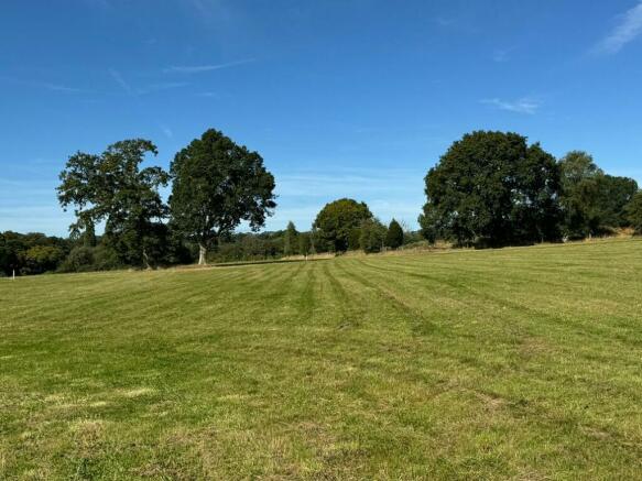
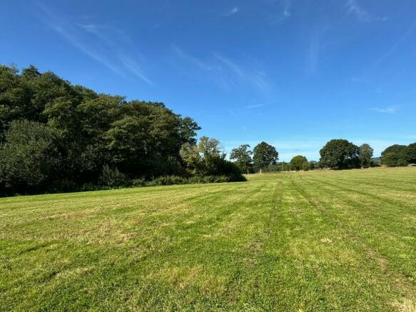
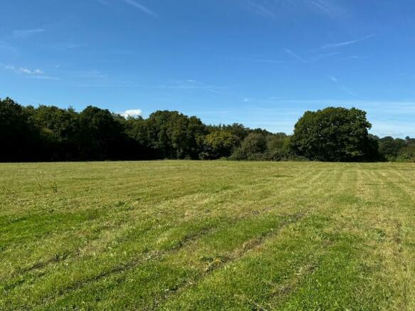
GENERAL DESCRIPTION: Close to Sheet on the outskirts of Petersfield Town and set well back off the A272 towards Rogate this block of pasture land is slightly sloping down towards the River Rother to the south and is very well sheltered and has high amenity value and adjoins other agricultural, arable and grassland. Conveniently located just off the A272 over a well-established private driveway with its own avenue of pine trees, this land was known as "Westmark Camp" during the Second World War which is evident in some of the original foundations of the buildings on the eastern boundary of Lot 2. The land is suitable for agricultural, horticulture, conservation, bio-diversity, equestrian, woodland creation and many other uses subject to planning where necessary.
DIRECTIONS: From Petersfield town follow the B2070 east out towards Sheet and then follow the signs to the A272 towards Rogate. After about 400m turn right into the private driveway shared with the adjoining two residential properties known as "Dove House" and "Lhiannon Thie".
VIEWING: Viewing is possible without an appointment at any time during daylight hours so long as prospective purchasers are in possession of a set of these sale particulars. Proceed down the pine tree lined avenue and through a galvanised "Private" signed unlocked access gate and drive on for another 100 yards and park next to the double gates in the eastern corner of Lot 2. You can park there and then walk all of the land on foot.
PLANNING: The land lies within East Hampshire District Council but is subject to Planning Policies of the South Downs National Park Local Plan. This land lies outside the Settlement Boundary of Petersfield and Sheet and is considered to be in the "Countryside".
BIO DIVERSITY NET GAIN (BNG): There may be the potential for parts of the property to be managed in such a way, and with new habitats being established, to be suitable for use as part of the new requirement for all development to provide a 10% Bio Diversity Net Gain. Such BNG credits can then be sold to Developers. More information available from the Vendor's Agents.
TITLE: The land is registered under HM Land Registry Title No: SH33861.
DESCRIPTION:
LOT 1 - 3.88 acres
This regularly shaped pasture paddock lies to the south of "Dove House" and its western boundary is formed by adjoining grass land, the southern boundary by the River Rother woodland and the eastern boundary by Lot 2. The land lies relatively level with a gradual slope to the south and is currently fenced only on its northern and western boundaries. The eastern boundary is formed by a number of substantial ancient oak trees which used to be growing in an old hedgerow which historically formed the boundary between the two Lots.
LOT 2 - 8.116 acres
Is accessed directly off the shared right of way and includes not only grassland but also frontage onto the actual River Rother and its surrounding woodland and also includes the remains of the original World War II Westmark Camp accommodation and buildings and infrastructure. Again, this land lies relatively level with a south southerly slope towards the River and has woodland on its southern boundary and a residential property known as "Lhiannon Thie" to the north. To the east there is an intensive horticultural crop currently of asparagus being grown on a 10-year cycle.
The woodland in Lot 2 is an attractive feature and backdrop to the property and is of mainly broadleaf overstorey with wet, marshy and boggy land down beside the River Rother itself which frequently floods into its natural flood plain when in spate - a really attractive River and waterside amenity and natural habitat.
All of the land - both Lots 1 and 2 - is shown on the Ministry of Agriculture Land Classification Plan as Grade 4 and the Soil Survey of South East England as Soilscape 6 described as freely draining slightly loamy soils. This land has the benefit of being able to abstract water from the River Rother for irrigation purposes if required.
POTENTIAL USES: This land is suitable for agricultural and horticultural farming, conservation, bio-diversity, equestrian, woodland creation and many other uses some of which may be subject to planning. Portable/mobile field shelters could be installed on the land which do not require planning permission but do provide shelter and shade for any livestock. In the recent past the land has been used for the cultivation and growing of nursery trees and shrubs, maize and grass for hay, silage and haylage as fodder for livestock.
ACCESS/RIGHTS OF WAY: Both Lots 1 and 2 will benefit from a full right of way for all purposes at all times over the main access track and driveway from the A272 shown coloured brown on the sale plan. If Lots 1 and 2 are sold separately to different buyers, then access to Lot 1 will be provided along the northern and western boundary of Lot 2 over a width of no more than 5m to allow an easy and unrestricted access. Lot 2 is subject to a right of way along its eastern and southern boundary into the woodland beside the River Rother.
METHOD SALE: The land is offered for sale by Private Treaty with Vacant Possession as a whole or in two Lots. The Vendors may invite Best Offers at any time. Prospective Purchasers should register their interest with the Selling Agents to whom offers will need to be submitted.
CONTACT: Timothy Gardner at Ian Judd and Partners LLP,
Brochures
Sale ParticularsPetersfield, Hampshire, GU31 5AT - 8 Acres Quality Pastureland with ancillary woodland beside the River Rother

NEAREST STATIONS
Distances are straight line measurements from the centre of the postcode- Petersfield Station1.4 miles
- Liss Station2.4 miles
- Liphook Station6.3 miles
About the agent
Ian Judd & Partners, Bishops Waltham
4 High Street, Bishops Waltham, Southampton, SO32 1AB
Chartered Surveyors • Land Agents • Rural Property Consultants
Specialising in the sale, purchase,valuation and management of
all types of rural property
Industry affiliations


Notes
Disclaimer - Property reference TJGADHURSTSHEETLOT2. The information displayed about this property comprises a property advertisement. Rightmove.co.uk makes no warranty as to the accuracy or completeness of the advertisement or any linked or associated information, and Rightmove has no control over the content. This property advertisement does not constitute property particulars. The information is provided and maintained by Ian Judd & Partners, Bishops Waltham. Please contact the selling agent or developer directly to obtain any information which may be available under the terms of The Energy Performance of Buildings (Certificates and Inspections) (England and Wales) Regulations 2007 or the Home Report if in relation to a residential property in Scotland.
Map data ©OpenStreetMap contributors.