Bramshall, Uttoxeter

- PROPERTY TYPE
Land
- SIZE
1,864,368 sq ft
173,206 sq m
Key features
- 42.80 Acres or Thereabouts
- For Sale as a Whole or in Two Lots
- Lot 1 - 34.74 or thereabouts Grassland
- Lot 2 - 8.05 acres or thereabouts Arable Land
Description
AVAILABLE AS A WHOLE OR IN TWO LOTS
LOT 1 - 34.74 ACRES OR THEREABOUTS - GRASSLAND
LOT 2 - 8.05 ACRES OR THEREABOUTS - ARABLE LAND
PLEASE SEE ATTACHED BROCHURE FOR FURTHER DETAILS.
Directions - From Uttoxeter, take the Bramhall Road (B5027) and continue for approximately 2.5 miles, the land will be situated on the left-hand side sign posted by one of our Agent’s ‘For Sale’ signs.
From Stone, take the B5027 towards Uttoxeter. After 8 miles, the land is on the right-hand side, as indicated by our Agent’s 'For Sale' signs.
From Stafford, take the A518 towards Uttoxeter. In Loxley turn left onto Bennetts Lane, signposted 'to Bramshall'. In Bramshall, turn left, towards Stone on the B5027. The land is situated on the left after approximately 1 mile as indicated by our Agent’s 'For Sale' signs.
Situation - The land is situated between Bramshall and Field, with good access off the B5027.
What 3 Words - ///hides.value.unscathed
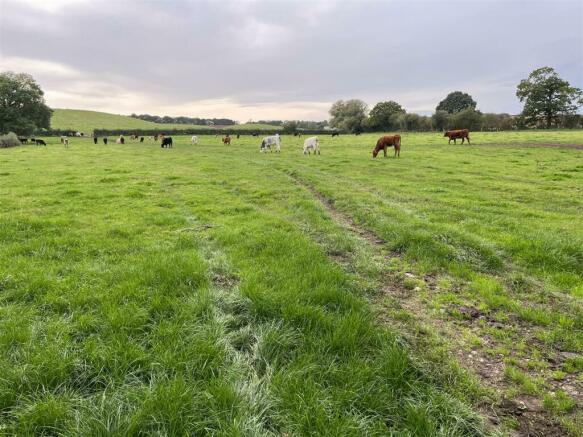
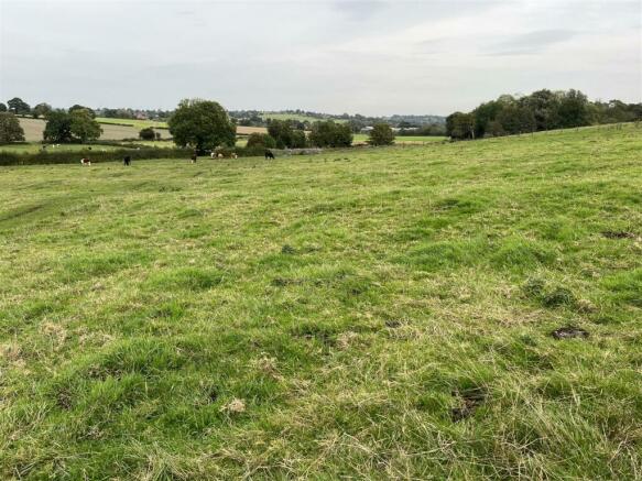
Description - LOT 1
The land extends to 34.74 acres altogether and is undulating in nature. The land is considered to be in good heart, suitable for mowing or grazing purposes.
The land is accessible from Bramshall Road via a track, the purchaser of the land will have access by right of way.
The land would be of interest to farmers, investors and specators.
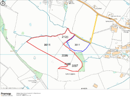
The land is shown in red on the attached plan, and can be further described in the schedule below: -
OS Field No Description Area (Ha)
2120 Grassland 1.70
3287 Grassland 2.54
2099 Grassland 3.24
9911 Grassland 6.50
2388 Grassland 0.08
14.06 Hectares
Or 34.74 Acres
Or Thereabouts
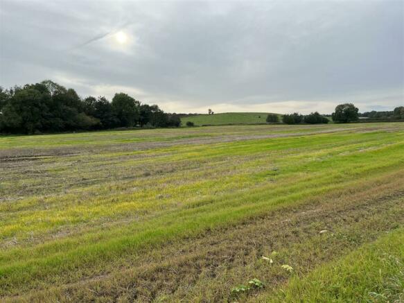
LOT 2
The land is level in nature and extends to 7.90 acres or thereabouts. The land is considered to be in very good heart capable of growing arable crops or converting to grassland if desired.
The land is accessible via a track from Bramshall Road, the purchaser of the land will have access by right of way.
The land will be of interest to farmers, investors and spectators.
The land is shown in blue on the attached plan, and can be further described in the schedule below: -
OS Field No Description Area (Ha)
3611 Arable 3.19
3.19 Hectares
Or 7.90 Acres
Or Thereabouts
Services - We understand that there are no mains services connected to the land.
Access - The land is accessible via gated access from Bramshall Road, with both lots having access by right of way. This can be seen edged in yellow on the attached plan.
Local Authority - The local authority are Staffordshire County Council and East Staffordshire Borough Council
Tenure & Possession - We understand vacant possession will be obtained on completion of sale.
Sporting Rights - We understand the vendor is to retain the sporting rights on the land.
Mapping - The plans provided in these particulars are indicative and for identification purposes only and interested parties should inspect the plans provided with the conditions of sale with regards to precise boundaries of the land.
Wayleaves & Easements - The property is sold subject to and with the benefits of all rights, including rights of way, whether public or private, light, support, drainage, water and electricity supplies and other rights and obligations, easements, quasieasements and restrictive covenants and all existing and proposed wayleaves for masts, pylons, stays, cables, drains and water, whether or not referred to in these stipulations, the particulars or special conditions of sale.
Please Note - The agent has not tested any apparatus, equipment, fixtures, fittings, or services and cannot verify they are in working order or fit for their purpose, neither has the agent checked the legal documents to verify the freehold/leasehold status of the property. The interested party is advised to obtain verification from their Solicitor or Surveyor.
Viewing - Viewings by Appointment only
Enquiries - For further information please contact our office on or email or alternatively contact Stephen Egerton (Ask4Change) via email or telephone .
Brochures
Particulars - Land at Stone Road, Bramshall.pdfBramshall, Uttoxeter

NEAREST STATIONS
Distances are straight line measurements from the centre of the postcode- Uttoxeter Station2.2 miles
About the agent
Graham Watkins, Leek
57 Derby Street, Leek, ST13 6JL
Graham Watkins & Co are a firm of chartered surveyors, estate and land agents, auctioneers and valuers incorporating Bury & Hilton Agricultural.
This firm was established following a split in the partnership of Bury & Hilton. The principal is Graham Watkins MRICS FAAV, who qualified in 1980, being a member of The Royal Institute of Chartered Surveyors and also a member of the Central Association of Agricultural Valuers.
Graham originates from an established farming background in m
Industry affiliations


Notes
Disclaimer - Property reference 32653813. The information displayed about this property comprises a property advertisement. Rightmove.co.uk makes no warranty as to the accuracy or completeness of the advertisement or any linked or associated information, and Rightmove has no control over the content. This property advertisement does not constitute property particulars. The information is provided and maintained by Graham Watkins, Leek. Please contact the selling agent or developer directly to obtain any information which may be available under the terms of The Energy Performance of Buildings (Certificates and Inspections) (England and Wales) Regulations 2007 or the Home Report if in relation to a residential property in Scotland.
Map data ©OpenStreetMap contributors.