Land Lanark Road, Garrion Bridge, Larkhall, ML9

- SIZE AVAILABLE
124,582 sq ft
11,574 sq m
- SECTOR
Land for sale
Key features
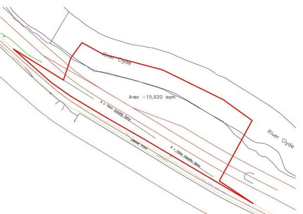
- SITE EXTENDS TO 1 .16 HA (2.86 ACRES)
- 160 M ROAD FRONTAGE
- FRONTS ONTO THE RIVER CLYDE
- SITUATED TOWARDS THE WESTERN END OF THE CLYDE VALLEY TOURIST ROUTE
- SUITABLE FOR A VARIETY OF USES
Description
The site is situated on Lanark Road (A72) forming part of the Clyde Valley Tourist Route between Larkhall and Lanark, in South Lanarkshire. It lies approximately 1 mile to the east of Junction 7 of the M74, the principal trunk road between Scotland and England and similarly from Garrion Bridge which provides connections to towns including Lanark, Wishaw, and Carluke.
DESCRIPTION
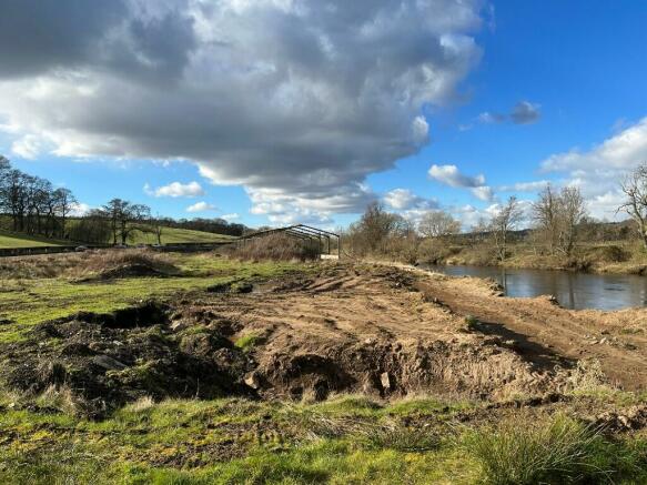
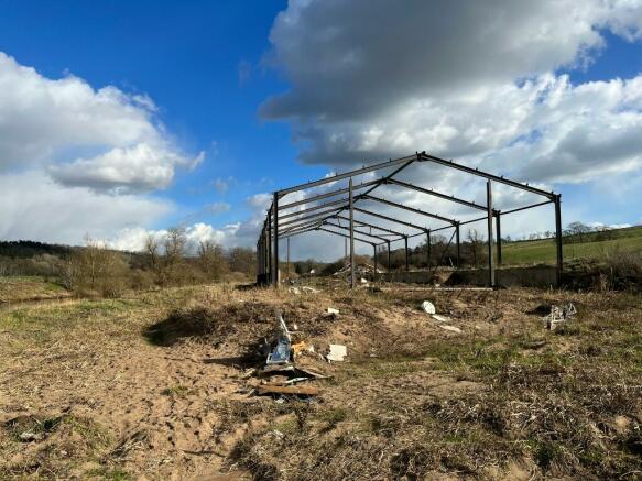
The site is irregular in shape sloping easterly towards the River Clyde. Due to agricultural works, the site levels have been raised in recent years and an entrance has been formed. The shell of a 440 sq m agricultural building has been constructed on site, although a recent planning consent has been granted to allow it to be extended to 1,000 sq m (P/22/0294).
The site extends to 1.16ha (2.86 acres) with a road frontage of 160 m. The title also extends to the mid-point of the river creating further development potential. Additional land can be offered should this be necessary.
The front page illustration shows how a Visitor Centre could sit on the site. This has been provided for guidance purposes only and would be subject to obtaining formal planning consent.
OPPORTUNITIES
This is expected to be the last commercial site available on the Clyde Valley Tourist Route between Larkhall and Lanark. It is exceptionally well positioned at the northern end of the route to attract business lying just off the M74 with traffic flow peaking at 4,500 cars on a Sunday. Possible uses of the site include:
Distillery
Garden and Gift Centre
Wedding Venue
Petting Farm
Holiday Park
Commercial Yard with Private Residence
Industrial Facility
Alternative Agricultural Use
PLANNING
Our client continues to have ongoing dialogue with South Lanarkshire Council Planning in relation to this site. They are willing to work with the successful bidder to secure whatever consent is necessary subject to agreeing satisfactory terms. The planning history can be viewed online at
A technical pack can be provided on request.
PRICE
Our client is seeking offers. Any offer must, however, include detailed information on the proposed development, funding arrangements and a business plan, if appropriate.
OFFERS
In the normal Scottish form addressed to this office.
LEGAL COSTS
Each party to bear their own legal costs.
DATE OF ENTRY
To be mutually agreed.
Brochures
Land Lanark Road, Garrion Bridge, Larkhall, ML9

NEAREST STATIONS
Distances are straight line measurements from the centre of the postcode- Merryton1.3 miles
- Larkhall Station1.4 miles
- Shieldmuir Station2.0 miles
About ALLIED SURVEYORS SCOTLAND, Glasgow
HERBERT HOUSE 24 Herbert Street, Glasgow, G20 6NB
Notes
Disclaimer - Property reference CA8565. The information displayed about this property comprises a property advertisement. Rightmove.co.uk makes no warranty as to the accuracy or completeness of the advertisement or any linked or associated information, and Rightmove has no control over the content. This property advertisement does not constitute property particulars. The information is provided and maintained by ALLIED SURVEYORS SCOTLAND, Glasgow. Please contact the selling agent or developer directly to obtain any information which may be available under the terms of The Energy Performance of Buildings (Certificates and Inspections) (England and Wales) Regulations 2007 or the Home Report if in relation to a residential property in Scotland.
Map data ©OpenStreetMap contributors.