Lot 1, Long Lane, Newport
£0.30 per sq ft
Business rates & charges may apply
- SIZE AVAILABLE
1,663,556 sq ft
154,550 sq m
- SECTOR
Land for sale

Key features
- Prime Location
- Flexible Use
- Income from Telecom Mast Lease
- Agricultural Barn
- Planning Potential (STPP)
- Cold War Nuclear Bunker
Description
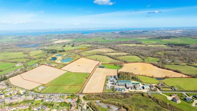
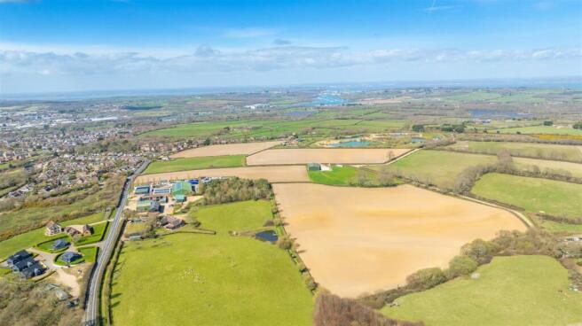
Situated on the outskirts of Newport, Isle of Wight, the property comprises 38.19 acres (15.45 hectares) of predominantly arable land with direct vehicular access via Staplers Road, ensuring good connectivity to Newport and surrounding areas. Newport town centre is approximately 2 miles away providing a comprehensive range of shops, eateries and local schools. The towns of East Cowes and Wootton offer additional amenities and access to ferry ports for mainland connections.
Lot 1
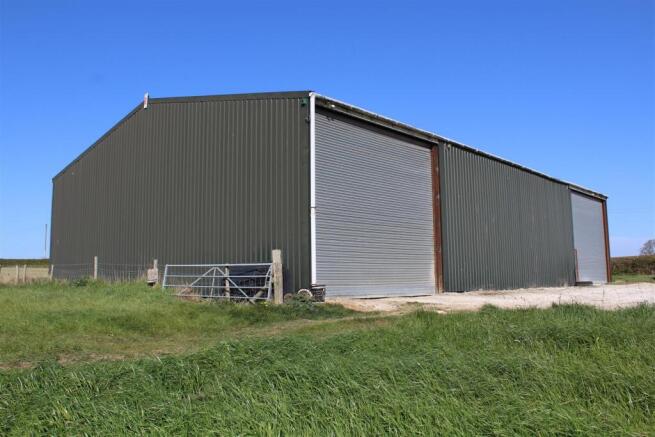
19.83 acres (8.02 hectares) comprising 17.08 acres of arable land and 2.75 acres of permanent pasture. The plot benefits from direct road access off Long Lane. This lot includes a modern agricultural building measuring 24m x 15m with a steel portal frame and corrugated steel sheet roof. The building also benefits from 2 roller shutter doors, a personnel door and single-phase electric supply. The building is currently being used for agricultural storage. There are two mobile homes being used for storage which are included in the sale, these are not connected to services.
General Remarks - METHOD OF SALE
The property is offered for sale by private treaty, as a whole or as two separate lots.
RIGHTS OF WAY
There are no public rights of way over the land. A neighbouring property has a right of access along the track hatched blue on the sale plan. If Lot 2 is sold separately from Lot 1 then Lot 2 will have a right of access over the track hatched blue (which forms a part of Lot 1).
SERVICES
There is a single-phase mains electric supply to the building in Lot 1.
TENURE AND POSSESSION
Freehold subject to a lease for the telecom mast, see below for lease details.
HOLDOVER
A holdover period of 3 months after completion will be applied to the barn for storage purposes. A holdover extending to the 30th September 2025 will be applied for any unharvested crop.
OVERAGE
(i)An overage provision is to be applied by the current vendors at a rate of 35% of the uplift in value above purchase value over a 30-year term triggered by a change of use planning permission, full planning approval, or permitted development. This development overage will not apply to development for agricultural use on the entire property and any development within the yellow hatched area. The overage does apply to residential, commercial and leisure use as well as natural capital credit sales on the remainder of the sale of the property.
(ii)A Gravel Royalty Overage provision is to be applied by the current vendors at a rate of 50% over a 50-year term triggered by gravel/mineral extraction following full planning permission or permitted development. For example, for every 1 tonne of gravel/minerals extracted, the vendor would be due 50% of the market value confirmed by the Royal Institute of Chartered Surveyors (RICS).
SPORTS, MINERAL AND TIMBER RIGHTS
The sporting mineral and timber rights are in hand and are included in the sale in so far as they are owned.
BOUNDARY FENCE
The vendor will erect a suitable stock proof fence between the points A-B and C-D, if required by the purchaser, within four months of completion of the sale.
BROADBAND AND PHONE COVERAGE
Download speeds of up to 40Mbps
Upload speeds of up to 7Mbps
4G Network Available
EPC
This property includes an agricultural barn that is exempt from EPC requirements due to low energy demand
LEASES
There is a lease for a private telecom mast located in Lot 2. The lease currently pays an annual rent of £4,000 and runs until 15th September 2041. For further details of the lease please contact the selling agent.
WAYLEAVES AND EASEMENTS
The property is sold subject to and with the benefit of all rights, including rights of way, whether public or private, light, support, drainage, water and electricity supplies an any other rights and obligations, easements and proposed wayleaves or masts, pylons, stays, cables, drains and water, gas and any other pipes whether referred to in these particulars or not.
DIRECTIONS
From Coppins Bridge head North towards High Street and exit the roundabout onto Snook Hill, turn right at the traffic lights on to Staplers Road, continue East then at the roundabout take the 2nd exit on to Long Lane. Continue for 0.3 miles and the access is on the right.
WHAT THREE WORDS
///vans.nozzles.startles
PLANNING AND DESIGNATIONS
The building and adjacent yard have an HGV Operator Licence for 4 vehicles, which is in the vendors name and expires in 2027. The building has planning permission for agricultural use. It is noted that neighbouring land has been subject to residential planning applications. The land lies within a Mineral Safeguarding Area and is not in any flood zones. The land is outside the Isle of Wight National Landscapes.
PLANS AREAS AND SCHEDULES
These are based on the Ordnance Survey and are for reference only. They have been checked and computed by BCM Wilson Hill and the Purchaser (s) shall be deemed to have satisfied themselves as to the description of the property. Any error or miss-statement shall not annul a sale or entitle any party to compensation in respect thereof.
FIXTURES AND FITTINGS
BCM Wilson Hill will supply a list of requests, identifying clearly which items are included within the sale, which are excluded, and which may be available by separate negotiation. This list is the sole arbiter of this regardless of whether items are referred to or photographed within these particulars.
HEALTH AND SAFETY
Given the potential hazards of a farm, we would ask you to be as vigilant as possible for your own personal safety when making your inspection, particularly around the agricultural buildings. Please note the nuclear bunker is not accessible for viewings.
VIEWINGS
Strictly by appointment with BCM Wilson Hill Only
Miss Danielle Milne
Sales & Lettings Administrator
t:
e:
NB These particulars and photographs are as at April 2025.
Brochures
Lot 1, Long Lane, Newport

NEAREST STATIONS
Distances are straight line measurements from the centre of the postcode- Smallbrook Junction Station5.3 miles
- Ryde St. Johns Road Station5.4 miles
- Ryde Esplanade Station5.5 miles
About BCM Wilson Hill, Isle of Wight
BCM, Red Barn, Cheeks Farm, Merstone Lane, Merstone, Isle of Wight, PO30 3DE
Notes
Disclaimer - Property reference 33824944. The information displayed about this property comprises a property advertisement. Rightmove.co.uk makes no warranty as to the accuracy or completeness of the advertisement or any linked or associated information, and Rightmove has no control over the content. This property advertisement does not constitute property particulars. The information is provided and maintained by BCM Wilson Hill, Isle of Wight. Please contact the selling agent or developer directly to obtain any information which may be available under the terms of The Energy Performance of Buildings (Certificates and Inspections) (England and Wales) Regulations 2007 or the Home Report if in relation to a residential property in Scotland.
Map data ©OpenStreetMap contributors.