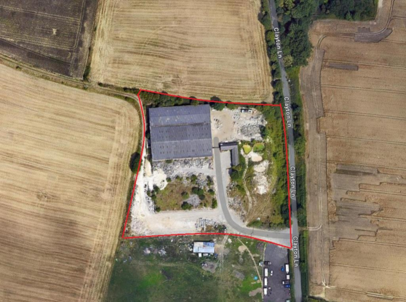
Potential Residential Development Site, Clayton Lane, Thurnscoe, Sheffield
£4.88 per sq ft
Business rates & charges may apply

- SIZE AVAILABLE
174,240 sq ft
16,187 sq m
- SECTOR
Land for sale
Key features
- POTENTIAL RESIDENTIAL DEVELOPMENT SITE
- 4 ACRES (1.618 HECTARES)
- The site has been used for industrial purposes over recent years with industrial buildings extending to 2,415.46m² (26,000ft²).
- The site offers the potential for redevelopment, subject to planning, which was previously granted in 2008 for the erection of 24 dwellings.
- Well located 9 miles from Barnsley and accessible for Junction 38 of the A1(M) motorway network.
- EPC - C Rating
Description
Currently the site benefits from 2 adjoining single storey industrial buildings which are constructed of brick under pitched corrugated asbestos sheet covered roofs and a single storey former office and staff welfare block which is of brick construction
The site offers the potential for residential development, with planning having previously been granted in 2008 for the erection of 24 dwellings.
Brochures
Potential Residential Development Site, Clayton Lane, Thurnscoe, Sheffield

NEAREST STATIONS
Distances are straight line measurements from the centre of the postcode- Thurnscoe Station0.7 miles
- Goldthorpe Station1.1 miles
- Bolton-on-Dearne Station2.1 miles
Notes
Disclaimer - Property reference 33754692. The information displayed about this property comprises a property advertisement. Rightmove.co.uk makes no warranty as to the accuracy or completeness of the advertisement or any linked or associated information, and Rightmove has no control over the content. This property advertisement does not constitute property particulars. The information is provided and maintained by BRAMLEYS LLP, Huddersfield. Please contact the selling agent or developer directly to obtain any information which may be available under the terms of The Energy Performance of Buildings (Certificates and Inspections) (England and Wales) Regulations 2007 or the Home Report if in relation to a residential property in Scotland.
Map data ©OpenStreetMap contributors.