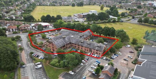

Civic Centre, Stone Cross, Northallerton, DL6 2UU

- SIZE AVAILABLE
6,676-47,940 sq ft
620-4,454 sq m
- SECTOR
Office for sale


Key features
- 2.00 acres (0.81 ha) Land in Central Northallerton
- 47,000 sq. ft. purpose built offices
- Considerable development potential (STPP)
- Beside Northallerton Leisure Centre
- Excellent transport routes
- Offers due before 1pm Friday 30th April 2025
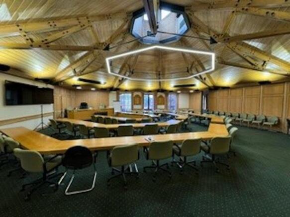
Description
The structure likely features a steel or concrete frame, with external walls constructed of red brick and glazing. The windows are typical of that era,
appearing to be either aluminum or steel-framed and generally rectangular in shape with bay windows at each staircase.
The area in which we believe can be demised to a new owner whilst maintaining appropriate access to and from the Leisure Centre equates to approximately 2.00 acres (0.81 ha).
The building currently benefits from circa 140 white-lined tarmacadam car parking spaces.
The subject property is located within the popular market town of Northallerton in North Yorkshire with its population of 13,308, an increase of 1.7% from 2011 when the population was around 89,100.
The town is near to the River Wiske in the Vale of Mowbray and serves as the administrative centre for York and North Yorkshire Combined Authority.
The property is located 21.60 miles (34.76 km) south of Middlesbrough with its population of 143,900 (2021 census), 16.00 miles (25.75 km) south of Darlington with its population of 107,800 (2021 census), 9.40 miles (15.13 km) north of Thirsk with its population of 4,998 (2011 census) and 9.50 miles (15.29 km) east of Bedale with its population of 3,285 (2021 census).
Northallerton is located between the A1(M) and A19, with Junction 51 being the closest, beside Leeming Bar Industrial Estate.
Brochures
Civic Centre, Stone Cross, Northallerton, DL6 2UU

NEAREST STATIONS
Distances are straight line measurements from the centre of the postcode- Northallerton Station1.1 miles
About Align Chartered Surveyors, Northallerton
White Rose House Northallerton Business Park, Northallerton, DL6 2NANotes
Disclaimer - Property reference 278342-1. The information displayed about this property comprises a property advertisement. Rightmove.co.uk makes no warranty as to the accuracy or completeness of the advertisement or any linked or associated information, and Rightmove has no control over the content. This property advertisement does not constitute property particulars. The information is provided and maintained by Align Chartered Surveyors, Northallerton. Please contact the selling agent or developer directly to obtain any information which may be available under the terms of The Energy Performance of Buildings (Certificates and Inspections) (England and Wales) Regulations 2007 or the Home Report if in relation to a residential property in Scotland.
Map data ©OpenStreetMap contributors.