Land adj. Fishers Farm, Delph Lane, Charnock Richard, PR7 5ND
- PROPERTY TYPE
Land
- SIZE
553,212 sq ft
51,395 sq m
Key features
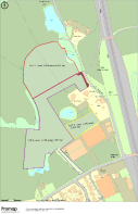
- * Three parcels of grassland totalling about 12.7 acres (5 hectares)
- * Available in three lots or as a whole
- * Lot one extends to around 2.03 hectares (5.02 acres) - edged red on the plan
- * Lot two extends to around 2.48 hectares (6.13 acres) - edged purple on the plan
- * Lot 3 extends to around 0.5 hectares (1.24 acres) - edged yellow on the plan
- * Interest to amenity, equestrian and agricultural buyers
Description
in the village of Charnock Richard. The plots are easily
accessed from the A49 and are close to the M6.
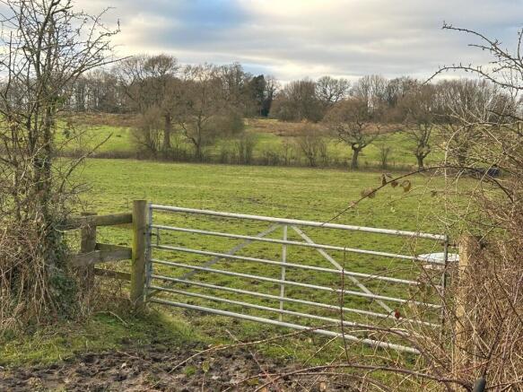
LAND DESCRIPTION
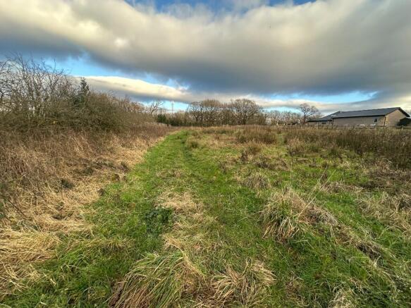
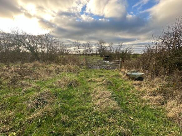
The land is split into three parcels separated to the west of
Delph Lane. The land is predominantly level and laid to grass.
Lots 1, 2 and 3 are designated as Grade 3 on MAFF Land
Classification Map of England & Wales. The soils are recorded
as slowly permeable, seasonally wet, slightly acid but base-rich
loamy and clayey. The land parcel is bordered by fences,
hedges and trees.
Lot 1 includes land in registry titles LA740364.
Lot 2 includes land in registry titles LA740364 and LA828950
Lot 3 includes land in registry titles LA828950
If the land is sold in three lots, purchasers of adjoining lots will
be jointly responsible for the cost of erecting a stockproof fence
and thereafter for its maintenance. The owners informed us that
the perimeter fencing was replaced 2/3 years ago. The land is
likely to require draining.
TENURE
All the land is freehold and offered with vacant possession on
completion. The land is currently occupied under a grazing
licence.
SERVICES
MacMarshalls Ltd have not tested any services and purchasers
should satisfy themselves as to their presence and working
condition prior to exchange of contracts.
PLANNING
The land is designated as Green Belt, within the Chorley Local
Plan (2012 to 2026) adopted in 2015.
LOCAL AUTHORITY
The local authority is Chorley Borough Council, Town Hall,
Market Street, PR7 1DP. .
RIGHTS OF WAY, EASEMENTS AND WAYLEAVES
The land is sold with the benefit of, and subject to, all
existing rights of way, easements and wayleaves.
Delph Lane is a public footpath, however none go through the
land parcels.
Lot 1 is sold subject to a right of way providing access to Lot 2
off Delph Lane. Lot 2 is sold with the benefit of a right of way
over the access area shown in brown on the location plan. This
plot also adjoins Church Lane. Lot 3 is sold without the benefit
of access to an adopted highway.
OVERAGE
The sale is subject to an overage clause. The total overage will
be at a rate of 50% of the uplift in value following the benefit and
implementation of planning consent for residential or commercial
development (non agricultural/equestrian) for a period of 50
years from the completion date.
BASIC PAYMENT SCHEME
No Basic Payment Scheme entitlements are included in the sale
as it is no longer possible to transfer them. The land has not been
entered into any environmental schemes.
METHOD OF SALE & GUIDE PRICE
Offers are invited for the whole and each lot individually. The land
is offered for sale by tender, tender date 14th March 2025.
Interested parties should complete the tender form and return it
to MacMarshall's office on or before 12 noon on 14th March
2025. Please place the tender form in a marked envelope
indicating the address for the land and tender date. Any offers
received in the marked envelopes will remain unopened until
after the tender time. No emailed or faxed tenders can be
accepted.
PROOF OF FUNDS
Proof of funds should also with any tender documents.
CLIENT DUE DILIGENCE
Any tender must be accompanied with certificated copies of two
forms of formal identification.
VIEWINGS
Please contact the agents to arrange a viewing. Site security
restricts access to unaccompanied viewers.
HEALTH & SAFETY
Prospective purchasers are respectfully reminded that they
should take all reasonable precautions when viewing the property
and observe necessary health and safety procedures (including
all up to date government guidance in respect of Covid-19).
Please take care in respect of any uneven ground. The vendors
for themselves, and MacMarshalls Ltd as their agents, accept no
liability for any health and safety issues arising out of viewing the
property.
AGENTS
Please contact either Sophie Marshall or Rob Mackenzie.
The information provided is for reference purposes only. The purchasers
shall have deemed to have satisfied themselves to the description of the
land and any error or mistake shall not annul the sale or entitle any party
to compensation in respect thereof. No warranty for the accuracy or any
information can be given.
Brochures
Sales ParticularsLand adj. Fishers Farm, Delph Lane, Charnock Richard, PR7 5ND

NEAREST STATIONS
Distances are straight line measurements from the centre of the postcode- Chorley Station2.0 miles
- Euxton Balshaw Lane Station2.2 miles
- Buckshaw Parkway2.5 miles
About MacMarshalls, Bolton
Hamill House, 112-116 Chorley New Road, Bolton, BL1 4DH
Notes
Disclaimer - Property reference C702-2. The information displayed about this property comprises a property advertisement. Rightmove.co.uk makes no warranty as to the accuracy or completeness of the advertisement or any linked or associated information, and Rightmove has no control over the content. This property advertisement does not constitute property particulars. The information is provided and maintained by MacMarshalls, Bolton. Please contact the selling agent or developer directly to obtain any information which may be available under the terms of The Energy Performance of Buildings (Certificates and Inspections) (England and Wales) Regulations 2007 or the Home Report if in relation to a residential property in Scotland.
Map data ©OpenStreetMap contributors.