Llandeilo Road, Gorslas, Llanelli

- PROPERTY TYPE
Land
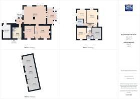
- BEDROOMS
4
- BATHROOMS
2
- SIZE
153,767 sq ft
14,285 sq m
Key features
- Traditionally Built, Immaculately Presented, Detached House
- Four Double Bedrooms
- Three Reception Rooms & Sunroom
- Cloakroom & Upstairs Shower Room & Bathroom
- Total Plot Measures 4.076 Acres
- Stable Block With Two Stables & Tack Room
- Land Measures 3.527 Acres
- Viewing Highly Recommended for the Size, Location & Presentation
- EPC RATING E. COUNCIL TAX BAND E.
Description
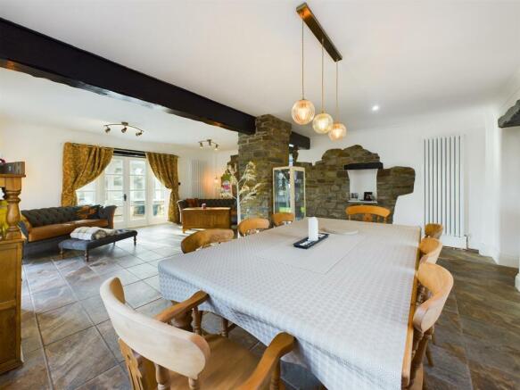
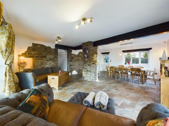
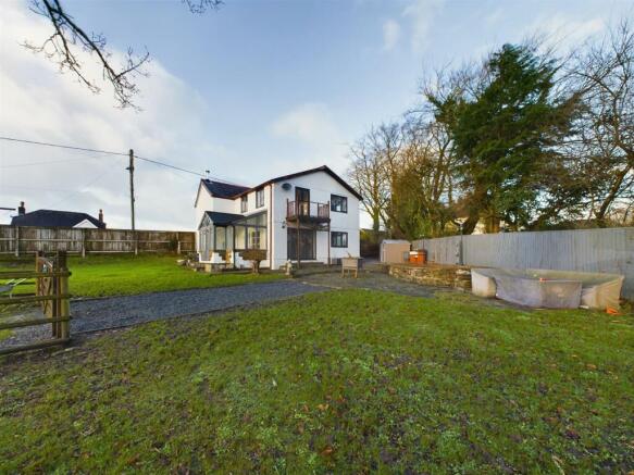
Accommodation comprises: Lounge with log-burner, sitting room, spacious dining/family room, sunroom, boot-room, kitchen, cloakroom, landing bathroom, shower-room and four double bedrooms. The property sits in a spacious plot with ample parking and lawn and patio gardens. The remainder of the plot boasts a stable block that houses two stables, a tack room, and a menage. The remainder of the land measures roughly 3.527 acres. The total size of the plot measures 4.076 acres.
The village of Gorslas offers essential amenities with out-of-town retailers at Crosshands Business Park. A convenient location with easy access to the M4 motorway and link roads via the dual carriageway with a connection at Crosshands.
..Agents Viewing Notes - *** KEY INFORMATION *** Traditionally built. Mains water, electricity and sewerage are connected—oil central heating (boiler fitted 2024). There are covenants and easements on the title, which we have on file; please request a copy for your information. The plot size measures 4.076 acres, and the land measures 3.527 acres (measured by Promap 20/12/24). There are three gentle downward-sloping paddocks along the lower boundary with a stream. The vendors have a private agreement to graze their horses on neighbouring Council land, which adjoins the property. A proportion of the land is subject to SSSI designation (Site of Special Scientific Interest), a written agreement with NRW (Natural Resources Wales) for land maintenance - for example, restricted grazing rights during winter periods. The Local Authority also replaced most of the stock fencing to the perimeter of the land connected with the property cut back, removed all scrub, and installed a water trough for horses. The local authority consulted NRW before finalising the menage. A SUDS application for approval of the drainage scheme for the menage is pending approval per Council planning requirements. For this location, according to Offcom, this is the following information: Broadband availability- up to Ultrafast (1800 Mpbs), Mobile availability coverage for 02 and Vodaphone, limited mobile coverage for EE and Three. Based on the information currently available to the Coal Authority, a mining report is recommended for this property.
Main House -
Lounge -
Office/Sitting Room -
Dining & Family Room -
Sunroom -
Boot Room -
Kitchen -
Cloakroom -
Landing -
Bathroom -
Shower Room -
Bedroom 1 -
Bedroom 2 -
Bedroom 3 -
Bedroom 4 -
External Utility Room -
Stable Block : -
Stable 1 -
Stable 2 -
Tack Room -
Manege -
Brochures
Llandeilo Road, Gorslas, LlanelliBrochureEnergy Performance Certificates
EE RatingLlandeilo Road, Gorslas, Llanelli

NEAREST STATIONS
Distances are straight line measurements from the centre of the postcode- Llandybie Station2.9 miles
- Ammanford Station3.2 miles
- Pantyffynnon Station3.7 miles

Notes
Disclaimer - Property reference 33576398. The information displayed about this property comprises a property advertisement. Rightmove.co.uk makes no warranty as to the accuracy or completeness of the advertisement or any linked or associated information, and Rightmove has no control over the content. This property advertisement does not constitute property particulars. The information is provided and maintained by West Wales Properties, Ammanford. Please contact the selling agent or developer directly to obtain any information which may be available under the terms of The Energy Performance of Buildings (Certificates and Inspections) (England and Wales) Regulations 2007 or the Home Report if in relation to a residential property in Scotland.
Map data ©OpenStreetMap contributors.