Land at Lower Bordean, GU32 1ER - The Whole

- PROPERTY TYPE
Land
- SIZE
1,357,330 sq ft
126,100 sq m
Key features
- SEE AND PRINT PDF SALES PARTICULARS AVAILABLE BELOW
- SEE DRONE VIDEO FOOTAGE ON THE VIRTUAL TOUR TAB
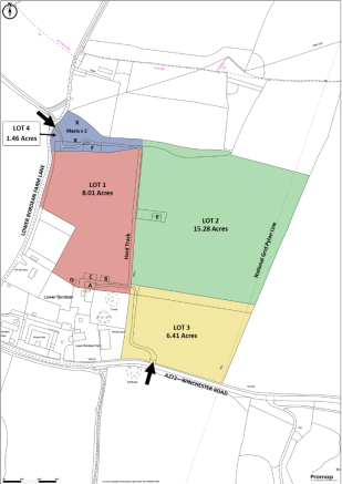
- APPROX. 31.16 ACRES IN ALL
- AVAILABLE AS A WHOLE OR IN UP TO 4 LOTS
- TWO TELECOMMUNICATION MASTS
- AGRICULTURAL BUILDINGS (Approx. 1,096m²/11,768ft²)
- PASTURE/AMENITY LAND (Approx. 27.20 acres)
- MATURE SPRUCE PLANTATION AND WOODLAND (Approx. 2.04 Acres)
- WITHIN THE SOUTH DOWNS NATIONAL PARK
- FRONTAGE ONTO THE A272 AND LOWER BORDEAN FARM LANE
Description
For Sale as a Whole, or in up to 4 Lots. Offers Invited.
Freehold For Sale - vacant no chain
VIEWING INSTRUCTIONS: Pedestrian access can be gained to the Property from the access off Lower Bordean Farm Lane. On foot unaccompanied and only during daylight hours, taking a set of these Sales Particulars with you. It is essential to view the drone video footage available at the website
VIDEO DRONE FOOTAGE: See the website and further details, photographs and drone video footage is available showing the whole Property.
LOCATION: See Location Plan. Postcode: GU32 1ER. Access - What3Words: Property is located at Lower Bordean in the parish of Langrish. Lower Bordean is a small hamlet of around a dozen residential properties, situated adjacent to the A272.
DIRECTIONS: The Property is positioned around 3 miles to the west of Petersfield, with frontage onto the A272. From the A3 junction at Petersfield, it is around 2.9 miles west along the A272. From the junction of the A32 with the A272 it is around 3.3 miles east along the A272. The recommended access for viewing the Property is off Lower Bordean Farm Lane around 0.25 miles north of the A272. Lower Bordean Farm Lane joins the A272 at Lower Bordean. Please use the Postcode and What3Words as stated in the 'Location' above and the Location Plan.
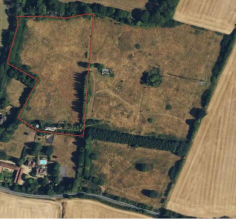
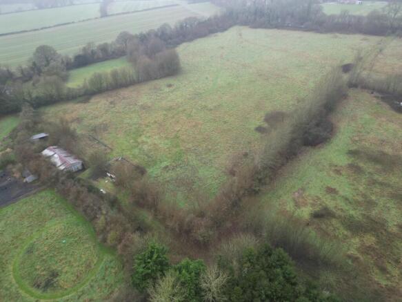
DESCRIPTION: The Property extends in all to approximately 31.16 acres, as coloured on the Site Plan. It comprises one agricultural building, two old chicken sheds generally in a poor state of repair, a field shelter, two old polytunnel frames, two telecommunications masts under leases at the north-western corner of the Property, approx. 0.4 miles of hardstanding trackways, approx. 0.77 acres of mature spruce plantation, approx. 1.27 of mature broadleaf woodland and approx. 27.20 acres of pastureland. The whole is bounded by fences and established hedgerows.
The Property has road frontage onto the A272 along part of the southern boundary and onto Lower Bordean Farm Lane along part of the western boundary. There are several residential properties adjacent to the Property at the south-western corner. There are two accesses to the Property including one off the A272 which is currently out of use. The other access is off Lower Bordean Farm Lane at the north-western corner. These accesses are indicated by the arrows on the Site Plan.
The current owner acquired the Property in 1995 and since then it has been in a number of uses including calf rearing which ceased around 18 years ago, chicken farming (egg production) and also horse grazing. The horses left around 7 years ago and since this point the Property has only been in occasional amenity use.
The Property is available For Sale as a Whole or in a combination of up to 4 Lots - See Site Plan. The Lots are marked on the ground with pegs and paint.
TELECOMS MASTS: There are currently two telecommunications masts on the Property at the positions marked X on the Site Plan. These are managed by different operators (EE and Airway/O2). The rents on both masts have been reviewed recently in line with the new Telecommunications Code and reduced substantially. The access off Lower Bordean Farm Lane has been split and an area of hardstanding has been laid to provide a parking area for personnel accessing the masts.
EE Mast - 7 years left on Lease. Rent currently £600 per annum.
Airway/O2 - In the process of being renewed. Rent agreed at £2000 per annum.
Please see Additional Documents for Copies of the Leases from Land Registry.
LAND: According to the Agricultural Land Classification, the entirety of the Property is Grade 3 defined as land with moderate limitations that affect the choice of crops, timing and type of cultivation, harvesting or the level of yield. The Geological Survey Map indicates that the Property lies within an area of shallow lime-rich soils over chalk or limestone. The land has a southerly aspect with a gentle slope down towards the A272 from around 180m above sea level to around 150m.
LAND REGISTRY TITLE: The Property consists of the entirety of Land Registry Titles HP359304 and HP531036. Please see Additional Documents for Copies of Register and Plan.
PLANNING/PLANNING HISTORY: The Property is within the South Downs National Park Planning Area and their Local Plan shows it to be in an area of 'Countryside' outside of settlement boundaries. South Downs Parkwide Local Plan policies apply.
The only recent planning application relating to the Property relates to the telecommunication masts.
25th August 2017: SDNP/17/03408/TEL. Prior notification of proposed development by telecommunications code system operators - replacement of 3 no. antennas mounted to new brackets off spine and the installation of an equipment cabinet to existing lower base along with ancillary development thereto.
Please see Additional Documents for Copies of the Site Plan and Decision Notice.
DESIGNATIONS: The Property is within the South Down National Park and it also straddles the boundary between the Hampshire Downs and Wealden Greensand National Character Areas. There is a Scheduled Ancient Monument comprising two barrows on land adjacent to the Property. This Scheduled Monument is immediately to the north-east of Lower Bordean Farm.
PUBLIC FOOTPATHS: No public footpaths or bridleways cross the Property.
SERVICES: Historically the Property benefitted from mains electricity and water supplies. These supplies likely remain available if not connected.
RIGHTS AND RESTRICTIONS: The Property is affected by a National Grid Pylon Line that passes up the eastern boundary of the Property with a pylon situated halfway up Lot 2. There are associated wayleave/easement rights as is usually the case with such pylon lines. There are other rights and restrictions referred to on both the Land Registry Title Registers - please see Additional Documents for Land Registry Documentation.
BUSINESS RATES: None currently demanded.
EAST HAMPSHIRE DISTRICT COUNCIL: East Hampshire Council Offices, Penns Place, Petersfield, GU31 4EX. Tel: .
PLANNING AUTHORITY: South Downs National Park Authority (SDNP), South Downs Centre, North Street, Midhurst, West Sussex, GU29 9DH. Tel: .
BIODIVERSITY NET GAIN (BNG): There may be the potential for parts of the Property to be managed in a way, or with new habitats established, to be suitable for use as part of the new requirement for development to provide a 10% biodiversity net gain. Such BNG Credits can then be sold to developers.
OFFER INSTRUCTIONS: Please see the Additional Document on our website for instructions as to how to make an offer by Private Treaty.
Brochures
Sales ParticularsLand at Lower Bordean, GU32 1ER - The Whole

NEAREST STATIONS
Distances are straight line measurements from the centre of the postcode- Petersfield Station3.2 miles
About Giles Wheeler-Bennett, Southampton
West Court, Lower Basingwell Street, Bishop's Waltham, SO32 1AJ
Notes
Disclaimer - Property reference LowerBordeanWhole. The information displayed about this property comprises a property advertisement. Rightmove.co.uk makes no warranty as to the accuracy or completeness of the advertisement or any linked or associated information, and Rightmove has no control over the content. This property advertisement does not constitute property particulars. The information is provided and maintained by Giles Wheeler-Bennett, Southampton. Please contact the selling agent or developer directly to obtain any information which may be available under the terms of The Energy Performance of Buildings (Certificates and Inspections) (England and Wales) Regulations 2007 or the Home Report if in relation to a residential property in Scotland.
Map data ©OpenStreetMap contributors.