Reach, Cambridgeshire, CB25

- PROPERTY TYPE
Equestrian Facility
- SIZE
Ask agent
- TENUREDescribes how you own a property. There are different types of tenure - freehold, leasehold, and commonhold.Read more about tenure in our glossary page.
Ask agent
Description
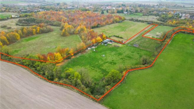
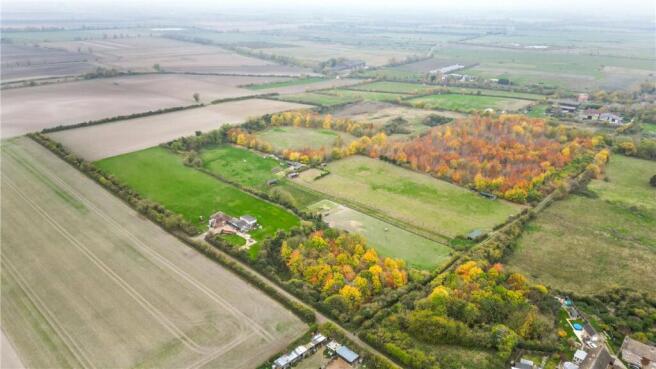
Grazing land and buildings located in a tranquil and private setting on the outskirts of Reach, Cambridge.
In all extending to 3.18 acres (1.29 hectares).
For sale by Private Treaty as a whole.
Please register with the Agent to view the Property.
Property
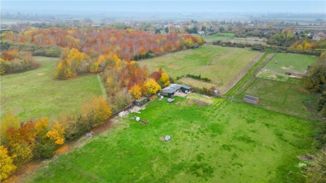
Located within a former chalk clunch pit, the Property offers secure and private grazing land comprising Grade 2 soils.
The Property comprises 2.63 acres of well-drained grazing land secured by timber post-and-rail, and post-and-wire fencing. There is an additional 0.33-acre paddock that provides separate grazing with the benefit of two stables, which could also be utilised as a field shelter.
Within the main paddock are two large timber-framed stables, a large hay and feed room and a lean-to machinery store. The Property is secured by a timber five-bar gate as well as a pedestrian gate. The track from the access to the paddocks offers additional grazing. The land is accessed via a public byway directly off Green Lane.
Location
Reach is a small village 2 km west of Burwell, 14 km north-east of Cambridge and 8 km north-west of Newmarket.
The Property is connected to the surrounding areas by three principle roads, the B1102, A14 and A142. Newmarket train station (8 km) provides direct rail links to Cambridge and Bury St Edmunds in under 40 minutes, and to London in under 2 hours.
Access
The Property is accessed via a public byway which runs between Fair Green via Clunch Pit Lane to Green Lane. This is also known as Earthworks Way.
Services
There are no services connected to the Property. There is a rainwater-harvesting tank adjacent to the stables.
Tenure
The freehold of the site is offered for sale with Vacant Possession.
Wayleaves, Easements & Rights of Way
The Property is to be sold subject to, and with the benefit of, all existing wayleaves, easements, covenants and rights of way, whether or not disclosed.
Health & Safety
All viewings are carried out at the sole risk of the viewer and neither the selling agent nor the Vendor takes responsibility.
VAT
Any guide prices quoted or discussed are exclusive of VAT.
In the event that the sale of the Property becomes a chargeable supply for the purposes of VAT, such tax will be payable (or become payable by the purchaser) in addition to the purchase price.
Sporting, Timber & Mineral Rights
To be included in the sale.
Local Authority
East Cambridgeshire District Council
The Grange Car Park
Nutholt Lane
Ely
CB7 4EE
Viewings
Viewings of the Property are to be accompanied, arranged via the selling agent.
Directions
From A14: Take exit 35 off the A14 to join the B1102. Continue for 8.30 km before turning left onto Rogers Road. Turn left onto Swaffham Road and then turn right onto Green Lane. Continue for 180m before turning right onto a public byway. The Property will be on your left-hand-side. The land can also be accessed via Clunch Pit Lane, opposite the pub on the village green.
What3Words
/// blink.litigate.latches
Carter Jonas Contacts
Jasmine Holland
Jamie Elbourn
Brochures
Particulars- COUNCIL TAXA payment made to your local authority in order to pay for local services like schools, libraries, and refuse collection. The amount you pay depends on the value of the property.Read more about council Tax in our glossary page.
- Band: TBC
- PARKINGDetails of how and where vehicles can be parked, and any associated costs.Read more about parking in our glossary page.
- Yes
- GARDENA property has access to an outdoor space, which could be private or shared.
- Yes
- ACCESSIBILITYHow a property has been adapted to meet the needs of vulnerable or disabled individuals.Read more about accessibility in our glossary page.
- Ask agent
Energy performance certificate - ask agent
Reach, Cambridgeshire, CB25

Add an important place to see how long it'd take to get there from our property listings.
__mins driving to your place
Your mortgage
Notes
Staying secure when looking for property
Ensure you're up to date with our latest advice on how to avoid fraud or scams when looking for property online.
Visit our security centre to find out moreDisclaimer - Property reference CBR240051. The information displayed about this property comprises a property advertisement. Rightmove.co.uk makes no warranty as to the accuracy or completeness of the advertisement or any linked or associated information, and Rightmove has no control over the content. This property advertisement does not constitute property particulars. The information is provided and maintained by Carter Jonas LLP - Rural, Cambridge. Please contact the selling agent or developer directly to obtain any information which may be available under the terms of The Energy Performance of Buildings (Certificates and Inspections) (England and Wales) Regulations 2007 or the Home Report if in relation to a residential property in Scotland.
*This is the average speed from the provider with the fastest broadband package available at this postcode. The average speed displayed is based on the download speeds of at least 50% of customers at peak time (8pm to 10pm). Fibre/cable services at the postcode are subject to availability and may differ between properties within a postcode. Speeds can be affected by a range of technical and environmental factors. The speed at the property may be lower than that listed above. You can check the estimated speed and confirm availability to a property prior to purchasing on the broadband provider's website. Providers may increase charges. The information is provided and maintained by Decision Technologies Limited. **This is indicative only and based on a 2-person household with multiple devices and simultaneous usage. Broadband performance is affected by multiple factors including number of occupants and devices, simultaneous usage, router range etc. For more information speak to your broadband provider.
Map data ©OpenStreetMap contributors.