Ffair Rhos, Ystrad Meurig, SY25

- PROPERTY TYPE
Farm Land
- SIZE
Ask agent
Key features
- FFAIR RHOS
- Appealing parcel of land
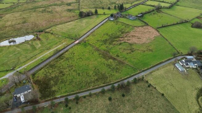
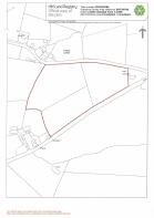
- Approx 5.625 acres
- Split into three manageable paddocks
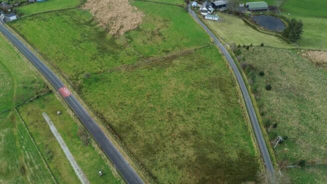
- Well fenced
- Level to sloping in nature
- Perfect for Animal keeping
- Surrounded by magnificent views
Description
*** A highly appealing and sought after parcel of land *** Extending in total to approximately 5.625 acres *** Split into three manageable paddocks *** Well fenced with two roadside gated access points *** Level to sloping in nature *** Surrounded by magnificent views over the renowned Teifi Valley and Cambrian Mountains
*** Versatile land suiting a range of uses *** Perfect for Animal keeping - Sheep, Cattle and Horse grazing *** Or for alternative use such as potential Animal grazing, lifestyle or tourism venture (subject to the necessary consent being granted) *** The parcel enjoys an elevated position with far reaching views
*** Centre of Ffair Rhos *** 1 mile to the popular Village Community of Pontrhydfendigaid *** Close to the Market Towns of Lampeter and Tregaron and the University Town of Aberystwyth
To be confirmed.
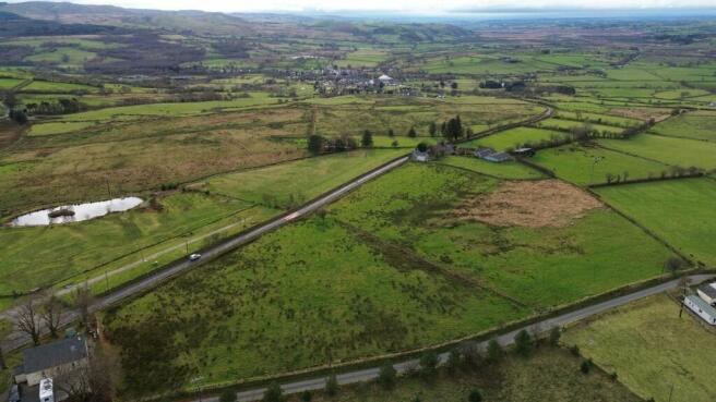
LOCATION
The land lies within the rural settlement of Ffair Rhos which boasts a popular Public House. The larger Village of Pontrhydfendigaid lies within a mile of the parcel of land with a range of facilities including Village Shop, Post Office, Public Houses, Primary School, good Leisure facilities, large Community Hall and good Public Transport connectivity. The Market Town of Tregaron with its Comprehensive School and a wider range of day to day needs is a 10 minute drive from the property. The University Town Coastal Resort and Administrative Centre of Aberystwyth with its regional Bronglais Hospital, National Library, Council and Welsh Government Offices lies within a 30 minute drive from the land.
GENERAL DESCRIPTION
A well positioned convenient parcel of land of approximately 5.625 acres is a convenient parcel split into three paddocks being well fenced and having two roadside access points. It enjoys an elevated position within the rural Community of Ffair Rhos and boasts magnificent views over the Cambrian Mountains and the Teifi Valley. The property suits a range of uses for Animal grazing, lifestyle or potential tourism venture (subject to consent).
Viewing is highly recommend. A rare and unrivalled opportunity. A convenient parcel of land within a Village.
FIRST IMAGE
SECOND IMAGE
THIRD IMAGE
TENURE ANDPOSSESSION
We are informed the property is of Freehold Tenure and will be vacant on completion.
MONEY LAUNDERING REGULATIONS
The successful Purchaser will be required to produce adequate identification to prove their identity within the terms of the Money Laundering Regulations. Appropriate examples include Passport/Photo Driving Licence and a recent Utility Bill. Proof of funds will also be required or mortgage in principle papers if a mortgage is required.
WEBSITE
All properties are available to view on our Website – on our FACEBOOK Page - 'LIKE' our FACEBOOK Page for new listings, updates, property news and ‘Chat to Us’.
To keep up to date please visit our Website, Facebook and Instagram Pages
Brochures
Brochure 1Ffair Rhos, Ystrad Meurig, SY25

NEAREST STATIONS
Distances are straight line measurements from the centre of the postcode- Bow Street Station12.5 miles


Notes
Disclaimer - Property reference 28315509. The information displayed about this property comprises a property advertisement. Rightmove.co.uk makes no warranty as to the accuracy or completeness of the advertisement or any linked or associated information, and Rightmove has no control over the content. This property advertisement does not constitute property particulars. The information is provided and maintained by Morgan & Davies, Lampeter. Please contact the selling agent or developer directly to obtain any information which may be available under the terms of The Energy Performance of Buildings (Certificates and Inspections) (England and Wales) Regulations 2007 or the Home Report if in relation to a residential property in Scotland.
Map data ©OpenStreetMap contributors.