
Approximately 43.49 acres of Land, North of Glyncoli Farm, Treorchy

- PROPERTY TYPE
Land
- SIZE
Ask agent
Key features
- Approximately 43.49 acres of land
- Rural Location
- Unique opportunity
- For sale by Private Treaty
- Natural Water Supply
Description
The land is situated directly to the north of Treorchy. The land is a short travelling distance from Treorchy, Tonypandy & Porth providing convenient amenities as well as good transport links. Please see the attached location plan.
Description
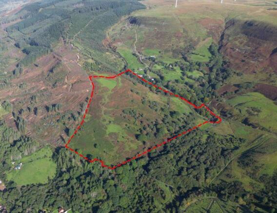
The property as a whole extends to approximately 43.49 acres of gently sloping or steep pasture land and woodland as edged red on the attached site plan.
Lot 1:
Shown edged red and extending to 6.84 acres, or thereabouts. The land borders the adopted highway to the east. Included in the total area is approximately 4.29 acres of woodland.
Lot 2:
Shown edged purple and extending to 36.64 acres or thereabouts of steep permanent pasture and woodland.
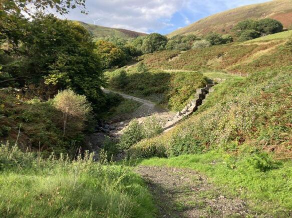
The land would benefit from land management as it is overgrown with fern, briars and trees but offers biodiversity and potential access to public money for public goods schemes
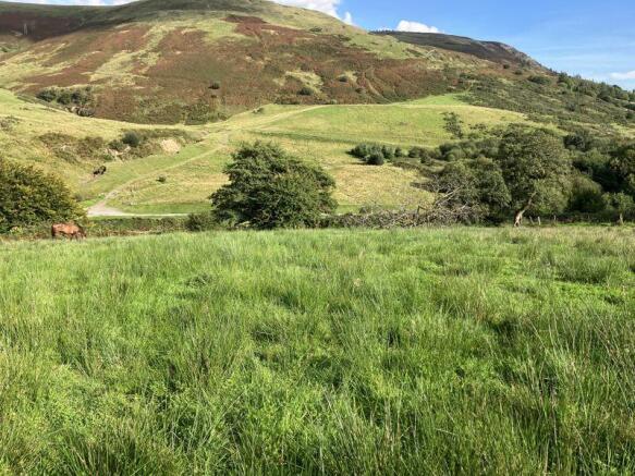
The land is suitable for grazing purposes with potential considered for agricultural, equestrian and amenity use.
The land also benefits from a natural water supply along its North Eastern boundary.
Approximately 13.90 acres of the land is identified as a Site of Importance for Nature Conservation (SINC). Of the 13.90 acres, approximately 2.57 acres is designated as Ancient Woodland, comprising of Oak and Birch Trees. Please refer to RCT Adopted Local Development Plan for more information. Adopted Local Development Plan Link:
The area shown hatched blue on the attached plan runs with the subject land but is not registered.
However, the land benefits from a prescribed Right of Way across the area hatched blue.
We are aware that the property does currently have Himalayan balsam.
Access
Access to the land is currently from a field gate off Cemetery Road.
Access points are marked ‘A’ on the attached plan.
In the event that the land is sold in two lots, the purchaser of Lot 1 (red) shall be responsible to erect and install an agricultural gate.
Plan
The plans attached to these particulars are shown for identification purposes only and, whilst every care has been taken, its contents cannot be guaranteed.
Services
The land benefits from a natural water supply.
Wayleave/Easements/Rights of Way
The property is being sold subject to and with the benefit of all rights including: rights of way, whether public or private, light, support, drainage, water and electricity supplies and other rights and obligations, easements and quasi-easements and restrictive covenants and all existing and proposed wayleaves for masts, pylons, stays, cables, drains, water and gas and other pipes whether referred to in these particulars or not. There is one footpath crossing the property along the Southern Boundary in a West to East direction.
Boundaries
The purchaser(s) shall be deemed to have full knowledge of all boundaries and neither the vendor nor the vendors agents will be responsible for defining the boundaries of the ownership thereof.
Basic Payment Scheme
The land is being sold without the benefit of Basic Payment Scheme Entitlements.
Tenure and Possession
Freehold with Vacant Possession upon completion.
Guide Price
Guide Price of £100,000 for the whole
Lot 1: £23,000
Lot 2: £77,000
Health and Safety
Given the potential hazards of agricultural land we ask you to be as vigilant as possible when making your inspection for your own personal safety. Nb: There are currently mares with foals at foot on the land.
Method of Sale
The property is offered for sale by Private Treaty.
Please contact Emily Flint or Elliott Rees for more information
/
/
Directions
Postcode: CF42 6TU
From Ysbyty Cwm Rhondda Hospital. Head northwest on Partridge Road/A4058 for 3.1 miles. Continue onto High Street/A4061. In 0.3 miles, turn right onto Cemetery Road. Continue for 0.3 miles, pass the Cemetery on your right hand side. Continue for 0.2 miles, cross the cattle grid and the land is located on your left-hand side.
Brochures
Property BrochureFull DetailsSite PlanApproximately 43.49 acres of Land, North of Glyncoli Farm, Treorchy

NEAREST STATIONS
Distances are straight line measurements from the centre of the postcode- Ynyswen Station0.7 miles
- Treorchy Station1.0 miles
- Treherbert Station1.2 miles


Notes
Disclaimer - Property reference 12164965. The information displayed about this property comprises a property advertisement. Rightmove.co.uk makes no warranty as to the accuracy or completeness of the advertisement or any linked or associated information, and Rightmove has no control over the content. This property advertisement does not constitute property particulars. The information is provided and maintained by Herbert R Thomas, Cowbridge. Please contact the selling agent or developer directly to obtain any information which may be available under the terms of The Energy Performance of Buildings (Certificates and Inspections) (England and Wales) Regulations 2007 or the Home Report if in relation to a residential property in Scotland.
Map data ©OpenStreetMap contributors.