Land at Clutton Hill, BS39
Business rates & charges may apply

- SIZE
Ask agent
- SECTOR
Land for sale
Key features
- Strategic Investment Land
- Shared Access
- Agricultural Pastureland
Description
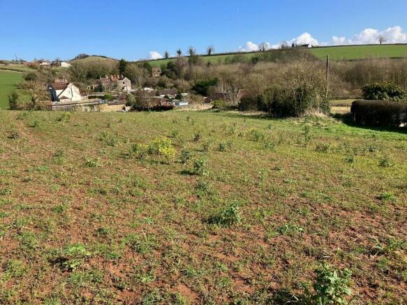
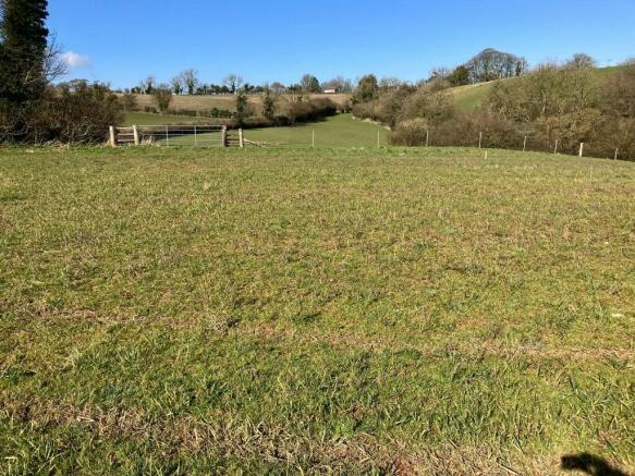
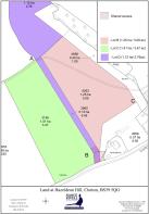
A unique opportunity to purchase 6.56 acres as a whole of agricultural pastureland or in 2 lots.
Lot B- 3.09 acres as shown in pink on the plan Guide Price £30,000
Lot C- 3.47 acres as shown in green on the plan Guide Price £35,000
Location
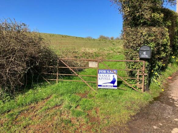
The Land has direct access from Clutton Hill.
What 3 Words
///mavericks.cloaks.handlebar
Right of Way
There is a public footpath which runs through Lot B & along the northern boundary of Lot C.
Designation
Shared access is granted over the RED hatched area as shown on the plan & access is to be improved by mutual agreement.
Tenure
Freehold with Vacant possession.
Local Authority
Bath & North East Somerset
Viewings
Strictly and only by prior appointment through the Vendors Sole Agents Nancekivell & Partners Limited either Richard Nancekivell or Chloe Brown .
Prior to making an appointment we strongly recommend that you discuss any queries you may have which are likely to affect your interest in the property in order that you do not make a wasted journey.
Special Conditions
Agents Fee
There is a £2,000 plus VAT Buyers fee payable to the auctioneers upon completion.
Important Notice
Nancekivell & Partners, their clients and any joint agents give notice that (1) They are not authorised to make or give any representation or warranties in relation to the property either here or elsewhere, either on their own behalf or on behalf of their client or otherwise.
They assume no responsibility for any statement that may be in these particulars.
These particulars no for form part of any offer or contract and must not be relied upon as statements or representation of fact.
(2) Any areas, measurements or distances are all approximate. The text, photographs and plans are for guidance only and are not necessarily all comprehensive.
It should not be assumed that the property has all the necessary planning, building regulation or other consents and Nancekivell & Partners Limited have not tested any services, equipment or facilities.
Purchasers must satisfy themselves by inspection or otherwise.
Brochures
Land at Clutton Hill, BS39

NEAREST STATIONS
Distances are straight line measurements from the centre of the postcode- Keynsham Station5.9 miles
About NANCEKIVELL & PARTNERS LTD, Wrington
South Cottage Office Long Lane, Wrington, BS40 5SA
Notes
Disclaimer - Property reference CurtisA. The information displayed about this property comprises a property advertisement. Rightmove.co.uk makes no warranty as to the accuracy or completeness of the advertisement or any linked or associated information, and Rightmove has no control over the content. This property advertisement does not constitute property particulars. The information is provided and maintained by NANCEKIVELL & PARTNERS LTD, Wrington. Please contact the selling agent or developer directly to obtain any information which may be available under the terms of The Energy Performance of Buildings (Certificates and Inspections) (England and Wales) Regulations 2007 or the Home Report if in relation to a residential property in Scotland.
Auction Fees: The purchase of this property may include associated fees not listed here, as it is to be sold via auction. To find out more about the fees associated with this property please call NANCEKIVELL & PARTNERS LTD, Wrington on 01769 610377.
*Guide Price: An indication of a seller's minimum expectation at auction and given as a “Guide Price” or a range of “Guide Prices”. This is not necessarily the figure a property will sell for and is subject to change prior to the auction.
Reserve Price: Each auction property will be subject to a “Reserve Price” below which the property cannot be sold at auction. Normally the “Reserve Price” will be set within the range of “Guide Prices” or no more than 10% above a single “Guide Price.”
Map data ©OpenStreetMap contributors.