Land to the north-west of Buntingford, Ermine Street, Buntingford
- SIZE AVAILABLE
246,550 sq ft
22,905 sq m
- SECTOR
Land for sale
Key features
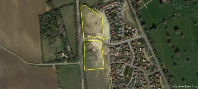
- The Property can be accessed from the A10 and Ermine Street
- A planning application has been approved for 58 residential units
- Unconditional offers are sought for the freehold interest with vacant possession
- Offers to be received by 12 noon on 1st November 2024
Description
The land to the east of the Property is defined by the Redrow Homes scheme comprising 180 residential units. The A10 runs along the western boundary of the Property with agricultural land to the north. The buildings associated with Freeman College are situated to the south. The land directly to the south of the Property is owned by Hertfordshire County Council and is retained for potential education and/or sports and recreation in association with Freeman College.
The Property is located within Buntingford Settlement Boundary. It is not located within a Conservation Area and there are no listed properties within close proximity. The Property is located in Flood Zone 1 and does not form part of any non-statutory wildlife designated sites. There are no Tree Preservation Orders affecting the Property.
The Property is located to the north of Buntingford, a town located in East Hertfordshire with good transport links to the south and east of the country. The town is located adjacent to the A10 which provides access to Royston and Cambridge to the north, and to south Hertfordshire and London to the south.
The nearby towns of Stevenage and Royston offer direct rail links into London in the shortest journey time of approximately 23 minutes.
Buntingford lies approximately 14.3 km (8.9 miles) north west of Bishop’s Stortford, 10.4 km (6.5 miles) east of Stevenage and 12.7 km (7.9 miles) east of Letchworth. The town has a resident population of 7,879 (2021 census).
The Property is considered to be in a highly sustainable area, being within a 15 minute walk of the town centre which benefits from a range of amenities including a variety of food and drink establishments, post office, primary and secondary schools and sports pitches.
Brochures
Land to the north-west of Buntingford, Ermine Street, Buntingford

NEAREST STATIONS
Distances are straight line measurements from the centre of the postcode- Ashwell & Morden Station6.3 miles
About Savills, Cambridge
Unex House, 132-134 Hills Road, Cambridge, CB2 8PA
Notes
Disclaimer - Property reference 6C4E0A91-8AAF-4B3A-A0E2-6BB78F3AA4FA. The information displayed about this property comprises a property advertisement. Rightmove.co.uk makes no warranty as to the accuracy or completeness of the advertisement or any linked or associated information, and Rightmove has no control over the content. This property advertisement does not constitute property particulars. The information is provided and maintained by Savills, Cambridge. Please contact the selling agent or developer directly to obtain any information which may be available under the terms of The Energy Performance of Buildings (Certificates and Inspections) (England and Wales) Regulations 2007 or the Home Report if in relation to a residential property in Scotland.
Map data ©OpenStreetMap contributors.