109.17 Acres Agricultural Land being part of Rhoslan Farm, Hayscastle, Haverfordwest
- PROPERTY TYPE
Farm Land
- SIZE
Ask agent
Key features
- PRICE GUIDES - Lot 1 from £560,000. Lot 2 from £340,000
- Fronting the Hayscastle Cross to Rhyndaston Council Maintained District Road, a valuable Block of Agricultural Land which extends to 109.17 Acres or thereabouts in total
- The majority of the Land is down to Clean Level Lying and Gently Sloping Pasture Land with the remainder being Second Quality Land and Rough Grazing Land which is bounded by a stream.
- The Land is either level lying or gently sloping with a south easterly aspect and is in the main is Sheep Fenced
- It benefits from a natural water supply although Mains Water is available in the vicinity of Hayscastle Cross and adjacent properties.
Description
Fronting the Hayscastle Cross to Rhyndaston Council Maintained District Road, a valuable Block of Agricultural Land which extends to 109.17 Acres or thereabouts in total of which the majority is down to
Clean Level Lying and Gently Sloping Pasture Land with the remainder being Second Quality Land and Rough Grazing Land which is bounded by a stream. The Land is either level lying or gently sloping with a south easterly aspect and is in the main is Sheep Fenced. It benefits from a natural water supply although Mains Water is available in the vicinity of Hayscastle Cross and adjacent properties. It is offered 'For Sale' in 2 Lots as follows:-
Lot 1 - 70.1358 Acres of Agricultural Land - Price Guide from £560,000
Lot 2 - 37.82 Acres Agricultural Land - Price Guide from £340,000
Situation - The Land concerned extends to 109.17 Acres or thereabouts and is situated within a third of a mile or so of the centre of the village of Hayscastle Cross.
Hayscastle Cross is bisected by the B4330 Haverfordwest to Croesgoch Road and is some 8 miles or so north west of the County and Market Town of Haverfordwest. The village has a number of Dwellings and a Public House.
The other well known village of Hayscastle is within a mile and a half or so and within 6 miles or so north west is the larger village of Croesgoch which has the benefit of a Primary School, Chapel, Public House/Post Office, a Repair Garage, Art Gallery and an Agricultural Store.
The other well known village of Letterston is within 4 miles or so and has the benefit of a Primary School, Public House/Restaurant, a Fish and Chip Shop Restaurant/Take-Away, a Petrol Filling Station/Store, a Church, Chapel, a Minik Market, Repair Garage, a Memorial/Community Hall, Butchers Shop/Post Office and a Charity Furniture Store.
The County and Market Town of Haverfordwest is within easy car driving distance and has the benefit of an excellent Shopping Centre together with an extensive range of amenities and facilities including Secondary and Primary Schools, Churches, Chapels, Banks, Building Societies, Hotels, Restaurants, Public Houses, Cafes, Take-Aways, Art Galleries, Petrol Filling Stations, Repair Garages, a Library, Post Office, a Further Education College, Supermarkets, The County Council Offices and The County Hospital at Withybush.
There are Livestock Markets at Whitland (within 22 miles or so) and Carmarthen (within 38 miles or so).
The North West Pembrokeshire Coastline at Porthgain is within 7 miles or so and also within easy reach are the other well known sandy beaches and coves on the north west Pembrokeshire Coastline Aber Felin, Abercastle, Abermawr, Aberbach, Traeth Llyfn, Abereiddy and on the north west and west Pembrokeshire Coastline at Whitesands Bay, Porthclais, Caerfai, Solva, Newgale, Broad Haven and Little Haven.
The other well known Market Town of Fishguard is some 10 miles or so north east whilst the Cathedral City of St Davids is some 9 miles or so south west.
Directions - From Haverfordwest, take the B4330 Road north west for some 8 miles or so and in the village of Hayscastle Cross, take the turning on left of the crossroads in the direction of Rhyndaston. Continue on this road for a third of a mile or so and the Land concerned is situated on the left hand side of the road. A "For Sale" Board is erected on site.
Alternatively from Fishguard, take the Main A40 Road south for some 5 miles passing through the village of Letterston and a third of a mile or so further on, take the turning on the right, signposted to Welsh Hook. Continue on this road for in excess of a mile or so and upon reaching the "T" junction, turn right and proceed through the hamlet of Welsh Hook and continue on this road for approximately 2 miles or so and upon reaching Hayscastle Cross and the crossroads with the B4330 Haverfordwest to Croesgoch Road, proceed straight across in the direction of Roch. Continue on this road for a third of a mile or so and the Land concerned is situated on the left hand side of the road. A "For Sale" Board is erected on site.
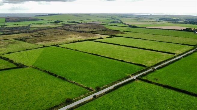
Description - The Land concerned is part of Rhoslan Farm and in total extends to 109.17 Acres or thereabouts. The Property will be offered "For Sale" by Private Treaty in 2 Lots as follows:-
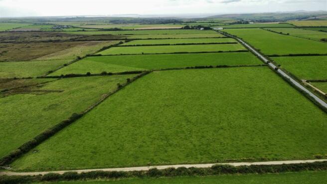
Lot 1 - 71.35 Acres of Agricultural Land which includes 45 Acres or thereabouts of predominantly clean, gently sloping Pasture Land with a southerly aspect. There are 3 enclosures which total 27 Acres or thereabouts of excellent quality, gently sloping Pasture Land, which have 3 field gate accesses onto the Council Road. Beyond is some 44 Acres or thereabouts of Pasture, Rough Grazing, Scrub and Amenity Land of which there is approximately 20 Acres of clean Pasture Land, whilst the remainder is Rough Grazing, Scrub and Amenity Land. There is a good natural water supply on the southern boundary and is in the main sheep fenced.
The boundaries of Lot 1 are edged in red on the attached Plan (Plan 1) to the Scale of 1/2500.
Adjoining Lot 1 is:-
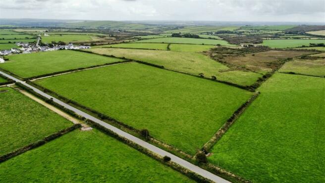
Lot 2 - 37.82 Acres or thereabouts of Agricultural Land. The Land concerned has frontage onto the Hayscastle Cross to Roch Council Maintained District Road and has a field gate access into O.S. No. 9998. Of the total acreage, there is in excess of 20 Acres of clean Pasture Land which is either level lying or gently sloping with a southerly aspect whilst the remaining 18 Acres or thereabouts is Rough Grazing/Amenity Land. The Land in the main is sheep fenced and has the benefit of a natural water supply on the southern boundary.
The boundaries of Lot 2 are edged in green on the attached Plan (Plan 2) to the Scale of 1/2500.
Services - There are no Services connected to the Land but we understand that Mains Water is available in the vicinity of adjacent properties in Hayscastle Cross and the Council Maintained Road leading from Hayscastle Cross in the direction of Roch.
Tenure - Freehold with Vacant Possession upon Completion.
Remarks - Rarely do block of Agricultural Land become available in this area and the opportunity to purchase should not be missed. In total, there is 109.17 Acres or thereabouts of Agricultural Land of which there is approximately 65 Acres of clean Pasture/Arable Land whilst the remaining 44 Acres or thereabouts can only be considered as Rough Grazing, Amenity and Scrub Land which is affected by Reeds. It is being offered "For Sale" in 2 Lots as follows:-
Lot 1 - 71.35 Acres of Agricultural Land
Lot 2 - 37.82 Acres of Agricultural Land.
Offers will be considered for the Land as 2 individual Lots or as an entity, i.e. 109.17 Acres. The Land is being offered "For Sale" in 2 Lots with realistic Price Guides and early inspection is strongly advised.
Lot 2 -
Lot 2 -
Lot 1 And 2 -
Lot 2 -
Lot 1 -
Brochures
109.17 Acres Agricultural Land being part of RhoslBrochure109.17 Acres Agricultural Land being part of Rhoslan Farm, Hayscastle, Haverfordwest

NEAREST STATIONS
Distances are straight line measurements from the centre of the postcode- Haverfordwest Station6.6 miles

Notes
Disclaimer - Property reference 33394331. The information displayed about this property comprises a property advertisement. Rightmove.co.uk makes no warranty as to the accuracy or completeness of the advertisement or any linked or associated information, and Rightmove has no control over the content. This property advertisement does not constitute property particulars. The information is provided and maintained by JJ Morris, Fishguard. Please contact the selling agent or developer directly to obtain any information which may be available under the terms of The Energy Performance of Buildings (Certificates and Inspections) (England and Wales) Regulations 2007 or the Home Report if in relation to a residential property in Scotland.
Map data ©OpenStreetMap contributors.