
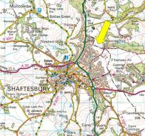
Wincombe, Shaftesbury

- PROPERTY TYPE
Land
- SIZE
993,168 sq ft
92,268 sq m
Key features
- Strategic edge of town location
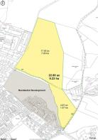
- 22.80 acres (9.23 hectares) of free draining agricultural land
- Abutting residential, commercial and agricultural land uses
- Significant development potential
- Overage clause at 20%
- Located in Dorset and Wiltshire
- For Sale by Private Treaty
Description
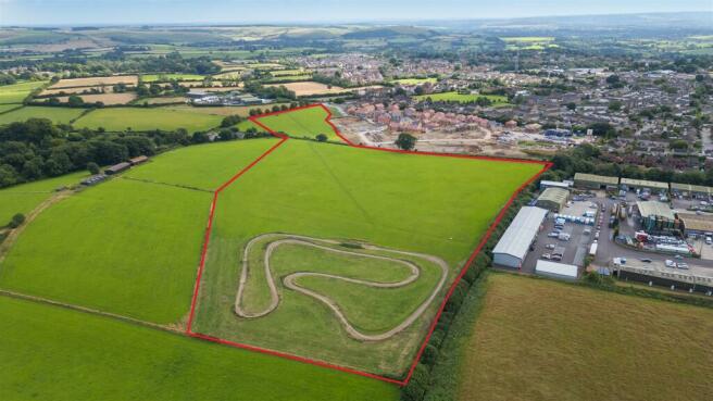
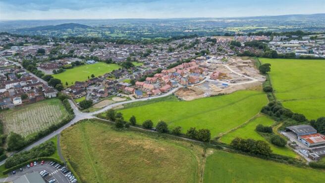
Location - The land is situated on the northern edge of Shaftesbury Town at the end of Wincombe Lane and is surrounded by a variety of land uses. Abutting the southern boundary is Niveus Walk, a residential development by David Wilson Homes of 162 dwellings currently under construction and to the southwest is Cranborne Drive, a housing development constructed in the 1970’s. Adjoining most of the western boundary is Wincombe Business Park, a modern industrial and commercial estate. To the north and east is open farmland. Beyond this is a recently developed solar park and off Wincombe Lane is the BV Dairy, a modern milk processing plant. The land undoubtably has potential for future development of one form or another, subject to planning consent.
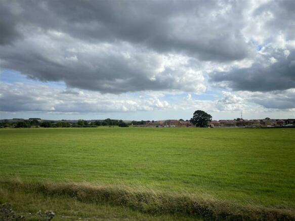
The land straddles the county boundary with the smaller southern field in Dorset and the larger northern field in Wiltshire. The land enjoys a pleasant view to the east overlooking farmland and woodland of the Cranborne Chase.
The Land - Two parcels of level and gently sloping productive pasture farmland. The soil is fertile and free draining upper greensand known as Boyne Hollow Chert. In the northern corner is a private dirt scramble track used by the current owner’s family. In additional to the development potential the land is equally suited to a range of agricultural, horticultural, equestrian and recreational uses.
Access - Access is off Wincombe Lane which serves as access to several housing developments, Shaftesbury Primary School, BV Dairy and a number of residential and agricultural properties at Higher Wincombe Farm. A section of the farm drive is included in the title. Additionally, as part of the neighbouring Niveus Walk development there is an access spur which could serve this land, subject to agreement.
Services - Both fields are connected to mains water via a submeter off Higher Wincombe Farm. Mains electricity is nearby.
Designations - A public footpath runs between the two parcels and a public bridleway runs along Wincombe Lane. The land is well connected to a network of bridleways, footpaths and a byway towards Semley and the Donheads. The land is in a Nitrate Vulnerable Zone but NOT in a National Landscape (formerly AONB).
Planning - We understand there have been no historical planning applications. Part of the land has been submitted to Dorset Council for consideration under the emerging local plan and previous call for sites exercise. The submission states Shaftesbury is one of the regions principal settlements with a focus for growth and new homes. The site is well located and adjacent to existing development and as such is a logical extension to the settlement. There is a school, shops and employment opportunities all within easy walking distances with the high street and supermarkets close by.
The existing North Dorset Local Plan seeks to retain a corridor for a possible bypass however this does not appear to have been carried over into draft local plans or the Wiltshire Local Plan and no contributions secured from neighbouring development.
Potential purchasers must rely on their own investigations of planning matters. The land is not being sold subject to obtaining planning permission.
There will be an overage covenant whereby the vendors and successors will be entitled to 20% of the uplift in value for a period of 25 years for the grant of planning consent for residential and commercial development.
Directions - From the Ivy Cross roundabout take the Longmead Road exit. Turn left at the crossroads into Wincombe Lane. Follow this pass the school and BV dairy entrance to the farm drive whereby the land entrance is on the left.
What3Words: ///soup.sharper.limelight
Viewing - Unaccompanied during daylight hours with a set of sales particulars in hand after informing the agents. Contact Andrew Tuffin on .
Brochures
Wincombe, ShaftesburyWincombe, Shaftesbury

NEAREST STATIONS
Distances are straight line measurements from the centre of the postcode- Gillingham (Dorset) Station4.3 miles

About Symonds & Sampson, Sturminster Newton
Agriculture House, Market Place, Sturminster Newton, DT10 1AR


Established in 1858, Symonds & Sampson's reputation is built on trust and integrity. Our aim is to provide individuals and businesses alike with high quality agency and professional services across residential, commercial and rural property sectors. Over 150 forward-thinking experts in our 16 regional offices will help you make the best decisions, ensuring that the buying, selling and managing of your most valuable asset is straight-forward and rewarding.
Notes
Disclaimer - Property reference 33380832. The information displayed about this property comprises a property advertisement. Rightmove.co.uk makes no warranty as to the accuracy or completeness of the advertisement or any linked or associated information, and Rightmove has no control over the content. This property advertisement does not constitute property particulars. The information is provided and maintained by Symonds & Sampson, Sturminster Newton. Please contact the selling agent or developer directly to obtain any information which may be available under the terms of The Energy Performance of Buildings (Certificates and Inspections) (England and Wales) Regulations 2007 or the Home Report if in relation to a residential property in Scotland.
Map data ©OpenStreetMap contributors.