


Bridgehampton, Yeovil, Somerset

- PROPERTY TYPE
Plot
- SIZE
Ask agent
Key features
- Residential Development Site
- Detailed Planning for seven (7) Residential Units
- 0.87 Acre Site (0.35-hectares)
- Further 1.1 Acre Field Available by Separate Negotiation Guide £40,000
- Planning Ref: 20/01206/FUL
- PHOSPHATE MITIGATION STRATEGY (In Place with Buyers Being Responsible for Implementation)
Description
The site extends, in total, to approximately 0.35-hectares (0.87-acres).
The field (to the south of the site) extends, in total, to approximately 0.46-hectares (1.13-acres). It is available by separate negotiation.
The Site - Residential development site with detailed planning permission for the erection of 7no. dwellings (all open market), together with associated infrastructure works.
The site extends, in total, to approximately 0.35-hectares (0.87-acres).
The field (to the south of the site) extends, in total, to approximately 0.46-hectares (1.13-acres). It is available by separate negotiation at a Guide Price of £40,000.
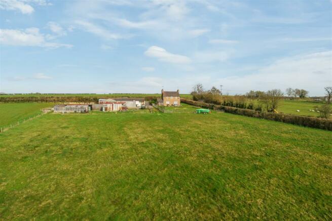
Sunnydene Farm is located to the west of the village of West Camel and to the south of the A303. It is set in open countryside and is the only property along a no through road. It is located just 0.6-kilometres (0.4-miles) from the A303, which is ideal for those commuting to work.
The site that is being offered for sale is shown outlined in red on the site plan, which is shown overleaf. It is shown for identification purposes only and the plan is not to be relied upon.
The field (to the south of the site) extends, in total, to approximately 0.46-hectares (1.13-acres). It is available by separate negotiation at a guide price of £40,000. The field is shown outlined in blue on the site plan.
DETAILED PLANNING PERMISSION
SSDC, dated 1st December 2022, granted detailed planning permission (application number: 20/01206/FUL) for the demolition of the existing farmhouse and outbuildings and the erection of 7no. dwellings (all open market), together with associated infrastructure works. The permission is subject to 24no. conditions.
SECTION 106 AGREEMENT
We understand the threshold for Section 106 Agreement contributions has not been met by the detailed planning permission; therefore, there will not be any contributions.
COMMUNITY INFRASTRUCTURE LEVY
We understand that Community Infrastructure Levy (CIL) will be payable at a rate of £40-per sq. m. (£4.45-per sq. ft.) subject to indexation (BCIS All-in Tender Price Index). The net additional floor space, as set out in the CIL Form 1: CIL Additional Information is 703.3-sq. m. (7,570.2-sq. ft.).
PROPOSED RESIDENTIAL DEVELOPMENT SCHEME
The proposed residential development scheme (PRDS) comprises 7no. dwellings, together with associated infrastructure works.
The scheme has a mix of semi-detached and detached, 2, 3 and 4-bed, 2-storey dwellings. Plots 1, 2 and 5 have double garages and the remaining plots have car parking spaces.
Plots 1-6 will be accessed from Keep Street with a new junction. Plot 7 will be accessed from Keep Street with a separate access.
PHOSPHATE MITIGATION STRATEGY
The PRDS has an approved phosphate mitigation strategy in the form of replacing the existing septic tank with a package treatment plant. The buyer will be responsible for the implementation of the solution.
OVERAGE
The seller’s preference is for an overage provision to be contained within the sale contract. The details of the overage provision are subject to further discussion.
VALUE ADDED TAX
The seller has not (and shall not) opt to tax; therefore, Value Added Tax (VAT) will not be payable in addition to the purchase price.
All interested parties should make their own enquiries with HMRC.
FIXTURES AND FITTINGS
All fixtures and fittings are to be excluded from the sale of the site.
RIGHTS OF WAY, WAYLEAVES AND EASEMENTS
The sale is subject to all rights of support, public and private rights of way, water, light, drainage and other easements, quasi-easements, all or any other like rights, whether mentioned in these particulars or not.
Please note that there is a public right of way across the field.
Situation - The village of West Camel is within the administrative area of Somerset Council (SC) (formerly South Somerset District Council (SSDC)). Taunton, the county town of Somerset, is approximately 47.6-kilometres (29.6-miles) to the west (via the A303 and A358).
The village has a range of facilities and amenities including All Saints parish church, the Walnut Tree hotel, bar, and restaurant, a playing field with children’s play area and a multipurpose sports court and the Davis Hall, which hosts a wide variety of community events and societies. There is a network of footpaths around the village including the Leland Trail, which passes through the
village.
Yeovil being the regional centre for the area situated close to the Somerset/Dorset border provides a comprehensive range of excellent shopping, business and cultural facilities along with a desirable collection of restaurants, public houses and cafés. Yeovil is a very sporty town with a number of golf courses in the area, rugby union played at club level and Yeovil Town Football Club otherwise known as the Glovers.
Ham Hill to the west of Yeovil is centred on a huge Iron Age hill fort and is popular for picnicking, walking and mountain biking in the grassy hollows of the old quarry workings.
There are extensive opportunities for equestrian sport and active sailing clubs are based at Sutton Bingham Reservoir and in the Chew Valley.
Yeovil has some excellent road and rail links across the south and to London, making this a very desirable countryside location. There are two mainline railway stations at Yeovil Junction and Pen Mill with frequent daily trains to Exeter, Bristol and London Waterloo. The town is also served by four international airports – Bristol, Exeter and Bournemouth all within approximately an hour’s drive.
Services - All mains services are available near or on the site, with the exception of gas. The farmhouse is currently on a septic tank.
All interested parties should make their own enquiries with the Statutory Utility Providers.
Directions - what3words:
stew.corporate.buzzards
Brochures
Bridgehampton, Yeovil, SomersetBridgehampton, Yeovil, Somerset

NEAREST STATIONS
Distances are straight line measurements from the centre of the postcode- Yeovil Pen Mill Station5.1 miles

About Symonds & Sampson, Yeovil
2 Court Ash, Yeovil, BA20 1HG


Established in 1858, Symonds & Sampson's reputation is built on trust and integrity. Our aim is to provide individuals and businesses alike with high quality agency and professional services across residential, commercial and rural property sectors. Over 150 forward-thinking experts in our 16 regional offices will help you make the best decisions, ensuring that the buying, selling and managing of your most valuable asset is straight-forward and rewarding.
Notes
Disclaimer - Property reference 33356603. The information displayed about this property comprises a property advertisement. Rightmove.co.uk makes no warranty as to the accuracy or completeness of the advertisement or any linked or associated information, and Rightmove has no control over the content. This property advertisement does not constitute property particulars. The information is provided and maintained by Symonds & Sampson, Yeovil. Please contact the selling agent or developer directly to obtain any information which may be available under the terms of The Energy Performance of Buildings (Certificates and Inspections) (England and Wales) Regulations 2007 or the Home Report if in relation to a residential property in Scotland.
Map data ©OpenStreetMap contributors.