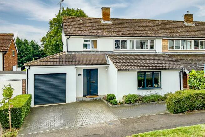
Barnfield Road, St. Albans, Hertfordshire, AL4

- PROPERTY TYPE
Semi-Detached
- BEDROOMS
4
- BATHROOMS
2
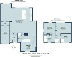
- SIZE
1,574 sq ft
146 sq m
- TENUREDescribes how you own a property. There are different types of tenure - freehold, leasehold, and commonhold.Read more about tenure in our glossary page.
Freehold
Key features
- Over 1500 Sqft
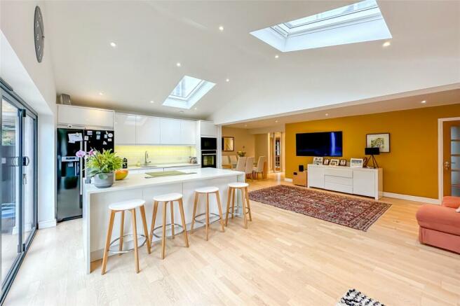
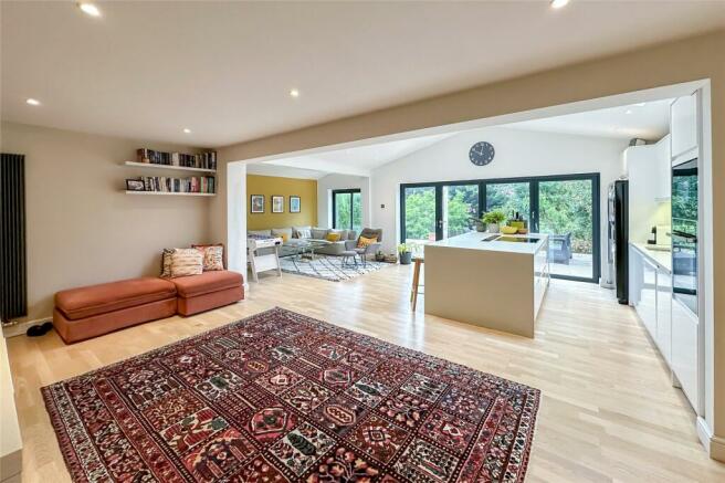
- Stunning Open Plan Living Space
- Vaulted Ceilings
- Bi-Fold Doors Onto Garden
- Contemporary Kitchen
- Luxury Bathroom
- South Facing Garden
- Walk To Outstanding Schooling
Description
The property is ideally placed within walking distance of outstanding schooling to include Skyswood Infant and Junior School and Sandringham Secondary School. The property has been extended to provide a wonderful open plan living space with bi-fold doors opening onto a south facing rear garden.
The property benefits from a useful cloakroom/utility area and a versatile family room which could potentially be used as an occasional fourth bedroom as there is also a ground floor shower room.
On the first floor there are three bedrooms and a stylish family bathroom. The property is located in a popular residential position with The Quadrant shopping parade close by as is Jersey Lane Tennis Club.
The open green spaces and woodland beyond Jersey Farm are a short cycle away, making this an ideal family home.
Brochures
Particulars- COUNCIL TAXA payment made to your local authority in order to pay for local services like schools, libraries, and refuse collection. The amount you pay depends on the value of the property.Read more about council Tax in our glossary page.
- Band: E
- PARKINGDetails of how and where vehicles can be parked, and any associated costs.Read more about parking in our glossary page.
- Ask agent
- GARDENA property has access to an outdoor space, which could be private or shared.
- Yes
- ACCESSIBILITYHow a property has been adapted to meet the needs of vulnerable or disabled individuals.Read more about accessibility in our glossary page.
- Ask agent
Barnfield Road, St. Albans, Hertfordshire, AL4

NEAREST STATIONS
Distances are straight line measurements from the centre of the postcode- St. Albans Station1.6 miles
- St. Albans Abbey Station2.2 miles
- Park Street Station3.1 miles
Notes
Staying secure when looking for property
Ensure you're up to date with our latest advice on how to avoid fraud or scams when looking for property online.
Visit our security centre to find out moreDisclaimer - Property reference HAR240156. The information displayed about this property comprises a property advertisement. Rightmove.co.uk makes no warranty as to the accuracy or completeness of the advertisement or any linked or associated information, and Rightmove has no control over the content. This property advertisement does not constitute property particulars. The information is provided and maintained by Bradford & Howley, Marshalswick. Please contact the selling agent or developer directly to obtain any information which may be available under the terms of The Energy Performance of Buildings (Certificates and Inspections) (England and Wales) Regulations 2007 or the Home Report if in relation to a residential property in Scotland.
*This is the average speed from the provider with the fastest broadband package available at this postcode. The average speed displayed is based on the download speeds of at least 50% of customers at peak time (8pm to 10pm). Fibre/cable services at the postcode are subject to availability and may differ between properties within a postcode. Speeds can be affected by a range of technical and environmental factors. The speed at the property may be lower than that listed above. You can check the estimated speed and confirm availability to a property prior to purchasing on the broadband provider's website. Providers may increase charges. The information is provided and maintained by Decision Technologies Limited. **This is indicative only and based on a 2-person household with multiple devices and simultaneous usage. Broadband performance is affected by multiple factors including number of occupants and devices, simultaneous usage, router range etc. For more information speak to your broadband provider.
Map data ©OpenStreetMap contributors.