
Soake Road, Waterlooville, Hampshire, PO7

- PROPERTY TYPE
Equestrian Facility
- SIZE
260,489 sq ft
24,200 sq m
- TENUREDescribes how you own a property. There are different types of tenure - freehold, leasehold, and commonhold.Read more about tenure in our glossary page.
Freehold
Key features
- SEE AND PRINT PDF SALES PARTICULARS AVAILABLE BELOW
- SEE DRONE VIDEO FOOTAGE ON THE VIRTUAL TOUR TAB
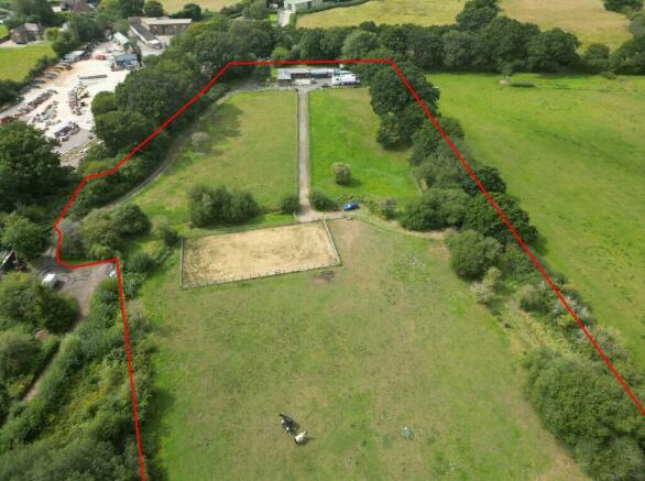
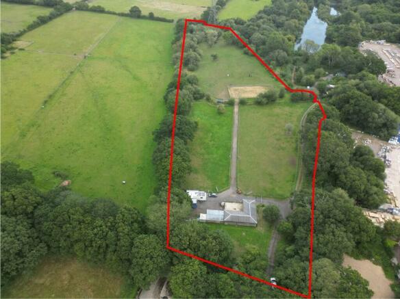
- EQUESTRIAN HOLDING
- APPROX. 5.98 ACRES IN ALL
- TIMBER STABLE BLOCK CONSISTING OF 4 STABLES, TACK ROOM AND TOILET
- OUTDOOR ARENA WITH SAND SURFACE
- 4.98 ACRES OF PASTURE
- WELL-POSITIONED BETWEEN DENMEAD AND WATERLOOVILLE
- SERVICES CONNECTED
Description
HEALTH AND SAFETY: Visiting parties enter the Property at their own risk.
VIDEO DRONE FOOTAGE: See the website and further details, photographs and drone video footage is available showing the whole Property.
LOCATION AND DIRECTIONS: See Location Plan 1 and 2. Postcode: PO7 6JA. The Property is located off Soake Road, Denmead. What3words of Vehicular Access:
DESCRIPTION: The Property comprises a timber stable block (See Floorplan below) containing 3 x stables (12ft by 12ft); 1 x stable (10ft by 12ft); 1 x tack room (12ft by 12ft) and a toilet (5ft by 12ft). There is also an equestrian yard (498m2/5364ft2), an outdoor arena (approx. 18m x 34m) with a sand surface, access tracks, pasture land and woodland pasture (approx. 4.98 acres/2.02 Ha) extending in all to approximately 5.98 acres (2.42 ha).
The Property has road frontage along and shared access directly from Soake Road on the western boundary via a hard track. It is well-screened from the surrounding properties and the road by established native hedgerows and trees. There is a significant ditch immediately inside the northern boundary of the Property. To the east of the Property are fishing lakes with associated carpark and buildings while to the south screened by hedging and trees is Jewson's Building Merchants.
There is potential for the property to be further developed for agriculture, equestrian or other alternative uses subject to planning where necessary.
The Property comprises part of Land Registry Title HP653741. Copy of Land Registry Title Plan and Register on the Selling Agent's website.
THE LAND: The pasture land extends to approximately 4.98 acres (2.02 Ha). There are a few trees scattered in the western part of the pasture land, however an area of land along the eastern boundary has a high enough density of trees to be considered woodland pasture. The land is relatively level and lies approx. 41m above sea level. The Agricultural Land Classification Map indicates Grade 4 and the subsoils on the Geological Survey Map indicate slowly permeable seasonally wet slightly acid but base-rich loamy and clayey soils.
PLANNING: The Property falls within the Winchester City Council Planning Authority and is identified as a Settlement Gap under Local Plan Policy NE7. It is located outside Settlement Boundaries and therefore Countryside Policies apply.
The only recent planning application affecting the Property relates to the timber stable building on site which was consented on 12th March 2018 under application reference 18/00104/FUL. This consent from the Winchester Local Planning Authority allowed the erection of the stable block to include 4 stables and tack room for private recreational use. Copies of Planning Documents and Decision Notice are available via link and on the Selling Agents Website.
SERVICES: The Property is connected to mains water, mains electricity and private drainage via a septic tank.
PRIVATE RIGHT OF WAY-FISHING CLUB: By Transfer dated 24th March 1994, there is a vehicular right of way over the Property being marketed for the use, enjoyment and maintenance of the fishing lake to the south. This right currently benefits the Portsmouth and District Angling Society who own the lake. The right of way is 15ft wide and consists roughly of the area hatched yellow on the Site Plan. The owner of the Property being marketed has the right to vary the route of the right of way at their own cost if required. Copy of Transfer Deed and Plan available on Selling Agent's Website.
OTHER RIGHTS: Within the same Transfer referred to above there is a right for the owners of the fishing lake to the south to access the Property in order to maintain a ditch/watercourse the location of which is evident on the Site Plan below. There is also a right to use this ditch/watercourse for draining water from the Property to the south.
PUBLIC RIGHTS OF WAY: No public rights of way affect the Property.
ENVIRONMENTAL DESIGNATIONS: No significant environmental or planning designations affecting the Property have been identified. The Property is situated outside the South Downs National Park.
BUSINESS RATES: Not currently demanded or assessed.
EASEMENTS: A National Grid pylon is situated on the eastern boundary of the Property. There is likely to be a wayleave agreement affecting the Property allowing maintenance of this pylon, the overhead electricity cables and associated infrastructure.
RIGHT OF CONNECTION: The Vendor intends during the sale to reserve the right to connect to the pylon line in the future.
ADDITIONAL LAND AVAILABLE:
An area of woodland/scrub extending to approximately 0.76 acres adjacent to the Property is available with the Property. This area is shaded orange on the Site Plan.
An additional 54 acres of agricultural land is available adjacent to the Property to the east. See to Selling Agent's Website.
LOCAL AUTHORITY: Winchester City Council, City Offices, Colebrook Street, Winchester SO23 9LJ.
Brochures
Sales Particulars- COUNCIL TAXA payment made to your local authority in order to pay for local services like schools, libraries, and refuse collection. The amount you pay depends on the value of the property.Read more about council Tax in our glossary page.
- Ask agent
- PARKINGDetails of how and where vehicles can be parked, and any associated costs.Read more about parking in our glossary page.
- Yes
- GARDENA property has access to an outdoor space, which could be private or shared.
- Yes
- ACCESSIBILITYHow a property has been adapted to meet the needs of vulnerable or disabled individuals.Read more about accessibility in our glossary page.
- Ask agent
Energy performance certificate - ask agent
Soake Road, Waterlooville, Hampshire, PO7

NEAREST STATIONS
Distances are straight line measurements from the centre of the postcode- Bedhampton Station3.8 miles
- Cosham Station3.9 miles
- Rowlands Castle Station4.1 miles
About Giles Wheeler-Bennett, Southampton
West Court, Lower Basingwell Street, Bishop's Waltham, SO32 1AJNotes
Staying secure when looking for property
Ensure you're up to date with our latest advice on how to avoid fraud or scams when looking for property online.
Visit our security centre to find out moreDisclaimer - Property reference SoakeRoadStablesPasture. The information displayed about this property comprises a property advertisement. Rightmove.co.uk makes no warranty as to the accuracy or completeness of the advertisement or any linked or associated information, and Rightmove has no control over the content. This property advertisement does not constitute property particulars. The information is provided and maintained by Giles Wheeler-Bennett, Southampton. Please contact the selling agent or developer directly to obtain any information which may be available under the terms of The Energy Performance of Buildings (Certificates and Inspections) (England and Wales) Regulations 2007 or the Home Report if in relation to a residential property in Scotland.
*This is the average speed from the provider with the fastest broadband package available at this postcode. The average speed displayed is based on the download speeds of at least 50% of customers at peak time (8pm to 10pm). Fibre/cable services at the postcode are subject to availability and may differ between properties within a postcode. Speeds can be affected by a range of technical and environmental factors. The speed at the property may be lower than that listed above. You can check the estimated speed and confirm availability to a property prior to purchasing on the broadband provider's website. Providers may increase charges. The information is provided and maintained by Decision Technologies Limited. **This is indicative only and based on a 2-person household with multiple devices and simultaneous usage. Broadband performance is affected by multiple factors including number of occupants and devices, simultaneous usage, router range etc. For more information speak to your broadband provider.
Map data ©OpenStreetMap contributors.