Land off Anmore Lane, Waterlooville, Hampshire, PO7

- PROPERTY TYPE
Land
- SIZE
2,378,812 sq ft
220,999 sq m
Key features
- SEE AND PRINT PDF SALES PARTICULARS AVAILABLE BELOW
- SEE DRONE VIDEO FOOTAGE ON THE VIRTUAL TOUR TAB
- APPROX. 54.61 ACRES
- BARE AGRICULTURAL LAND
- IMMEDIATELY ADJOINING RESIDENTIAL DEVELOPMENT
- AGRICULTURAL LAND CLASSIFICATION MAINLY GRADE 4 WITH SOME GRADE 3
- REASONABLY LEVEL
- OUTSIDE SOUTH DOWNS NATIONAL PARK
- POTENTIAL FOR FUTURE RESIDENTIAL DEVELOPMENT
- CURRENTLY IN GRASS
Description
Interested parties are recommended to park in the neighbouring residential Wecock Estate at the position shown on the Site Plan to the east of Position D with address: Partridge Gardens, PO8 9XS - What3Words
From there on foot head west to enter the land at Position D being the Public Bridleway. Parties can walk south from Position D to Position E. Parties can go over Gate 1 and walk the land and through Gate 2 heading north.
Parties are able to walk along the access and Public Bridleway from Position D to reach Anmore Lane at Position A. Parties can walk from Position D north-east towards the Balancing Pond and Pumping Station.
After an initial unaccompanied viewing Parties can then request an accompanied viewing with the Selling Agent.
VIDEO DRONE FOOTAGE: See Selling Agent's website for further details, photographs and drone video footage is available showing the whole Property.
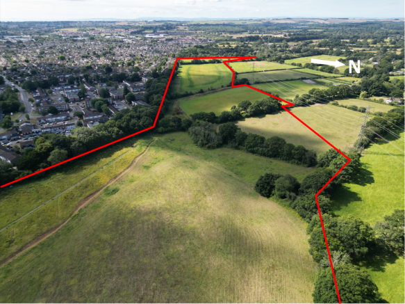
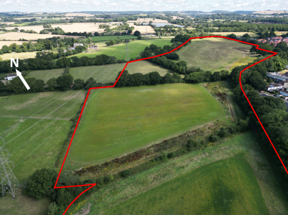
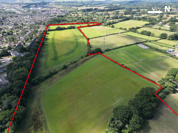
LOCATION: See Location Plan. On which the Property is shaded red.
DESCRIPTION: The block of land was historically part of a larger farm. Bare land with no services connected. Boundaries generally fenced. It adjoins residential development to the east.
The land has been in arable production in the past. The land is currently down to grass and is fenced and being grazed with cattle. There is access for agricultural vehicles either from Anmore Lane (via A, B and C) or from the east at Position F.
The Agricultural Land Classification records Grade 4 mainly with an area to the north east being Grade 3 and the Geological Survey Plan indicates the subsoils of the majority of the land being 'loamy and clayey' and being slowly permeable, with the north eastern area being 'loamy' and freely draining. The land is generally level, the northern area gently slopes. Height above sea level of approx. 50m.
LAND REGISTRY: The Property comprises the entirety of Land Registry Title HP860039 and part of Title HP653741. See Selling Agent's website for copies of Title Plans and Registers.
SHARED ACCESS OFF ANMORE LANE: See Site Plan. The Property benefits from vehicular access via a right of way off Anmore Lane shown yellow between A, B and C. The track connects to Position D. Note - there is a Public Bridleway over part of this route between positions B and C.
AGRICULTURAL ACCESS: The Property benefits from agricultural access at 2 locations:
At point F from the neighbouring residential development.
Across approx. 350m of neighbouring agricultural land to the south of the Bridleway/Access and to the west of Position C and to include access for Combine Harvesters to reach the land to the south of Position C.
PLANNING: The majority of the Property lies within the Local Authority areas of East Hants District Council and Winchester City Council and with the northern most area within East Hants District Council. See contact details within these Particulars.
DESIGNATIONS: The Property is within a Nitrate Vulnerable Zone (NVZ). There are no other environmental type designations that affect the Property.
DRAINAGE EASEMENT: From the Pumping Station at Position F there are rights of easements (3m) for existing pipes located underneath Position Y.
BALANCING POND: In the north eastern part of the land at Position Z there is a pond created with open ditch draining south west over the land. This was created to serve the neighbouring residential development to the east. See Lease dated 29th September 2017 available on the Selling Agent's website.
TENURE AND POSSESSION OF AGRICULTURAL LAND: The land is currently grazed by cattle under a licence by the neighbouring farmer. The terms of which allow the Vendor to provide 3 months written notice for the farmer to vacate.
ADDITIONAL LAND AND ACCESS: One of the Vendors also owns land and Stables which adjoins the Property off the south western edge at Position X on the Site Plan. This could provide additional potential access and connectivity to Soake Road/Anmore Lane. This property is also simultaneously being offered for sale. Approx. 5.98 acres with Price Guide £375,000. See Selling Agent's website for details.
LEASE: An area to the north east of the Property is currently under a Lease with the developer who constructed the Balancing Pond and Pumping Station. The purpose of this was to cover the land severed by the added open drainage ditch. This Lease can be terminated with by the Vendor following 3 months Notice.
AGRICULTURAL SUBSIDIES AND COUNTRYSIDE STEWARDSHIP: There are no schemes currently on the land.
DEVELOPMENT POTENTIAL: For at least the last 15 years residential developers and promoters have been pursuing the Vendor to enter Option or Promotional type agreements to allow the pursuit of Planning Consent for residential development. There are no current Agreements and the Vendors now wish to pursue a sale of the land.
DEVELOPMENT UPLIFT: Subject to the agreed Sale Price the Vendors are mindful to retain a 35% share of any uplift in value of the Property caused by Planning Consent for residential type development within the next 35 years.
SHELAA 2023: The land was promoted to Winchester City Council. See SHELAA Report on Selling Agent's website.
RETAINED RIGHTS: The Property retains various rights:
To connect into existing foul sewers at the Pumping Station and sewers beneath Position Y (subject to capacity).
To connect to other Services in this location.
The right to lay services over the Retained Land and Access between A-C.
The right to reposition the Balancing Pond and connected open ditch, at their expense.
PUBLIC RIGHTS OF WAY: A Public Bridleway crosses the Property between B, C and D on the Site Plan. See Site Plan and extract of Definitive Map on Selling Agent's website.
PRIVATE RIGHTS OF WAY: No private rights of way cross the Property.
PUBLIC ACCESS: Immediately inside the eastern boundary, against the Wecock residential estate, members of the Public and neighbouring householders walk over a narrow width of the land between positions D and E on the Site Plan. It appears that some access is currently taken on land that is not currently fenced and grazed between positions D and Y.
SERVICES: None connected to the Property.
RETAINED LAND: One of the Vendors owns the adjoining land with dwelling to the west outlined green on the Site Plan.
ADDITIONAL LAND AND ACCESS: One of the Vendors also owns land and Stables which adjoins the Property off the south western edge at Position X on the Site Plan. This could provide additional potential access and connectivity to Soake Road/Anmore Lane. This property was simultaneously being offered for sale. Approx. 5.98 acres with Price Guide £375,000. See Selling Agent's website for details. An offer has now been accepted and that sale is going through the legal process.
LOCAL AUTHORITY (NORTH): East Hampshire District Council, (EHDC), Penns Place, Petersfield GU31 4EX. Tel: .
LOCAL AUTHORITY (SOUTH): Winchester City Council (WCC), City Offices, Colebrook Street, Winchester SO23 9LJ. Tel: .
ADDITIONAL DOCUMENTS - There are various Legal Documents available from the Selling Agent's website.
Brochures
Sales ParticularsLand off Anmore Lane, Waterlooville, Hampshire, PO7

NEAREST STATIONS
Distances are straight line measurements from the centre of the postcode- Rowlands Castle Station3.6 miles
- Bedhampton Station3.8 miles
- Cosham Station4.3 miles
About Giles Wheeler-Bennett, Southampton
West Court, Lower Basingwell Street, Bishop's Waltham, SO32 1AJ
Notes
Disclaimer - Property reference 50acresClarendon. The information displayed about this property comprises a property advertisement. Rightmove.co.uk makes no warranty as to the accuracy or completeness of the advertisement or any linked or associated information, and Rightmove has no control over the content. This property advertisement does not constitute property particulars. The information is provided and maintained by Giles Wheeler-Bennett, Southampton. Please contact the selling agent or developer directly to obtain any information which may be available under the terms of The Energy Performance of Buildings (Certificates and Inspections) (England and Wales) Regulations 2007 or the Home Report if in relation to a residential property in Scotland.
Map data ©OpenStreetMap contributors.