
The Moor, Coleorton, LE67

- PROPERTY TYPE
Detached
- BEDROOMS
6
- BATHROOMS
5
- SIZE
3,860 sq ft
359 sq m
- TENUREDescribes how you own a property. There are different types of tenure - freehold, leasehold, and commonhold.Read more about tenure in our glossary page.
Freehold

Key features
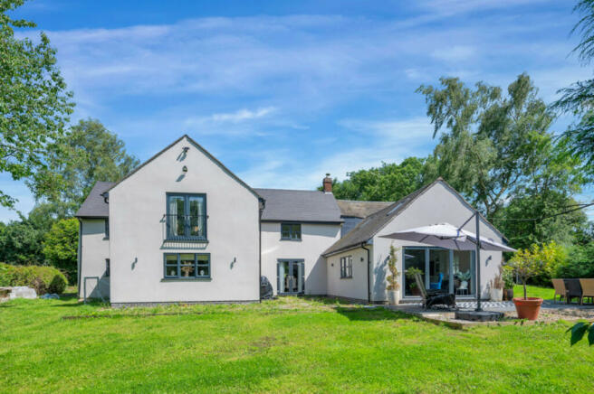
- Renovated & Extended Family Home with Separate, Two-Storey Barn
- Presented to a Show Home Standard
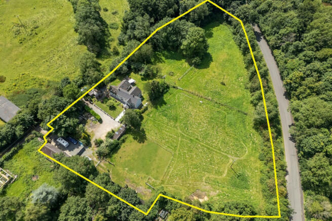
- 3.3 Acres in Total
- 4 Stables, Tack Room & Large Workshop
- Impressive Living Kitchen & 3 Reception rooms
- 4 Bedrooms & 4 Bathroom/Shower Rooms
- Separate Two-Storey Barn with 2 Bedrooms
- Planning Consent for a Four Car Garage
- West Facing Garden & Views Over Coleorton Valley
- Private Setting
Description
Location
Coleorton is an attractive village in Northwest Leicestershire close to the historic market town of Ashby-de-la-Zouch (3.5 miles) and Melbourne (5.2 miles). The Loughborough Road A512 dissects the village separating Lower Moor from upper Moor as it known. The Woodlands occupies an enviable position within upper Moor with views across the Coleorton valley. The village has a traditional pub/restaurant, primary school, church and village hall. Equidistant to Leicester, Derby and Nottingham the village is well served by major roads including the A42/M42, M1 and A50 East Midlands Airport and there are direct rail services to London St Pancras available at Loughborough, Leicester and East Midlands Parkway. Excellent private schools include the Manor House School in Ashby, Twycross House School, Dixie Grammar, Grace Dieu Manor, Loughborough High and Grammar Schools, Foremarke Hall and Repton.
Distances
Leicester 15.3 miles / Nottingham 23.4 miles / Derby 18.4 miles / Birmingham 31.9 miles / Loughborough 9.6 miles / Market Bosworth 10.4 miles / Tamworth 16.9 miles / East Midlands Airport 7.6 miles / East Midlands Parkway 14.9 miles / M1(J23a) 10.9 miles / A42(J13) 2 miles
Outside
The property stands in large grounds of 3.3 acres in total. Well hidden from the world outside, access to the property is via an unadopted track along which runs a public footpath. Two sets of electric gates open into the property which are each connected by a sweeping driveway. From the driveway a metal five-bar gate leads to a wooden stable block and two paddocks. Mature trees line the boundaries and wrapping around the property are landscaped gardens. Adjoining the living kitchen to the rear of the property are totally private, west facing gardens.
Detached Two-Storey Barn
Rebuilt to current regulations using reclaimed materials is this two-storey barn of cavity wall construction comprises of a large sitting room, breakfast kitchen and ground floor double bedroom with ensuite cloaks/WC. On the first floor is large bedroom with dressing room and ensuite bathroom with separate shower room.
Further Outbuildings
Four wooden stables and tack room, workshop and brick-built Home Office.
Planning Consent
There is currently planning consent for a four-car garage.
Services
The property has mains gas, water and electricity connected. Drainage is connected to a septic tank.
Local Authority
Northwest Leicestershire District Council.
Tenure
Freehold.
Directions
From junction 13 of the A42 take the A512 towards Loughborough. On entering Coleorton village turn right onto The Moor Road where the drive entrance can be found on the right-hand side just after No.40 The Moor.
- COUNCIL TAXA payment made to your local authority in order to pay for local services like schools, libraries, and refuse collection. The amount you pay depends on the value of the property.Read more about council Tax in our glossary page.
- Ask agent
- PARKINGDetails of how and where vehicles can be parked, and any associated costs.Read more about parking in our glossary page.
- Yes
- GARDENA property has access to an outdoor space, which could be private or shared.
- Yes
- ACCESSIBILITYHow a property has been adapted to meet the needs of vulnerable or disabled individuals.Read more about accessibility in our glossary page.
- Ask agent
The Moor, Coleorton, LE67

NEAREST STATIONS
Distances are straight line measurements from the centre of the postcode- Loughborough Station9.1 miles
Notes
Staying secure when looking for property
Ensure you're up to date with our latest advice on how to avoid fraud or scams when looking for property online.
Visit our security centre to find out moreDisclaimer - Property reference RX406012. The information displayed about this property comprises a property advertisement. Rightmove.co.uk makes no warranty as to the accuracy or completeness of the advertisement or any linked or associated information, and Rightmove has no control over the content. This property advertisement does not constitute property particulars. The information is provided and maintained by Fine & Country, Woodhouse Eaves. Please contact the selling agent or developer directly to obtain any information which may be available under the terms of The Energy Performance of Buildings (Certificates and Inspections) (England and Wales) Regulations 2007 or the Home Report if in relation to a residential property in Scotland.
*This is the average speed from the provider with the fastest broadband package available at this postcode. The average speed displayed is based on the download speeds of at least 50% of customers at peak time (8pm to 10pm). Fibre/cable services at the postcode are subject to availability and may differ between properties within a postcode. Speeds can be affected by a range of technical and environmental factors. The speed at the property may be lower than that listed above. You can check the estimated speed and confirm availability to a property prior to purchasing on the broadband provider's website. Providers may increase charges. The information is provided and maintained by Decision Technologies Limited. **This is indicative only and based on a 2-person household with multiple devices and simultaneous usage. Broadband performance is affected by multiple factors including number of occupants and devices, simultaneous usage, router range etc. For more information speak to your broadband provider.
Map data ©OpenStreetMap contributors.