Upper Kathlea Farm, Llangattock Lingoed, Abergavenny, NP7 8NR
- PROPERTY TYPE
Farm House
- BEDROOMS
5
- BATHROOMS
2
- SIZE
Ask agent
- TENUREDescribes how you own a property. There are different types of tenure - freehold, leasehold, and commonhold.Read more about tenure in our glossary page.
Freehold
Key features
- Superb views over open countryside.
- Livestock holding with an extensive range of modern buildings.
- Substantial Grade II Listed Farmhouse (subject to AOC).
- Further lots are available by separate negotiation.
- For sale as a whole or in five lots.
Description
The popular village of Llangattock Lingoed is less than ½ mile away and is located on the historic Offa's Dyke path. The village boasts a charming traditional Inn. The Hunters Moon offer Bed and Breakfast as well as a restaurant and traditional ales and is a popular destination for locals as well as walkers.
The larger town of Abergavenny (8 miles) and Monmouth (14 miles) are both within easy reach and offer an extensive range of high street retail shops, supermarkets and boutique shopping, with Abergavenny famed for its Food Festival held every September. Monmouth boasts an array of well established educational establishments and modern leisure and recreational facilities.
Both Abergavenny and Monmouth have excellent road links to Cardiff, Bristol and Birmingham with a railway station in Abergavenny providing rail travel to London and Manchester in less than 2 1/2 hours.
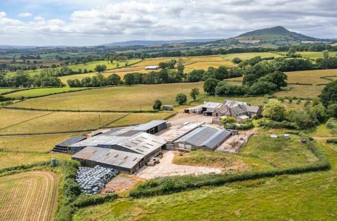
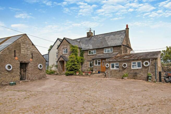
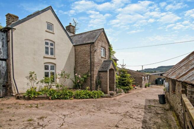
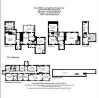
LOT 1: UPPER KATHLEA FARMHOUSE, FARMBUILDINGS AND 118.70 ACRES
Upper Kathlea Farm is approached over a private entrance drive leading off a quiet No Through Road. It occupies an elevated location commanding outstanding views over the surrounding countryside.
The farmhouse is believed to date back to the 17th Century and is Grade II listed. It is principally constructed of stone elevations under a slate roof and contains a wealth of period features including; exposed timber beams and feature fireplaces throughout, with a private garden to the rear and yards to the front.
The accommodation briefly comprises:-
Stone gabled porch with solid oak door leading into a vestibule and central hallway with two fine reception rooms. The sitting room has a woodburner on a stone hearth and exposed timber beams and across the hallway a large dining room with magnificent open fire place on a
decorative hearth.
The kitchen/diner is accessed from the sitting room together with its own tile floored porch from the outside. The kitchen benefits from a range of modern wall and floor units, oil fired Rayburn and a Rangemaster electric cooker with a gas hob. The kitchen flows into a spacious conservatory with further kitchen units ideal for dining and entertaining. Patio doors leads out onto the rear garden.
There is a useful utility room and store room to the front with access via the front porch. Above the kitchen is a spacious sitting room with a feature log burner on stone hearth and wonderful light from triple aspect windows.
From the main hallway there is a rear utility room with Belfast sink, plumbing for washing machine and the Worcester oil fired central heating boiler and door to rear. There is a separate shower room with electric shower and separate WC.
On the first floor there is four double bedrooms and a family bathroom with bath, wash hand basin and WC.
On the second floor is a large living space/bedroom with exposed beams and ensuite facilities.
The property is subject to an Agricultural Occupancy Condition (AOC). Further information can be found on Monmouthshire County Council Planning Portal under Planning Reference: M3817.
AGRICULTURAL BUILDINGS
The agricultural buildings are of modern and traditional construction and conveniently situated to the farmhouse. The traditional stone buildings offer scope for alternative uses (subject to Planning Consent).
The modern buildings comprise an extensive range of steel framed and timber structures which are principally used for livestock, fodder and machinery storage. The buildings have been maintained to a good standard and are ideal for livestock rearing.
THE LAND
Extending to approximately 118.70 acres, the land is contained within a ring fence surrounding the homestead. It comprises a mainly level area of permanent pasture which is divided into good size enclosures. There is ample shade and shelter for livestock. All fields have access to water
tanks supplied by the borehole/spring.
The soil is a medium loam which is ideal for livestock production. All of the land is classified as Grade 2 and 3 according to Agricultural Land Classification Predictive Map (Wales).
A FURTHER FOUR LOTS ARE AVAILABLE BY SEPARATE NEGOTIATION:-
LOT 2: THE PADDOCKS - Guide Price: £400,000
The Paddocks is situated off the entrance drive to Upper Kathlea Farm. It is believed to have been constructed in the late 1990's of brick elevations under a slate roof.
The spacious accommodation includes: Sun Room, Kitchen, Living Room, Dining Room, Office, Three Bedrooms (one ensuite), Family Bathroom, Utility Room and Shower Room.
The property sits in a plot of approximately 0.31 acres and includes a patio area, large garden and lawns together with gravelled parking area.
The property is subject to an Agricultural Occupancy Condition (AOC). Further information can be found on Monmouthshire County Council Planning Portal under Planning Reference: M3817.
LOT 3: RANGE OF MODERN BUILDINGS AND 30.29 ACRES - Guide Price: £350,000
Situated adjacent to Upper Kathlea Farm and has direct frontage to an unclassified Council Road.
The buildings comprise of two apex modern buildings approx. 20.34m x 22.86m (steel portal frame) and 27m x 22.86m (pole barn) with part concrete floors and doors to front and rear. To the rear is an area of hard standing.
LOT 4: 31.75 ACRES PASTURE LAND AT POOL HALL - Guide Price: £285,000
Situated off Pool Hall Road from Llanvetherine to Llangattock Lingoed. The land comprises two excellent mainly level areas of pasture with extensive roadside frontage. The soil is a versatile loam. The whole extends to approximately 31.75 acres.
LOT 5: 12.95 ACRES OF LAND AT CHURCH MEADOW - Guide Price: £90,000
Situated to the South of the village of Llangattock Lingoed. The land comprising of a single enclosure of gently undulating permanent pasture and extends to approximately 12.95 acres. There are a number of mature trees around the perimeter and a natural water course along
the southern boundary.
Please download our brochure for full details.
Joint selling Agent: RG & RB Williams
Brochures
Brochure- COUNCIL TAXA payment made to your local authority in order to pay for local services like schools, libraries, and refuse collection. The amount you pay depends on the value of the property.Read more about council Tax in our glossary page.
- Ask agent
- PARKINGDetails of how and where vehicles can be parked, and any associated costs.Read more about parking in our glossary page.
- Yes
- GARDENA property has access to an outdoor space, which could be private or shared.
- Yes
- ACCESSIBILITYHow a property has been adapted to meet the needs of vulnerable or disabled individuals.Read more about accessibility in our glossary page.
- Ask agent
Energy performance certificate - ask agent
Upper Kathlea Farm, Llangattock Lingoed, Abergavenny, NP7 8NR

Add an important place to see how long it'd take to get there from our property listings.
__mins driving to your place
About Williams Associates Chartered Surveyors, Penpergwm
The Old School The Bryn Penpergwm Abergavenny Monmouthshire NP7 9AHYour mortgage
Notes
Staying secure when looking for property
Ensure you're up to date with our latest advice on how to avoid fraud or scams when looking for property online.
Visit our security centre to find out moreDisclaimer - Property reference 0202. The information displayed about this property comprises a property advertisement. Rightmove.co.uk makes no warranty as to the accuracy or completeness of the advertisement or any linked or associated information, and Rightmove has no control over the content. This property advertisement does not constitute property particulars. The information is provided and maintained by Williams Associates Chartered Surveyors, Penpergwm. Please contact the selling agent or developer directly to obtain any information which may be available under the terms of The Energy Performance of Buildings (Certificates and Inspections) (England and Wales) Regulations 2007 or the Home Report if in relation to a residential property in Scotland.
*This is the average speed from the provider with the fastest broadband package available at this postcode. The average speed displayed is based on the download speeds of at least 50% of customers at peak time (8pm to 10pm). Fibre/cable services at the postcode are subject to availability and may differ between properties within a postcode. Speeds can be affected by a range of technical and environmental factors. The speed at the property may be lower than that listed above. You can check the estimated speed and confirm availability to a property prior to purchasing on the broadband provider's website. Providers may increase charges. The information is provided and maintained by Decision Technologies Limited. **This is indicative only and based on a 2-person household with multiple devices and simultaneous usage. Broadband performance is affected by multiple factors including number of occupants and devices, simultaneous usage, router range etc. For more information speak to your broadband provider.
Map data ©OpenStreetMap contributors.