
Molland Cross, South Molton

- PROPERTY TYPE
Land
- SIZE
1,342,519 sq ft
124,724 sq m
Key features
- Farm Land Used for Grazing
- 30.82 Acres (12.47 Hectares)
- Direct Road Access
- Small Area of Woodland
- Remains of a Former Farmstead
- For Sale by Private Treaty
- FREEHOLD
Description
Situation - The land lies in a rural but accessible location between South Molton and the Exmoor National Park with the nearest village of Brayford approximately 2.2 miles to the north-west. North Molton is about 3.5 miles to the south-east.
The market town of South Molton lies 5.5 miles to the south and the A399 can be accessed within 2.6 miles of the land. and provides a link to the A361 (North Devon Link Road) at the North Aller roundabout.
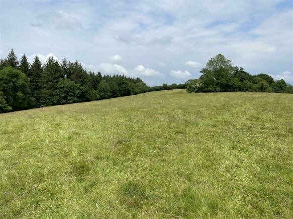
Description - The land comprises an appealing mixed block of pasture and woodland with the remains of a former farmstead known as Lower Molland. In total there are approximately 30.82 acres (12.47 hectares).
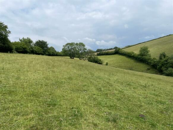
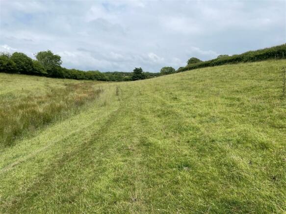
The grass land is gently sloping and sloping and currently used for grazing, although some of the fields would be suitable for mowing. The boundaries are mostly mature hedgerows and the soils are described as freely draining slightly acid loamy soils with the land being classified as grade 3.
The remains of the former farmstead known as Lower Molland include stone walls of two buildings which are now surrounded by some mature oak trees.
There is a stream flowing through the pasture fields closest to the road and on the south-western boundary there are some steeper fields and some deciduous woodland which totals approximately 3.2 acres.
Access - There is direct access to the land from the public highway.
Services - There are no mains services connected. We understand that there is a mains water pipe passing through the land. There is also a small stream which flows through the land.
Tenure - The land is owned freehold and is not registered on the Land Registry. The land is let on a grazing licence until the 31st December 2024. Vacant possession will be available after this date.
Method Of Sale - The land is offered for sale by private treaty, as one lot.
Designations - The land is within a Nitrate Vulnerable Zone (NVZ).
Land Management - The land is within a Sustainable Farming Incentive (SFI) agreement.
Local Authority - North Devon District Council. Tel: . (
Sporting And Mineral Rights - The sporting and mineral rights are not included with the freehold.
Wayleaves & Rights Of Way - The property is sold subject to and with the benefit of any wayleave agreement and any public or private rights of way that may affect it.
There are no public rights of way passing through the land,
The forestry commission have a right of way over part of the land for the purposes of extracting timber.
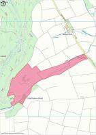
Land Plan - A plan which is not to scale, is included with these sale particulars for identification purposes only.
Viewing - Viewings are strictly by prior appointment with Stags. Please call or email: south- to arrange an appointment.
Directions - From the North Aller roundabout on the A361 to the north of South Molton. Proceed north on the A399 north and after 1.3miles turn right towards Simonsbath.
Follow this road for 2.1 miles and upon reaching the crossroads at Molland Cross turn left towards Brayford. Continue for 0.3 miles and the gate into the land will be found on the left.
What3words - Reference loved.play.outnumber
Disclaimer - Stags gives notice that: 1. These particulars are a general guide to the description of the property and are not to be relied upon for any purpose. 2. These particulars do not constitute part of an offer or contract. 3. We have not carried out a structural survey and the services, appliances and fittings have not been tested or assessed. Purchasers must satisfy themselves. 4. All photographs, measurements, floorplans and distances referred to are given as a guide only. 5. Whilst we have tried to describe the property as accurately as possible, if there is anything you have particular concerns over or sensitivities to, or would like further information about, please ask prior to arranging a viewing.
Brochures
Molland Cross, South MoltonMolland Cross, South Molton

NEAREST STATIONS
Distances are straight line measurements from the centre of the postcode- Umberleigh Station8.7 miles

About the agent
Stags, South Molton
29 The Square, South Molton, EX36 3AQ
Stags' South Molton office is easily found in the main Town Square. The A361 (North Devon Link Road) bypasses the town and provides excellent access to Barnstaple to the west and Tiverton and the M5 to the east.
Stags has been a dynamic influence on the West Country property market for over 130 years and is acknowledged as the leading firm of chartered surveyors and auctioneers in the West Country with 21 geographically placed offices across Cornwall, Devon, Somerset and Dorset. We take
Industry affiliations


Notes
Disclaimer - Property reference 33302539. The information displayed about this property comprises a property advertisement. Rightmove.co.uk makes no warranty as to the accuracy or completeness of the advertisement or any linked or associated information, and Rightmove has no control over the content. This property advertisement does not constitute property particulars. The information is provided and maintained by Stags, South Molton. Please contact the selling agent or developer directly to obtain any information which may be available under the terms of The Energy Performance of Buildings (Certificates and Inspections) (England and Wales) Regulations 2007 or the Home Report if in relation to a residential property in Scotland.
Map data ©OpenStreetMap contributors.