Mayhill Lane, Droxford, SO32

- PROPERTY TYPE
Detached
- BEDROOMS
3
- BATHROOMS
2
- SIZE
125,453 sq ft
11,655 sq m
- TENUREDescribes how you own a property. There are different types of tenure - freehold, leasehold, and commonhold.Read more about tenure in our glossary page.
Freehold


Key features
- SEE AND PRINT PDF SALES PARTICULARS AVAILABLE BELOW
- SEE DRONE VIDEO FOOTAGE ON THE VIRTUAL TOUR TAB
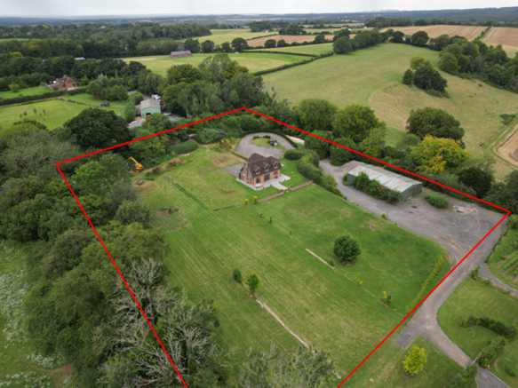
- APPROX. 2.88 ACRES IN ALL
- 3 BEDROOM HOUSE (1,850 SQ. FT.)
- AGRICULTURAL/FORESTRY OCCUPANCY CONDITION ON THE HOUSE
- PLANNING PERMISSION FOR GROUND FLOOR EXTENSION (1,033 SQ. FT.) 2 FURTHER BEDROOMS
- MODERN AGRICULTURAL BUILDING (2,545 SQ. FT.) AND YARD
- EXCEPTIONAL POSITION WITH FAR REACHING VIEWS ACROSS THE MEON VALLEY
- POSITIONED OFF A QUIET LANE
- WITHIN THE SOUTH DOWNS NATIONAL PARK
Description
VIDEO DRONE FOOTAGE: See the Selling Agent's website for further details, photographs and drone video footage is available showing the whole Property.
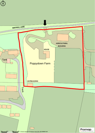
LOCATION: See Location Plan. What3Words:
DESCRIPTION: The Property extends in all to approx. 2.88 acres (1.16 Ha) as outlined red on the Site Plan.
The access back off Mayhill Lane rises to the elevated position of both the House and the Agricultural Building and Yard.
The Vendors purchased the Property as bare land in January 2008 and themselves achieved Planning Consent for the dwelling which is subject to an Agricultural/Forestry Occupancy Condition and which they constructed in 2015.
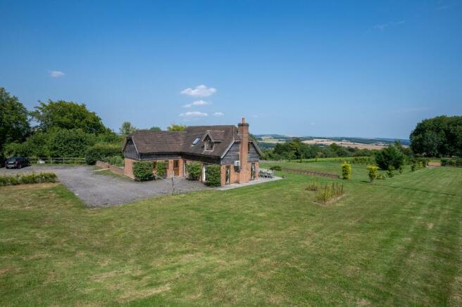
The house benefits from a spacious and modern layout with the existing accommodation extending to 1,850ft² (171.9m²). See Floor Plan.
Poppy Down Farm House occupies an exceptional elevated position offering far reaching views over the Meon Valley and towards Beacon Hill and Old Winchester Hill.
HOUSE AGRICULTURAL/FORESTRY OCCUPANCY CONDITION: Condition 6 of the Decision Notice of the Planning Consent for the house (dated 16th May 2012) states that:
'The occupation of the shall be limited to a person solely or mainly working, or last working, in the locality in agriculture or in forestry or a widow or widower of such a person, and to any resident dependants.'
The house Occupancy Condition can be satisfied by either agricultural or forestry related employment in the locality or by an appropriate enterprise being carried out at the Property. Alternatively, if a Purchaser was 'last working' in agriculture or forestry, or retired, then this would be suitable.
PLANNING CONSENT FOR HOUSE EXTENSION: The Vendors achieved Planning Consent for a ground floor extension November 2023 which will provide an additional 2 Bedrooms and 1,033ft² (96.0m²) of accommodation. This has not been constructed. If built by the Purchaser this would create a total of 2,883ft² (267.9m²) of accommodation within the house. See Plans and Elevations Click Here - and Planning History links on page 3.
COMMUNITY INFRASTRUCTURE LEVY (CIL): The Planning Consent ref SDNP/23/03389/HOUS is not liable to the CIL, therefore no payment is demanded or required.
AGRICULTURAL BUILDING: Currently used as a Store and Workshop, with office. Dimensions 20.0m x 12.0m with height to eaves 3.5m and ridge height of 4.7m. See Floor Plan. 5 Bay steel portal framed (part insulated cladding) with polished concrete floor. Water and electricity connected. Currently laid out with internal partitions. 2 x Roller Shutter Doors (width 3.0m x height 3.3m). Toilet connected. Hardstanding yard adjoining with access along either side of the building.
TIMBER AGRICULTURAL BUILDING: (5m x 10m) previously used for housing Turkey. The adjacent covered Aluminium Frame can remain on site if required.
PLANNING HISTORY: See below for planning reference numbers. Decision Notices are available on Selling Agent's website.
House - 16th May 2012 12/00216/SFUL
Agricultural Building - 18th March 2008 08/00443/APN
House Extension - 8th November 2023 SDNP/23/03389/HOUS
EQUESTRIAN ENTERPRISE: It is possible that the Occupancy Condition can be adjusted to include commercial equestrian enterprise but this would require a successful Planning Application. Interested parties must make their own enquiries to the Planning Authority or Planning Consultant if they are interested to investigate this opportunity.
LAND REGISTRY: The Property forms part of the Title HP480425. See Title Plan and Register on the Selling Agent's website. The Property as shown on the Site Plan includes a narrow width of land inside its western and southern boundary that is currently not shown on the current Title Plan.
SERVICES: Mains Electricity and Water. Heating via underfloor heating downstairs, and via radiators upstairs. Propane Gas Tank serving boiler. Treatment Plant serving house. Septic Tank serving Agricultural Building.
COUNCIL TAX: Property Band = E for year 2024/2025 = £2,617.04.
LOCAL AUTHORITY: Winchester City Council (WCC), City Offices, Colebrook Street, Winchester SO23 9LJ.
PLANNING AUTHORITY: South Downs National Park (SDNP), South Downs Centre, North Street, Midhurst, West Sussex GU29 9DH.
OFFER INSTRUCTIONS: Please see the Additional Document on our website for instructions as to how to make an offer by Private Treaty.
Brochures
Sales Particulars- COUNCIL TAXA payment made to your local authority in order to pay for local services like schools, libraries, and refuse collection. The amount you pay depends on the value of the property.Read more about council Tax in our glossary page.
- Ask agent
- PARKINGDetails of how and where vehicles can be parked, and any associated costs.Read more about parking in our glossary page.
- Secure,Driveway,Gated,Off street,Private
- GARDENA property has access to an outdoor space, which could be private or shared.
- Front garden,Private garden,Patio,Enclosed garden,Rear garden,Back garden
- ACCESSIBILITYHow a property has been adapted to meet the needs of vulnerable or disabled individuals.Read more about accessibility in our glossary page.
- Step-free access,Wet room,Level access shower,Level access
Mayhill Lane, Droxford, SO32

Add an important place to see how long it'd take to get there from our property listings.
__mins driving to your place
About Giles Wheeler-Bennett, Southampton
West Court, Lower Basingwell Street, Bishop's Waltham, SO32 1AJ
Your mortgage
Notes
Staying secure when looking for property
Ensure you're up to date with our latest advice on how to avoid fraud or scams when looking for property online.
Visit our security centre to find out moreDisclaimer - Property reference PoppyDownFarm. The information displayed about this property comprises a property advertisement. Rightmove.co.uk makes no warranty as to the accuracy or completeness of the advertisement or any linked or associated information, and Rightmove has no control over the content. This property advertisement does not constitute property particulars. The information is provided and maintained by Giles Wheeler-Bennett, Southampton. Please contact the selling agent or developer directly to obtain any information which may be available under the terms of The Energy Performance of Buildings (Certificates and Inspections) (England and Wales) Regulations 2007 or the Home Report if in relation to a residential property in Scotland.
*This is the average speed from the provider with the fastest broadband package available at this postcode. The average speed displayed is based on the download speeds of at least 50% of customers at peak time (8pm to 10pm). Fibre/cable services at the postcode are subject to availability and may differ between properties within a postcode. Speeds can be affected by a range of technical and environmental factors. The speed at the property may be lower than that listed above. You can check the estimated speed and confirm availability to a property prior to purchasing on the broadband provider's website. Providers may increase charges. The information is provided and maintained by Decision Technologies Limited. **This is indicative only and based on a 2-person household with multiple devices and simultaneous usage. Broadband performance is affected by multiple factors including number of occupants and devices, simultaneous usage, router range etc. For more information speak to your broadband provider.
Map data ©OpenStreetMap contributors.