
Holcombe Rogus, Wellington
- PROPERTY TYPE
Land
- SIZE
606,791 sq ft
56,373 sq m
Key features
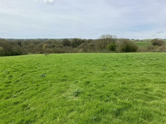
- Gently Sloping Pasture Land
- 13.93 Acres (5.64 Hectares)
- Access via a Hard Track
- Small Copse
- Currently Used for Grazing
- For Sale by Private Treaty
- FREEHOLD.
Description
Situation - The land at Whipcott Heights lies near to the Grand Western Canal, approximately 1.5 miles to the east of the popular village of Holcombe Rogus and within 1.8 miles of the A38 which links Wellington and Junction 27 of the M5.
The somerset town of Wellington is five miles away and the Mid Devon market town of Tiverton is eleven miles to the southwest. The Somerset County Town of Taunton and the vibrant and bustling city of Exeter are 12 miles and 22 miles away respectively.
Description - The land comprises a mixed area of gently sloping pasture land with a small copse and totals approximately 13.93 acres (5.64 hectares). The pasture land is divided into two enclosures and is currently used for grazing with a gentle north-west facing aspect.
The copse totals approximately 0.15 acres and lies within the lower pasture field.
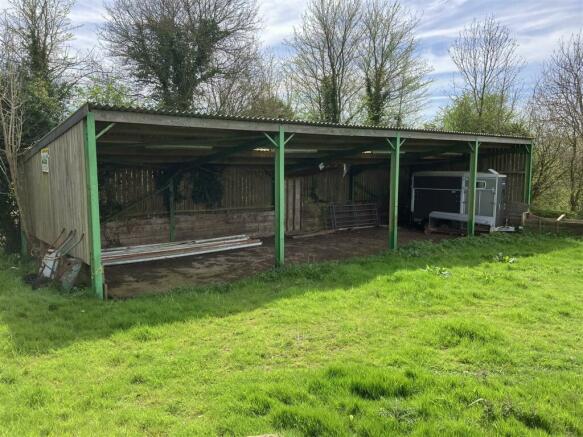
There is an OPEN FRONTED FARM BUILDING (60' x 20') which is constructed with a steel frame, low level concrete block walls with timber boarding above, a concrete floor and a corrugated metal roof.
Access - Access to the land is via the hard track which lies between the land and the public highway.
Services - There are no mains services currently connected to the land.
Method Of Sale - The land is offered for sale by private treaty, as one lot.
Tenure - The land is owned freehold and is registered on the Land Registry.
Designations - The land is within a Nitrate Vulnerable Zone (NVZ).
Material Information - The land was previously used as a waste landfill site (known as Higher Whipcott Quarry) and was operated by Viridor Waste Management Limited. The site is subject to ongoing monitoring.
Land Management - The land is not within any Countryside Stewardship (CS) or Sustainable Farming Incentive (SFI) schemes.
Local Authority - Mid Devon District Council. Tel: .
Sporting And Mineral Rights - The sporting and mineral rights insofar as they are owned are included with the freehold.
The mineral rights belong to a third party.
Wayleaves & Rights Of Way - The property is sold subject to and with the benefit of any wayleave agreement and any public or private rights of way that may affect it.
There are no public rights of way passing through the land.
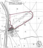
Land Plan - A plan which is not to scale, is included with these sale particulars for identification purposes only.
Viewing - Viewings are strictly by appointment with Stags. Please contact Stags or email: ) to arrange an appointment.
Directions - From J27 on the M5 motorway take the A38 to Wellington. After just under 5 miles turn left signposted Greenham and Holcombe Rogus. Just after ½ mile turn left signposted Holcombe Rogus and Westleigh. After 0.8 mile turn left signposted Burlescombe and Westleigh and ¼ mile along this road you will see the lane to Whipcott Heights on the right.
What3words - Reference visit.awakening.sweetened
Disclaimer - Stags gives notice that: 1. These particulars are a general guide to the description of the property and are not to be relied upon for any purpose. 2. These particulars do not constitute part of an offer or contract. 3. We have not carried out a structural survey and the services, appliances and fittings have not been tested or assessed. Purchasers must satisfy themselves. 4. All photographs, measurements, floorplans and distances referred to are given as a guide only. 5. It should not be assumed that the property has all necessary planning, building regulation or other consents. 6. Whilst we have tried to describe the property as accurately as possible, if there is anything you have particular concerns over or sensitivities to, or would like further information about, please ask prior to arranging a viewing.
Brochures
Holcombe Rogus, WellingtonHolcombe Rogus, Wellington

NEAREST STATIONS
Distances are straight line measurements from the centre of the postcode- Tiverton Parkway Station3.4 miles
About the agent
Stags, Wellington
7 High Street, Wellington, TA21 8QT
Stags wellington office is situated in the town centre with plenty of car parking close by. Stags has been a dynamic influence on the West Country property market for over 130 years and is acknowledged as the leading firm of chartered surveyors and auctioneers in the West Country with 21 geographically placed offices across Cornwall, Devon, Somerset and Dorset. We take great pride in the trust placed in our name and our reputation.
Stags offers the security of using an exceptional profe
Industry affiliations


Notes
Disclaimer - Property reference 33245754. The information displayed about this property comprises a property advertisement. Rightmove.co.uk makes no warranty as to the accuracy or completeness of the advertisement or any linked or associated information, and Rightmove has no control over the content. This property advertisement does not constitute property particulars. The information is provided and maintained by Stags, Wellington. Please contact the selling agent or developer directly to obtain any information which may be available under the terms of The Energy Performance of Buildings (Certificates and Inspections) (England and Wales) Regulations 2007 or the Home Report if in relation to a residential property in Scotland.
Map data ©OpenStreetMap contributors.