Land off Hensting Lane, SO50 7HH

- PROPERTY TYPE
Land
- SIZE
375,052 sq ft
34,843 sq m
Key features
- SEE AND PRINT PDF SALES PARTICULARS AVAILABLE BELOW
- SEE DRONE VIDEO FOOTAGE ON THE VIRTUAL TOUR TAB
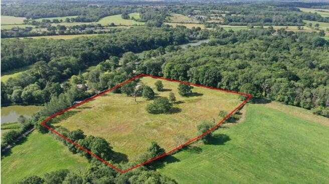
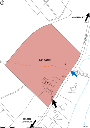
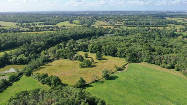
- APPROX. 8.61 ACRES (3.48 HA) IN ALL
- PLANNING CONSENT FOR REPLACEMENT AGRICULTURAL BUILDING (371.6 SQ. M./4,000 SQ. FT.)
- 2 X POLYTUNNELS (279 SQ. M./3,000 SQ. FT.)
- APPROX. 7.92 ACRES PASTURELAND WITH TREES
- MAINS WATER CONNECTED
- BOUNDED BY FENCING, WOODLAND AND MATURE HEDGEROWS
- LOCATED OFF COUNTRY LANE CLOSE TO FISHER'S POND
Description
VIDEO DRONE FOOTAGE: See Selling Agent's website for further details, photographs and drone video footage is available showing the whole Property.
LOCATION: See Location Plan 1 and Location Plan 2. The Property is located off Hensting Lane at the Colden Common end. It is approx. 2 miles to the south of Twyford and Morestead. What3Words:
DIRECTIONS: From Bishop's Waltham: Head west on the B2177 Winchester Road towards Fisher's Pond. Turn right at the traffic lights on to the B3354 towards Twyford and then take the first right into Hensting Lane. The Property is on the left hand side after approx. 150m.
DESCRIPTION: The Property extends in all to 8.61 acres (3.48 ha) as shown coloured on the Site Plan. It has been in use for hay production by the family for many years. It comprises a planning consent for a replacement agricultural building (371.6m2/4,000ft²); two Polytunnels (Polytunnel 1: 1625ft2/151m2; Polytunnel 2: 1375ft2/127.7m2) and approx. 7.92 acres of pastureland with some in-field trees. The site of the agricultural building and the Polytunnels are well-screened from the road by a small area of trees.
The Property consists of the majority of Land Registry Title no. HP566923 excluding a small area of woodland in the southern corner. See Selling Agent's Website for copies of Title Register and Plan.
See below schedule of Buildings for reference with the Site Plan.
A (Proposed) - 30.48m by 12.19m/100ft by 40ft - 371.6m2/4,000ft² - Planning consent for replacement agricultural building. Steel portal frame, corrugated fibre cement roof, timber cladding, and concrete floor (See Elevations and Floorplans).
B - 19.81m by 7.62m/65ft by 25ft - 151m²/1625ft² Steel framed Polytunnel structure.
C - 16.76m by 7.62m/55ft by 25ft - 127.7m²/1375ft² - Steel framed Polytunnel structure.
Total Areas - 650.3m²/7000ft².
ACCESS: Historically there were two accesses to the Property off Hensting Lane. One of these close to the proposed site for the agricultural building remains in use as marked by the black arrow on the Site Plan. As Hensting Lane is an unclassified, adopted tarmac road, it is possible that the second access marked by the blue arrow on the Site Plan could be reopened under agricultural permitted development rights. Interested parties are advised to make their own investigations on this aspect.
CONSENT FOR REPLACEMENT AGRICULTURAL BUILDING: Planning Consent was achieved on 13th December 2024 from Winchester City Council under application ref. 23/01907/APN to replace the agricultural building that was present on the Property until it was destroyed by fire on 30th July 2020. The footings, concrete pad and access track remain from the previous building. See Plans, Elevations and Decision Notice on the Selling Agent's website.
FENCING: The Property is bounded by established hedgerows and stock fencing. The Vendor is in the process of erecting post and wire fencing along part of the south-western boundary.
THE LAND: The pasture land extends to 7.92 acres (3.21 ha). The Agricultural Land Classification Map indicates Grade 3 and the Geological Survey Map indicates 'slowly permeable seasonally wet slightly acid but base-rich loamy and clayey soils'. The land gently slopes down to the south-east from around 50m above sea level to around 36m. The land currently in use for hay production would be suitable for various uses including agriculture, equestrian, recreation, Biodiversity Net Gain, conservation, and tourism subject to first obtaining planning consent where necessary.
SERVICES: Mains water is connected to both the proposed site for the agricultural building and to a trough in the pastureland as marked on the Site Plan. Mains electricity was previously connected to the proposed site for the agricultural building and is available. Mains drainage and gas are also available.
RIGHTS OF WAY: A public footpath crosses the Property as shown on the Site Plan. The relevant extract from the Hampshire Definitive Map of Public Rights of Way is provided on the Selling Agent's Website.
OTHER RIGHTS: By Deed of Grant dated 15th August 2012, Hampshire County Council were granted rights for the installation, use and future maintenance of culverting on a small area of land abutting Hensting Lane. See Selling Agent's Website for Copies of the Deed of Grant and Plan.
ENVIRONMENTAL/PLANNING DESIGNATIONS: No significant environmental or planning designations affect the Property. The adjoining Colden Common Wood (not being marketed) is classed as Ancient Woodland and a Site of Importance for Nature Conservation.
PLANNING: The Property falls within the Winchester City Council Authority and is identified as 'Countryside' on the adopted Winchester Local Plan.
LOCAL AUTHORITY: Winchester City Council, City Offices, Colebrook Street, Winchester SO23 9LJ. Tel: . Website:
DEVELOPMENT OVERAGE: The Vendors are mindful to retain a 30% share of any increase in value caused by planning consent for residential or commercial development within a 25 year period. If such development is achieved then a Purchaser will therefore benefit from the remaining 70%. This overage will not affect agricultural or equestrian uses or other types of use or planning consents that do not involve or are related to the construction of commercial buildings or housing.
LOCAL AUTHORITY: Winchester City Council, City Offices, Colebrook Street, Winchester SO23 9LJ.
Brochures
Sales ParticularsLand off Hensting Lane, SO50 7HH

NEAREST STATIONS
Distances are straight line measurements from the centre of the postcode- Shawford Station2.5 miles
- Eastleigh Station2.5 miles
- Chandlers Ford Station3.7 miles
About the agent
Giles Wheeler-Bennett, Southampton
West Court, Lower Basingwell Street, Bishop's Waltham, SO32 1AJ
Giles Wheeler-Bennett Chartered Surveyors & Land Agents is an established multi-disciplined land agency company practising throughout Hampshire and the surrounding counties and specializing in all aspects of rural property management.
We are an experienced team offering our clients a comprehensive, professional and friendly services and operate from an office in the historic market town of Bishop's Waltham.
Benefitting from an abundance of local knowledge and a reputable name, we
Notes
Disclaimer - Property reference FishersPondLandCommercial. The information displayed about this property comprises a property advertisement. Rightmove.co.uk makes no warranty as to the accuracy or completeness of the advertisement or any linked or associated information, and Rightmove has no control over the content. This property advertisement does not constitute property particulars. The information is provided and maintained by Giles Wheeler-Bennett, Southampton. Please contact the selling agent or developer directly to obtain any information which may be available under the terms of The Energy Performance of Buildings (Certificates and Inspections) (England and Wales) Regulations 2007 or the Home Report if in relation to a residential property in Scotland.
Map data ©OpenStreetMap contributors.