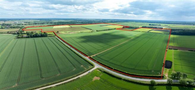
Land at Castlethorpe (352 Acres), Broughton, Brigg
- PROPERTY TYPE
Land
- SIZE
15,333,120 sq ft
1,424,495 sq m
Description
Location - The land is situated to the south of the village of Broughton and to the north of the M180 motorway in North Lincolnshire. The market town of Brigg lies about 2 miles to the south east. Junction 4 of the M180 is about 1 mile to the south west providing easy access onto the national motorway network.
Method Of Sale - The land is offered for sale by private treaty as a whole with the benefit of vacant possession upon completion. Offers for part may be considered.
Tenure & Possession - The freehold is part solely owned by Jerry Green Dog Rescue and part jointly owned by Margaret Green Animal Rescue and Jerry Green Dog Rescue, under Land Registry Title Numbers HS372763 and HS371436 respectively.
Mineral, timber and sporting rights are all included with the freehold in so far as they are owned, subject to any statutory exclusions.
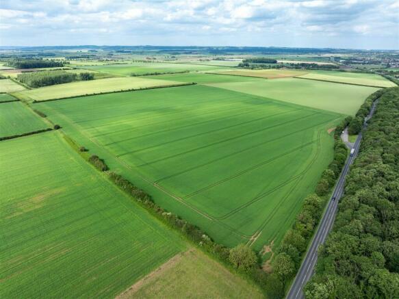
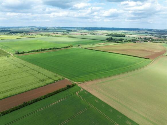
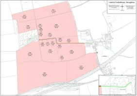
Land - The land is in an arable rotation and extends to approximately 142 hectares (352 acres) in 10 fields.
It is classified as being Grade 2 on Sheet 104 of the Provisional Agricultural Land Classification Maps as historically published by the Ministry of Agriculture, Fisheries and Food. The land is generally free draining. There are some land drains in places.
The soils are identified by the Soil Survey of England and Wales as being from the “Aberford” association which are described as “well drained calcareous fine loamy soils over limestone” and as suitable for “cereals, with some sugar beet and potatoes”.
All of the land lies within a Nitrate Vulnerable Zone and an area of the land is identified as being part of the Castlethorpe Tufas Site of Special Scientific Interest (SSSI). Further details on this are available upon request from the Joint Selling Agents.
Holdover/Early Entry - The land is currently let under an Agricultural Holdings Act 1986 tenancy which will end on completion of the sale whereupon vacant possession will be granted. Holdover will be granted to allow the current tenant to harvest the growing cereal crops and the sugar beet.
Early entry may be possible on exchange of contracts and the payment of a double deposit.
Countryside Stewardship Scheme - The farm is entered into an Entry Level/Higher Level Countryside Stewardship Agreement which has been extended. The current Agreement has a start date of 01/03/2012 and an end date of 29/02/2028. Details of the Agreement can be provided upon request from the Joint Selling Agents.
Wayleaves/Easements & Rights Of Way - The land is offered for sale subject to all existing rights, subject to and with the benefit of existing rights of way whether public or private, light, support, drainage, water and electricity supplies and other rights, easements and wayleaves whether referred to or not in these particulars.
Please note that there is a right of way off the B1208 through Castlethorpe Barns/White House Farm buildings as indicated on the attached sale and inset plans coloured green to access the land. This is also part of the route of a right of way in favour of the third party owners of Springfield Plantation which crosses the land along the route coloured brown and also uses the green route referred to above. There will be a right of way granted into the retained land immediately to the south of White House Farm, to provide access into the same, at point A, as shown on the plan and as also shown coloured brown.
Public footpath number 226 in the Parish of Broughton crosses part of the northernmost field comprised within this block of land.
There are three gas pipelines crossing parts of the land. These are a 15” spun iron medium pressure gas pipeline, PL1317 Killingholme to Scawby 30 and PL1322 Thornton Curtis to Butterwick high pressure gas pipelines.
There is a Ministry of Defence oil pipeline through the land.
Boundaries - The buyer(s) shall be deemed to have full knowledge of all boundaries and neither the Sellers, nor the Joint Selling Agents will be responsible for defining the boundaries or their ownership.
Outgoings - There is an annual General Drainage Charge payable to the Environment Agency.
Assumed Assessable Area 142 hectares
2024/2025 Charge £2.8271 per hectare or a total of £401.45
Services - There are no mains services connected. Buyers should make their own enquires as to services in the vicinity. There are no irrigation rights included with the sale.
Grant & Subsidy Schemes - The agricultural land has been included in claims for the Basic Payment Scheme. The delinked payments will be retained by the outgoing tenant and are not included in the freehold sale.
Overage - There will be a development clause/overage on the land for a period of 25 years from the date of completion.
The overage will be triggered for any development or renewable energy project. This will be implemented on the grant of planning permission or the disposal of land with the benefit of the permission, whichever is the sooner. The overage will be 30% in any uplift in value from the existing agricultural value.
Vat - It is understood that none of the land is elected for VAT.
Local Planning Authority - North Lincolnshire District Council, Church Square House, 30-40 High St, Scunthorpe DN15 6NL, Tel:
Buyer Identity Check - Prospective buyers will be required to provide the necessary identification for the purposes of the Anti-Money Laundering Regulations.
Plans & Areas - These have been prepared as carefully as possible. The plans and photographs are for illustrative purposes only and although they are believed to be correct their accuracy cannot be guaranteed. The photographs were taken in June 2024.
Viewing - The land can be viewed at any time during daylight hours but it is advised that interest is registered with the Joint Selling Agents to enable full access.
Joint Selling Agents - Perkins George Mawer & Co, Corn Exchange Chambers, Queen Street, Market
Rasen, Lincolnshire, LN8 3EH. T: E:
DDM Agriculture, Eastfield, Albert Street, Brigg, North Lincolnshire, DN20 8HS,
Tel: , E: andrew.
Brochures
Particulars of Sale - Land at Castlethorpe, BroughBrochureLand at Castlethorpe (352 Acres), Broughton, Brigg

NEAREST STATIONS
Distances are straight line measurements from the centre of the postcode- Brigg Station1.3 miles
- Barnetby Station4.5 miles
About the agent
Perkins, George Mawer & Co, Market Rasen
Corn Exchange Chambers, Queen Street, Market Rasen, LN8 3EH
Perkins, George Mawer & Co. are an independent firm of Chartered Valuation Surveyors, Estate Agents, Auctioneers and Valuers with a long standing commitment to our clients and the local economy.
We are able to offer a diverse range of professional services across the East Midlands and benefit from a dedicated team of experts with specialist skills ranging from residential agency, machinery sales, fine art and agricultural valuation.
With over 100 years of history in the Market Ras
Industry affiliations


Notes
Disclaimer - Property reference 33214640. The information displayed about this property comprises a property advertisement. Rightmove.co.uk makes no warranty as to the accuracy or completeness of the advertisement or any linked or associated information, and Rightmove has no control over the content. This property advertisement does not constitute property particulars. The information is provided and maintained by Perkins, George Mawer & Co, Market Rasen. Please contact the selling agent or developer directly to obtain any information which may be available under the terms of The Energy Performance of Buildings (Certificates and Inspections) (England and Wales) Regulations 2007 or the Home Report if in relation to a residential property in Scotland.
Map data ©OpenStreetMap contributors.