
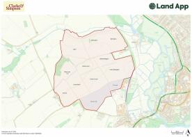
Land at Brundon, nr Sudbury
- PROPERTY TYPE
Land
- SIZE
14,744,189 sq ft
1,369,781 sq m
Description
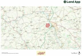
Location
The land lies in a pretty rural location just to the west of the west Suffolk town of Sudbury forming the border with Essex. The land lies approximately 16 miles north west of the city of Colchester and 19 miles south of Bury St Edmunds. The land is accessed directly from the public highway onto Finch Hill which connects into Sudbury Road and is 2.5 miles from the centre of Sudbury.
Method of Sale
We have been instructed to offer the property for sale by private treaty inviting offers for the whole with the intention of achieving exchange of contracts as soon as possible with completion four weeks thereafter or sooner by agreement.
It is expected that the purchaser/s will be required to sign an ‘Exclusivity Agreement’ with an ‘Exclusivity Fee’ being paid to and held by the Vendor’s solicitor. A copy of the draft ‘Exclusivity Agreement’ is available from the Agent.
Vendors’ Solicitor
Ellisons Solicitors, Stedman Chambers, 43 Head Street, Colchester, Essex CO1 1NH, attn Tim Logan, email tim. , tel. .
Local Authority
Babergh District Council, Endeavour House, 8 Russell Road, Ipswich, Suffolk IP1 2BX.
Description
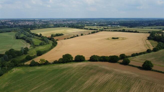
The land at Brundon Farm offers a purchaser an opportunity to acquire a productive block of arable land and woodland extending in all to approximately 338.48 acres (136.98 ha). The land is located in a desirable rural but convenient location in west Suffolk.
The arable land comprises approximately 317.90 acres (128.65 ha) in total. The land is gently undulating. It is classified as Grades 2 and 3 on the Land Classification series of England & Wales, being predominantly of the Ludford 571x and Melford 571o Soil Associations which are ‘deep well drained fine loamy, coarse loamy and sandy soils, locally flinty and in places over gravel. Slight risk of water erosion and some with calcareous clayey subsoils.’
There is good access from the public highway along a farm road which runs through the centre of the land.
The land has typically been in a white straw rotation of wheat, barley and sugar beet.
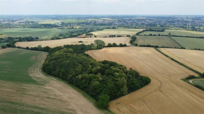
There is 9.2 acres (3.72 ha) of mature woodland which provides a purchaser with the opportunity to acquire a very attractive area of woodland for amenity, sporting or investment purposes.
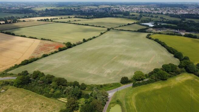
The permanent grassland lies on the northern boundary and comprises 9.41 acres (3.81 ha) and sits adjacent to the Belchamp Brook which leads into the River Stour.
The land is for sale in one lot and is shown for identification purposes only outlined red on the enclosed plan.
The arable land is contained in eight main parcels with a number of environmental strips. The land is drained and further details are available from the Agent. The land is cropped in winter wheat, winter barley and spring barley for the 2024 growing season.
The field boundaries are well defined with mature trees, hedgerows and ditches.
Viewings
At any reasonable time with particulars in hand by prior arrangement with the Agents. Given the potential hazards of a working farm and associated machinery, we please ask that you be as vigilant as possible for your own personal safety when making an inspection the property.
Rights of Way, Wayleaves and Easements
The property is sold subject to and with the benefit of all rights of way, wayleaves and easements that may affect the land.
There is a public footpath running along the full length of the farm track and a bridleway divides the arable land and permanent grass along the northern boundary. The farm track is shared as a secondary access for other properties owned by the Vendors and other residents of Brundon Farm (including Brundon Hall and Stone Cottage). The Vendors will retain a right of way for horse riding along the track. The purchaser will acquire the ownership of the track and rights of way will be provided to the third parties who will have a maintenance obligation for the track according to user, as shown marked A-B on the plan.
A right of way for agricultural purposes will be granted to the purchaser over the track coloured purple (an extension of Brundon Lane public highway). Maintenance will be according to user.
Timber, Sporting and Minerals
All sporting rights, standing timber and mineral rights (except reserved by Statute or to the Crown) are included in the sale of the freehold. The property offers good sporting potential.
Boundaries
These are shown for identification purposes only on the attached plan. Purchasers should satisfy themselves with regard to these as no error, omission or misstatements will allow the purchaser to rescind the contract nor entitle either party to compensation thereof.
The land is registered with the Land Registry under Title Number SK419251.
Town and Country Planning
The property is sold subject to any development plans, tree preservation orders, ancient monument orders and Town and Country schedules or other similar matters that may be or come into force.
Outgoings
The land is sold subject to any drainage rates and other outgoings that may be relevant.
VAT
Should any sale of the land, or any right attached to it, become a chargeable supplier for the purpose of VAT, such VAT shall be payable by the purchaser in addition to the contract price.
Tenure and Possession
The land is for sale freehold subject to a Farm Business Tenancy (FBT) until 11th October 2025. Early entry will be permitted after harvest 2025. There is an opportunity to convert the FBT to a Contract Farming Agreement upon completion, subject to agreement of terms. Use of a machinery store and grainstore may be provided to the purchaser on terms to be agreed. More details are available from the Agent.
Environmental Stewardship Scheme
The land is included within a Mid Tier Stewardship Scheme, agreement reference 1437698 which commenced on 01/01/2023. There are various areas of AB8 (flower rich margins) and AB9 (winter bird food). The scheme will be transferred to the purchaser upon completion. The Vendor will retain payment for the 2024 calendar year. Further details available in the Information Pack.
Overage
The Vendor will retain an overage condition on the land hatched in blue whereby the purchaser will pay to the Vendor any uplift in value for any planning permission obtained for non agricultural use for a period of 30 years at 30%.
Information Pack
An information pack containing further details relating to previous cropping, land drainage, woodland management plan, Countryside Stewardship is available for inspection at the Agent’s Office or can be emailed to interested parties.
NOTES
1. These particulars are produced in good faith, are set out as a general guide only and do not constitute any part of a contract. No responsibility can be accepted for any expenses incurred by intending purchasers or lessees in inspecting properties which have been sold, let or withdrawn. Interested parties should rely on their own/their surveyors investigations as to the construction type of the property and its condition. Any distances, and measurements which are given are approximate only. Any plans are indicative only and may not be the same as the transfer plan/s. No guarantee can be given that any planning permissions, building contents or building regulations have been applied for or approved.
2. Under Money Laundering, Terrorist Financing and Transfer of Funds (Information on the Payer) Regulations 2017 we, as Estate Agents, are required to obtain identification from buyers in the form of the photo page of your passport or a photo driving licence. The document must be in date. In addition, we need proof of address in the form of a utility bill with the name and address of the buyer. This must not be more than three months old. We are also under obligation to check where the purchase funds are coming from.
3. Potential purchasers should be aware that the land was previously designated as a possible route for the Sudbury Western Bypass which was cancelled by Suffolk County Council in November 2018 due to funding constraints.
Brochures
Brochure 1Land at Brundon, nr Sudbury

NEAREST STATIONS
Distances are straight line measurements from the centre of the postcode- Sudbury Station1.6 miles
- Bures Station5.6 miles
About the agent
Clarke and Simpson, Framlingham
Well Close Square, Framlingham, IP13 9DU
Clarke & Simpson is an independent firm of Chartered Surveyors dealing in rural property matters including estate agency, residential lettings, farm and land sales, professional valuations, estate management, auctioneering and architectural work. With a team of over thirty working from our office in the medieval town of Framlingham, we pride ourselves on our wealth of experience and knowledge and do our very best to a offer a completely dedicated, personal and
Industry affiliations


Notes
Disclaimer - Property reference S992376. The information displayed about this property comprises a property advertisement. Rightmove.co.uk makes no warranty as to the accuracy or completeness of the advertisement or any linked or associated information, and Rightmove has no control over the content. This property advertisement does not constitute property particulars. The information is provided and maintained by Clarke and Simpson, Framlingham. Please contact the selling agent or developer directly to obtain any information which may be available under the terms of The Energy Performance of Buildings (Certificates and Inspections) (England and Wales) Regulations 2007 or the Home Report if in relation to a residential property in Scotland.
Map data ©OpenStreetMap contributors.