Pershore, Bricklehampton

- PROPERTY TYPE
Farm Land
- SIZE
Ask agent
Description
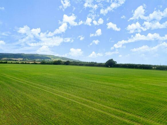
Access is provided via a double-gated hardcore track from the eastern boundary lane, with additional hardcore tracks within the lot. Historically, the land has been used for conventional arable farming, including potatoes. The fields are large, relatively flat, and bordered by drainage channels. The lot's boundaries are marked in red on the accompanying plan.
Introduction - Poplars Farm comprises an elegant double fronted Grade II Listed Georgian style five bedroomed farmhouse, with two bedroomed annexe set in around 319 acres of predominantly Grade II Arable Land in the Value of Evesham. The farmland is predominantly large level fields which have been farmed in a conventional arable rotation in recent years. The land has previously been used for vegetable production and there are irrigation rights from the River Avon to the north included in Lot 4. The farm can either be purchased as a whole or in 5 separate lots.
The farm can be easily accessed from the B4084, and is perfectly situated between Cheltenham and Worcester, both of which offer an extensive range of facilities. Nearby Pershore is a historic picturesque town renowned for its elegant Georgian architecture and magnificent Abbey. There is a direct train from Pershore to London Paddington in under two hours. Surrounded by beautiful countryside and charming villages, it is popular for ramblers and cyclists. Pershore boasts an excellent range of amenities, independent shops, a thriving social calendar with sports clubs and a theatre, a leisure centre, and numerous welcoming pubs and restaurants.
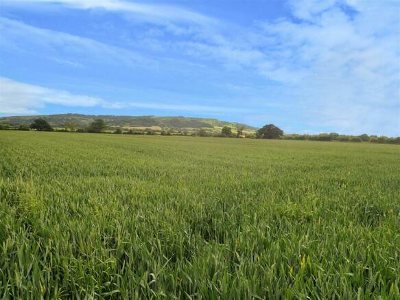
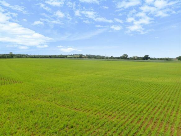
Lot 2: About 197.8 Acres Of Arable Land - The land extends to about 197.84 acres, of which 195.47 acres is arable land, 0.8 acres is Woodland and the remainder is yard, tracks and drainage ditches. The land is classified as Grade II quality, Soilscapes describes the land as slightly acidic, loamy and clayey soils with moderate to high fertility.
The main access to the land is via a double gated hardcore access track off the lane that forms the eastern boundary, as per the A marker on the plan. There is then a network of hardcore tracks providing access to the fields contained within this Lot.
The land has been farmed in a conventional arable rotation and was previously used for growing fresh produce including potatoes. The fields are predominantly large, relatively flat fields with drainage channels running around most of the boundaries. The extent of the lot is shown coloured red on the attached plan.
Access - Lot 1 will retain ownership of the access track with users required to make a fixed contribution to the upkeep. For further information please contact the selling agent.
Lot 2, 3, 4 and 5 benefit from gated roadside access as per the A markers on the attached plan. If sold separately no Lot has a right of access across another Lot.
Cottages - The two farm cottages, Poplars Lodge and Oak Tree Bungalow coloured blue and yellow respectively on the plan may be available by separate negotiation at an additional price. For further information please contact the selling agent.
Tenure - There is a Farm Business Tenancy over the land terminating 30th September 2024. The farmhouse annexe is currently let on an Assured Shorthold Tenancy.
Restrictive Covenant - The fields hatched black in Lot 2 will be sold subject to a restrictive covenant, preventing the erection of any structures including poly tunnels or solar panels.
Overage - Provision will be made for an Uplift Overage at 35% over a 35 year period from the date of acquisition, based on the increase in value above its agricultural value. Any Overage payments will be triggered by non agricultural / non equestrian or forestry use including as a result of Permitted Development Rights.
Wayleaves, Easements & Rights Of Way - The property is sold subject to and with the benefit of all easements, quasi easements, wayleaves, and rights of way both declared and undeclared. There is a known public right of way crossing Lot 2 from north to south and east to west.
Site Plans & Boundaries - The plans included in the sale particulars are for identification purposes only and may have been reduced in scale to assist with printing. Purchasers should satisfy themselves as to the extent of the Lot boundaries.
Basic Payment Scheme & Stewardship Schemes - The Vendors have claimed and will retain the BPS delinked payments. Insofar as we are aware the land is not the subject of any Environmental Scheme.
Minerals - The majority of the land in Lot 1, 2, 3 and 4 is included within the mineral safe guarding area for Terrace and Glacial Sand and Gravel in the Worcestershire Minerals Local Plan. Further information is available via Worcester Council website.
Sporting, Timber & Mineral Rights - All rights, if owned, are included in the sale.
Agents Note - Any plans used in the preparation of these details may have been reduced in scale and any interested parties should check the Title Plan before proceeding to purchase.
Important Notice - These particulars are set out as a guide only. They are intended to give a fair description of the property but may not be relied upon as a statement or representation of facts. These particulars are produced in good faith but are inevitably subjective and do not form part of any Contract. No persons within Sunderlands have any authority to make or give any representation.
Health & Safety Notice - Prospective Purchasers should take all necessary care when making an inspection including wearing suitable clothing. Viewings are taken solely at the risk of those who view and neither the Agents nor the owners of the property take responsibility for any injury however caused.
Directions - To locate the property, please enter the following postcode into your sat nav system: WR10 3JT.
The individual Lots are identified by the Sunderlands For Sale Boards.
What3words - Lot 2: ///jubilant.passes.shoulders
Brochures
Poplars Farm Sales Brochure.pdfBrochurePershore, Bricklehampton

NEAREST STATIONS
Distances are straight line measurements from the centre of the postcode- Pershore Station3.2 miles
- Evesham Station3.1 miles
- Worcester Parkway Station6.4 miles
About the agent
Sunderlands, Hereford
Offa House, St. Peters Square, Hereford, HR1 2PQ
Sunderlands are Herefordshire longest established independent estate agents who are proud to offer a professional quality service for both new and established clients. The combination of their local expertise and investment in the latest technology enables them to offer future vendors and buyers the very best service. If you are considering selling your property, be it, a city residence, rural cottage or even a large country home then start by contact one of our valuers and book a free market
Industry affiliations


Notes
Disclaimer - Property reference 33204483. The information displayed about this property comprises a property advertisement. Rightmove.co.uk makes no warranty as to the accuracy or completeness of the advertisement or any linked or associated information, and Rightmove has no control over the content. This property advertisement does not constitute property particulars. The information is provided and maintained by Sunderlands, Hereford. Please contact the selling agent or developer directly to obtain any information which may be available under the terms of The Energy Performance of Buildings (Certificates and Inspections) (England and Wales) Regulations 2007 or the Home Report if in relation to a residential property in Scotland.
Map data ©OpenStreetMap contributors.