Land South Of White Hill, Kinver, DY7 6AN
- SIZE
Ask agent
- SECTOR
Land for sale
Key features
- Freehold development opportunity in a prime residential location
- Comprehensive site area extending to 13.95 acres (5.65 hectares) gross
- Parcel benefitting from planning permission for up to 40 residential dwellings extends to 3.63 acres (1.47 hectares) gross
- Further opportunity for redevelopment of existing farmhouse and buildings and strategic promotion of land for an additional 80+ dwellings (STP)
- Offers invited for property - available in 3 lots
Description
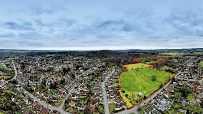
The property comprises a largely rectangular shaped parcel of greenfield land bounded on the northern boundary by White Hill. The eastern boundary adjoins residential dwellings, and the majority of the western and southern boundaries are bounded by established woodland. The comprehensive site area measures approximately 13.95 acres (5.65 hectares) gross, inclusive of the existing farm buildings.
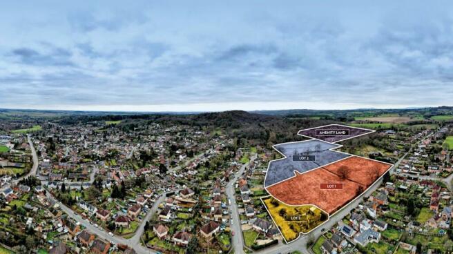
Phases to include the following: Lot 1 comprises greenfield land extending to circa 3.63 acres (1.47 hectares) gross fronting White Hill. Lot 1 benefits from Outline Planning Permission (App. 20/00621/OUT) for a residential scheme of up to 40 residential dwellings with associated infrastructure and open space.
Lot 2 extends to an area of 9.78 acres (3.96 ha) and benefits from a Safeguarded Land allocation for future residential development. This area of land has been removed from the Green Belt and is anticipated to be allocated for a minimum of 82 residential dwellings in accordance with the Local Plan Review Preferred Options (September 2021). A further area of amenity land may also be available (Lot 4).
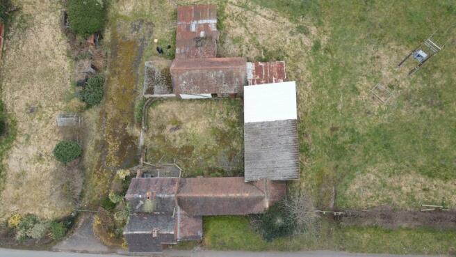
Lot 3 comprises a small farmhouse and former agricultural buildings which are currently vacant and in a derelict condition. The Phase extends to 0.54 acres (0.23 ha) and does not have any alternative planning permission. A RARE OPPORTUNITY TO ACQUIRE A PRIME RESIDENTIAL DEVELOPMENT OPPORTUNITY, COMPRISING VARIOUS LOTS, TO INCLUDE LAND WITH OUTLINE PLANNING PERMISSION AND FOR STRATEGIC PROMOTION.
Location
The property is located on the north western edge of the desirable South Staffordshire village of Kinver in an established residential area and benefits from an attractive semi-rural outlook whilst also being situated a short distance from local amenities on Kinver High Street.
Nearby mainline rail travel can be accessed at Stourbridge Junction (5.8 miles) Blakedown (5.8 miles) and Hagley (6.7 miles). Stourbridge Junction offers direct connections to Birmingham Moor Street (32 minutes' duration) and Worcester Shrub Hill (33 minutes' duration).
Junction 5 of the M5 Motorway is located approximately 12 miles distant via the Hagley Road and Junction 4 of the M5 Motorway is situated approximately 13.5 miles distant via the A491 and A449 providing connections into the wider surrounding motorway network.
Viewings
All parties wishing to inspect the property are required to make prior arrangements with Avison Young.
Avison Young request that interested parties do not attempt to gain access to the property outside of accompanied viewing inspections. We would request discretion in the event interested parties undertake any roadside inspections of the property.
Services and Planning
The property is within the jurisdiction of South Staffordshire Council and Lot 1 edged red on the plan benefits from an Outline Planning Permission under App no. 20/00621/OUT to develop a residential scheme of up to 40 residential dwellings, provision of public open space, sustainable drainage and other ancillary and enabling works, with all matters reserved excluding access. The S106 Agreement has been completed and is compliant with South Staffordshire Council policies on affordable housing (40% provision) and market housing mix. Financial commuted sums are due to be paid for items such as Public Open Space (and maintenance), Off Site Play Contribution and Off Site Ecology mitigation.
Lot 2 edged blue on the plan has been removed from the Green Belt and is safeguarded for future residential development. The draft Local Plan Review Preferred Options document illustrates a draft allocation for a minimum of 82 dwellings and is expected to be published shortly. Further land shown edged pink may be available on request for acquisition to support the promotion of the Lot 2 land. The Vendors have undertaken significant technical due diligence to support the planning application including a masterplan layout and promotion of the Lot 2 land. The information will be made available to interested purchasers for consideration on the dedicated technical data room.
Brochures
Land South Of White Hill, Kinver, DY7 6AN

NEAREST STATIONS
Distances are straight line measurements from the centre of the postcode- Stourbridge Town Station4.1 miles
- Blakedown Station4.3 miles
- Stourbridge Junction Station4.5 miles
About Avison Young (UK) Limited, Land & Development
65 Gresham Street, London, EC2V 7NQ
Notes
Disclaimer - Property reference 214806-1. The information displayed about this property comprises a property advertisement. Rightmove.co.uk makes no warranty as to the accuracy or completeness of the advertisement or any linked or associated information, and Rightmove has no control over the content. This property advertisement does not constitute property particulars. The information is provided and maintained by Avison Young (UK) Limited, Land & Development. Please contact the selling agent or developer directly to obtain any information which may be available under the terms of The Energy Performance of Buildings (Certificates and Inspections) (England and Wales) Regulations 2007 or the Home Report if in relation to a residential property in Scotland.
Map data ©OpenStreetMap contributors.