
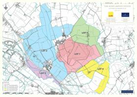
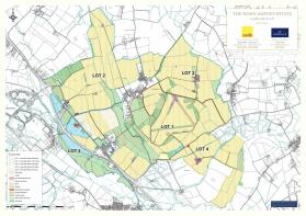
Lot 1 | Airfield Farm, Swindon, Gloucestershire, SN6

- PROPERTY TYPE
Land
- SIZE
39,143,887 sq ft
3,636,589 sq m
Key features
- Significant mineral deposits currently generating a substantial revenue stream and due to increase significantly in the short term (planning permission granted - gross income expected to (truncated)
- Substantial commercial arable farming enterprise
- Attractive and stable rental income stream generated from residential and commercial portfolio
- Future development opportunities
- 27 residential properties subject to a variety of tenancies plus a further 3 derelict
Description
Description
Airfield Farm
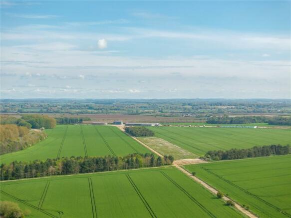
Airfield Farm is situated at the heart of the estate, with the farmland centred around the former RAF airfield, on which are extensive modern farm buildings servicing much of the estate. The majority of the farmland is in arable production, the balance being made up of grassland and woodland.
The concrete former airfield runways are used for a variety of
commercial uses, including general storage.
Minerals
Gloucestershire County Council recently resolved to grant planning permission for the development of Airfield Quarry
(reference 21/0032/CWMAJM) subject to planning conditions and a s106 agreement. This development covers 583 acres, with an extraction area of 440 acres. It’s predicted to yield 6.5 million tonnes of mineral over about 13 years, generating an annual indexlinked royalty income of approximately £1.8
million together with a surface rent of £190/ acre. Final restoration plans include a mix of arable, woodland, pasture, and meadow, ensuring sustainable land use post-extraction with opportunities for higher-value alternative uses. Hills Quarry Products Ltd are to operate this site.
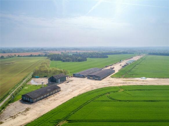
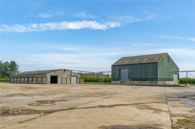
Airfield Farm Buildings
Airfield Farm has a range of modern farm buildings located towards the centre of the farm on the expansive concrete of the former RAF airfield. The buildings provide approximately 8,000 tonnes of grain storage with separate grain dryer building with intake pit serving all four stores via overhead conveyors. There is a weighbridge located in front of the grain dryer. The former runway is used for clamping of maize silage.
Farmland
Airfield Farm is a well accessed, ring fenced block of land classed as predominantly Grade 2 with an area of Grade 3 on the Provisional Land Classification Map. The farmed
area extends to 713.55 acres and is well serviced by a good range of internal farm roads and tracks. There are various parcels of woodland located across the Lot 1, extending to 127.33 acres in total.
Acreage: 898.62 Acres
Brochures
Web DetailsLot 1 | Airfield Farm, Swindon, Gloucestershire, SN6

NEAREST STATIONS
Distances are straight line measurements from the centre of the postcode- Swindon Station8.4 miles

About the agent
Savills, Residential & Country Agency
33 Margaret Street London W1G 0JD
Why Savills
Founded in the UK in 1855, Savills is one of the world's leading property agents. Our experience and expertise span the globe, with over 700 offices across the Americas, Europe, Asia Pacific, Africa, and the Middle East. Our scale gives us wide-ranging specialist and local knowledge, and we take pride in providing best-in-class advice as we help individuals, businesses and institutions make better property decisions.
Outstanding property
We have been advising on
Notes
Disclaimer - Property reference LAR240013. The information displayed about this property comprises a property advertisement. Rightmove.co.uk makes no warranty as to the accuracy or completeness of the advertisement or any linked or associated information, and Rightmove has no control over the content. This property advertisement does not constitute property particulars. The information is provided and maintained by Savills, Residential & Country Agency. Please contact the selling agent or developer directly to obtain any information which may be available under the terms of The Energy Performance of Buildings (Certificates and Inspections) (England and Wales) Regulations 2007 or the Home Report if in relation to a residential property in Scotland.
Map data ©OpenStreetMap contributors.