Woodcockdale Farm, Linlithgow, West Lothian, EH49
- PROPERTY TYPE
Land
- BEDROOMS
8
- BATHROOMS
5
- SIZE
28,122,336 sq ft
2,612,653 sq m

Key features
- Modern 8-bed farmhouse providing spacious family accommodation
- Useful and adaptable range of modern and traditional farm buildings
- Traditional buildings with development potential (subject to obtaining necessary planning consents)
- Productive areas of Grade 3 and 4 arable, silage and pasture ground
- Situated in a scenic and accessible location close to amenities
- Excellent mix of grazing land and amenity woodland providing sporting and amenity interests
- Land with potential to expand environmental and forestry interests through natural capital and afforestation schemes.
- About 261.27 Ha (645.60 Acres)
- For Sale as a Whole or in 6 Lots
Description
Woodcockdale Farm is an attractive and versatile mixed farming unit situated in a desirable part of West Lothian, a short distance to the south west of the popular town of Linlithgow and about 21 miles west of Edinburgh City Centre. The historic town of Linlithgow is well known for the impressive ruins of Linlithgow Palace, a former residence of the Scottish monarchy. There are a wide range of local amenities within Linlithgow including independent shops and places to eat and drink, Doctors Surgery, Pharmacies, Post Office, Sainsbury, Tesco, Aldi and M&S Food The town also has numerous sporting and recreational facilities including a leisure centre, golf course, rugby club, football club, tennis courts and cricket ground. Linlithgow also boosts several nurseries as well as highly regarded primary and secondary schooling, with a wide range of highly regarded independent private schools within Edinburgh or Glasgow.
There are excellent road links with both the M9 and M8 offering easy access to the whole of Central Scotland, Fife and beyond and Woodcockdale is within an hour’s drive of both Edinburgh and Glasgow. There is also the railway station at Linlithgow, which is on the main line, and offers regular services to Edinburgh, Glasgow, and Stirling making this an ideal base for commuting. Edinburgh Airport is within a 25 minute drive to the east and the larger towns of Bathgate, Falkirk, Livingston and Stirling are within easy reach by car and all provide an excellent and wider range of shops, professional services and transport links.
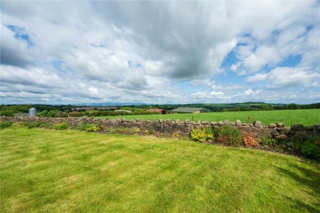
The farm benefits from an attractive outlook across the surrounding countryside to the north east and west. The area is home to an array of wildlife and provides great scope for the outdoor enthusiast with coastal walks at the nearby village of Blackness which has two beaches to the north and the network of paths through the Bathgate Hills to the south. There are many highly regarded golf courses in the area including Kingsfield, Linlithgow and West Lothian, with the championship courses at the Old Course at St Andrews, Gleneagles, Muirfield and Gullane in East Lothian which are just over an hour’s drive from the property.
This area of West Lothian is well served by a wide variety of agricultural contractors, merchants, and suppliers. Regular livestock sales are held at UA Stirling Agricultural Centre which is 20 miles to the north west, and Lanark 28 miles to the south west providing an excellent outlet for high quality livestock which the surrounding area is renowned for producing. Traditionally this area of West Lothian is known for its fertile land, capable of producing high yields of a versatile range of crops and livestock production.
FARMING SYSTEM
The Sellers have owned Woodcockdale Farm since 1961 and over the years have expanded the original farming holding through the acquisition of several neighbouring and additional outlying areas of land at Williamscraig, Easter Carribber, Castlehill and land at Manuel Mill. The farming system at Woodcockdale was historically centred on a mixed dairy and arable system with cereals and temporary grass grown as part of the rotation and with some of the grain and all of the straw used for home consumption. However, in 2008 there was change in farming policy and the dairy enterprise was replaced with predominately grassland based cropping system to accommodate the larger beef enterprise and the addition of a closed Lleyn cross sheep flock. The existing dairy buildings were converted for use by 180 suckler cows with followers taken through to finishing, and the farm also currently carries around 640 breeding ewes and 200 ewe hoggs plus followers. Although cow numbers have been reduced in recent years the existing farm steading has been substantially modernised and extended, with the land benefitting from regular applications of farmyard manure and slurry generated from the original dairy and more recently beef herd on the farm. The arable land can be worked to a good depth with a continuous programme of ditching and drainage works having ensured that all of the farmland is utilised to its maximum potential. The fields are well laid out and of a generous size, easily accommodating modern machinery, and are readily accessible directly either off the adjacent public roads or via an excellent network of internal tracks and farm roads.
DESCRIPTION
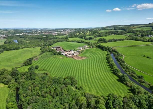
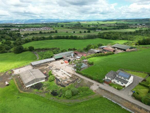
Woodcockdale Farm presents an excellent opportunity to acquire a mixed farming unit located in a highly accessible location within a sought after area of West Lothian. Woodcockdale Farmhouse, situated just to the south of the farm steading, provides spacious accommodation over two floors and is accessed via a shared farm drive which leads off the A706 public road. The farm benefits from an excellent range of modern and traditional farm buildings which are situated in a group and are surrounded by a productive block of farmland and amenity woodland which bounds the southern bank of the River Avon.
The farmland at Woodcockdale comprises an excellent mix of productive arable, silage and pasture ground along with several areas of grazing land and a mix of amenity woodland areas which are located throughout the holding providing shelter and amenity. The farmland extends to approximately 261.27 Ha (645.60 Acres) in total, with the majority of the arable and pasture ground largely classified by the James Hutton Institute as Grade 3.1 and 4.1/4.2 with some smaller areas of Grade 5 and 6 forming an excellent mix of grazing ground.
METHOD OF SALE
Woodcockdale Farm is offered for sale as a whole or in 6 lots. Please note Lots 2-6 will not be sold prior to the completion of Lot 1.
LOT 1: WOODCOCKDALE FARMHOUSE, FARM STEADING AND LAND EXTENDING TO ABOUT 26.60 HA (65.73 ACRES)
Woodcockdale Farmhouse
The farmhouse is situated just to the south of the farm steading and is accessed via a shared farm road which leads off the A706. The property was built in 1971 and is of block and brick cavity wall construction under a pitched tiled roof. The farmhouse benefits from panoramic views over the surrounding countryside and provides spacious family accommodation set out over two levels comprising an open-plan kitchen/living room, a large dining/sitting room, 8 bedrooms, 4 of which have ensuite bathrooms or showers. The accommodation and room dimensions are set out in more detail within the floor plans contained in the particulars.
Garden Ground
The farmhouse benefits from an attractive area of garden ground which surrounds the property and is mostly laid to lawn and enclosed by a stone dyke. There is a large area of concrete to the front and east of the house providing ample space for several vehicles. There is a timber garden store to the west of the house providing additional storage.
Woodcockdale Farm Buildings
The farm is serviced by an extensive range of traditional and modern farm buildings which are located immediately to the north and sitting just below the farmhouse. The majority of the buildings were previously used as part of the original dairy enterprise until 2008 but are now used in conjunction with the current beef and sheep enterprise on the holding. The buildings comprise:
1. Workshop (13.2m x 9.91m) of timber frame construction under a box profile roof with Yorkshire board side cladding and concrete floor. The bunded fuel station is available by separate negotiation.
2. Cattle Court 1 (24.1m x 19.2m) of steel portal frame construction under a corrugated roof with concrete panel walls, Yorkshire board side cladding and a concrete and stone floor.
3. Silage Pit with concrete side walls, earth back walls and concrete floor.
4. Cattle Court 2 (34.0m x 11.7m) of timber frame construction under a box profile roof with Yorkshire board side cladding and a concrete floor.
5. Lean-to Cattle Court 3 (45.5mx 11.89m) of steel portal frame construction under a box profile roof with concrete panel and brick walls and a concrete floor.
6. Cattle Handling Shed (35.9m x 11.2m) of steel portal frame construction under a box profile roof with stone and concrete panel walls and Yorkshire board and box profile side cladding and a concrete floor.
7. Former Farmhouse (10.7m x 4.63m) the remainder of the original farmhouse is of traditional stone construction under a slate roof with block and stone walls. The building is currently open along the front gable.
8. L-shaped Store Shed (3.97m x 3.6m) + (9.42m x 4.92m) of traditional stone construction under a corrugated roof with an earth floor.
9. Former Parlour Shed (12.7m x 4.6m) of steel portal frame construction under a box profile roof and side cladding with concrete floor.
10. Lean-to Store (12.76m x 2.92m) of brick construction under a corrugated roof with a concrete floor.
11. Former Cubicle Shed (29.9m x 10.3m) + (8.57m x 6.20m) of steel portal frame construction under a corrugated roof, tin side cladding, brick walls and a concrete and stone floor.
12. Former Cubicle Shed 2/Lean-to (18.2m x 8.89m) + (15.04m x 5.66m) of steel portal frame construction under a corrugated roof, tin side cladding, brick walls and a concrete and stone floor.
13. Straw Shed/Dutch Barn (21.62m x 18.82m) of steel portal frame construction under a corrugated tin roof with tin side cladding, brick and timber walls and a concrete, tarmac and stone floor.
14. Cattle Court 4 (22.8m x 11.9m) of steel portal frame construction under a corrugated roof, Yorkshire board side cladding, block walls and a concrete floor.
15. Implement Shed (18.8m x 5.43m) of timber frame construction under a mono pitched box profile roof with Yorkshire board side cladding and a concrete floor.
16. Modern Cattle Court 5 (36.69m x 31.02m) principal cattle shed with two lean-to cattle courts. Of steel portal frame construction under a box profile roof and side cladding with brick and block walls and stone floor. The lean-to sections are separated by motorway barriers and benefit from concrete floors.
17. Permastore located to the rear of the former cubicle shed there is redundant Permastore which was last used in 2008.
18. Collinson Feed Bin with capacity for up to 23 tonnes.
19. Portacabin
Yard Area
There is a large yard area of concrete and hard standing, linking the various buildings, with further area of land to the west of the buildings used as a dung midden.
Land at Woodcockdale Farm
The land in Lot 1 extends to about 26.60 Ha (65.73 Acres) in total and surrounds the farmhouse, farm buildings and is bound to the north and west by the River Avon, and to the south by the Union Canal and the A706. The land has been principally classified as Grade 3.1 by the James Hutton Institute. The majority of this land is down to a mix of arable and pasture ground with some small areas of amenity woodland located to the north of the farm steading and along the southern bank of the River Avon. The land is of varying aspect rising from 40m adjacent to the River Avon on the northern boundary to 78m above sea level at its highest point adjacent to the public road. The fields have benefitted from a healthy application of farmyard manure over the years and lie in a contiguous block with the majority of the field parcels being accessed directly from the farm steading or via field gates which lead from the A706.
LOT 2: LAND AT WILLIAMSCRAIG EXTENDING TO ABOUT 102.81 HA (254.04 ACRES)
The land within Lot 2 extends in total to approx. 102.81 Ha (254.04 Acres) and is located to the south east of Woodcockdale Farm and is bound to the north by Linlithgow Golf Course and surrounds several residential properties known as Williamscraig, Nethercraigs and Kettlestoun. The land comprises a productive mix of arable, pasture and grazing ground with some larger blocks of amenity woodland providing shelter and amenity to the holding. The land is generally of a northerly aspect and rising from 75m on the northern boundary adjacent to the Union Canal to 160m above sea level at its highest point on the northern boundary. The majority of the farmland to the north of the property has been classified by the James Hutton Institute as Grade 3.1 with the areas of grazing ground to the south being classified as Grades 4.2 and 5.1/5.2. The more productive enclosures are all laid out in a good size and well suited to use by modern machinery with the majority of the grazing fields benefitting from access to either a mains fed water trough or natural source water supplies. The land can be accessed directly from the A706 and benefits from a right of access over a private road between points A-B and C-D with the Sellers owning a half share of the road between B-C as outlined on the sale plan. Additionally, this lot benefits from a right of vehicular access only for agricultural purposes between points E-F and a pedestrian right only to herd livestock between points G-H.
LOT 3: LAND AND RUINS AT CARRIBBER GLEN EXTENDING TO 54.19 HA (133.90 ACRES)
The land in Lot 3 extends to about 54.19 Ha (133.90 Acres) in total and extends south west from Woodcockdale Farm and is bound to the north by the River Avon, with the majority of the field enclosures benefitting from direct access onto the A706 which bounds the land to the south. The land has been principally classified as Grade 3.1 with some smaller areas of land near the Carribber Glen classified as Grades 4.1 and 6.1 by the James Hutton Institute. The majority of this land is down to pasture with some larger blocks of amenity woodland located along the southern banks of the River Avon and including The Carribber Glen which has been designated by Scottish Natural Heritage as a Site of Special Scientific Interest (SSSI). The land is of a varying aspect rising from 60m adjacent to the River Avon on the northern boundary to 100m above sea level at its highest point within the Carribber Glen. Located on the edge of field 33 are the remains of Carribber Castle, “Robert Gib of Carribers” was the Queen’s principal baillie of the port of Newhaven in 1553. The fragmentary remains of his house stand on the right bank of the steep Carribber Glen. There are also the remains of two collapsed kiln structures on the northern boundary of field 31 and the remains of an historic stone structure within the south east corner of this field.
LOT 4: LAND AT EASTER CARRIBBER FARM EXTENDING TO ABOUT 34.81 HA (86.02 ACRES)
The land within Lot 4 extends to approx. 34.81 Ha (86.02 Acres) in total and is located south west of Woodcockdale Farm and comprises a mix of arable and grazing ground, with several small areas of land forming shelterbelt woodland. The land is generally of a northerly aspect and rising from 99m on the north east boundary adjacent to the public road to 161m above sea level at its highest point on the south eastern boundary of the land holding. The land benefits from shared access via a private road which forms part of the subjects of sale and leads from the A706 to Bowden Springs Fishery on the southern boundary, with a further right of access for agricultural purposes via a field gate which leads via a small section of private road onto the A706, between points P-Q on the sale plan. The farmland is all classified as Grade 3.1 and 4.2 by the James Hutton Institute and the majority of the ground is well suited to use for arable and fodder production with some small areas down to grazing ground.
LOT 5: LAND AT CASTLEHILL EXTENDING TO ABOUT 28.11 HA (69.46 ACRES)
The land within Lot 5 extends in total to approx. 28.11 Ha (69.46 Acres) and comprises a separate area of land which is located to the west of Woodcockdale Farm and to the north of Muiravonside Country Park which bounds the subjects to the south and east. The land comprises a productive and versatile block of arable land which has been classified as Grade 3.1 by the James Hutton Institute. The land is varying in aspect and rising overall from 83m at the lowest point adjacent to the Bowhouse Burn that flows east and splits the enclosures to 117m on the south west boundary of the land holding. The enclosures can be accessed directly from a field gate which leads onto the B803 or via two separate rights of access for agricultural purposes only over a neighbouring area of woodland and a tarmac road which leads to Muiravonside Country Park along the eastern boundary of the subjects shown as routes L-M and I-J-K on the sale plan respectively.
LOT 6: LAND AT MANUEL MILL EXTENDING TO ABOUT 14.75 HA (36.45 ACRES)
The land within Lot 6 extends in total to approx. 14.75 Ha (36.45 Acres) and is located to the west of Woodcockdale Farm and comprises a mix of productive and ploughable pasture and grazing ground. The land is varying in aspect and rising from the lowest point on the southern boundary at 63m to 94m above sea level. The farmland is all classified as Grade 3.1 by the James Hutton Institute and enclosed on 3 sides by neighbouring areas of amenity woodland. The land in Lot 6 benefits from an agricultural right of access over a private track which leads south east from the B825 between points N-O on the sale plan.
EPC Rating = E
Brochures
ParticularsEnergy Performance Certificates
EPC Rating GraphWoodcockdale Farm, Linlithgow, West Lothian, EH49

NEAREST STATIONS
Distances are straight line measurements from the centre of the postcode- Linlithgow Station2.1 miles
- Polmont Station3.0 miles
- Bathgate Station4.7 miles
About the agent
Galbraith, Stirling
Suite C1, Stirling Agricultural Centre, Stirling, FK9 4RN
Providing outstanding local knowledge, an international client base and 14 offices across Scotland and Northern England, Galbraith is uniquely placed to handle the sale, purchase and letting of residential property throughout Scotland & Northern England. Whether a castle or cottage, townhouse or rural property, sporting estate, farm, land or development, we specialise in top quality residential property.
Galbraith operates with over 200 staff in Aberdeen. Ayr, Blagdon, Castle D
Industry affiliations


Notes
Disclaimer - Property reference STR240040. The information displayed about this property comprises a property advertisement. Rightmove.co.uk makes no warranty as to the accuracy or completeness of the advertisement or any linked or associated information, and Rightmove has no control over the content. This property advertisement does not constitute property particulars. The information is provided and maintained by Galbraith, Stirling. Please contact the selling agent or developer directly to obtain any information which may be available under the terms of The Energy Performance of Buildings (Certificates and Inspections) (England and Wales) Regulations 2007 or the Home Report if in relation to a residential property in Scotland.
Map data ©OpenStreetMap contributors.