182.12 acres of Land At Bradfield St George, Bury St. Edmunds, Suffolk, IP30 0AY
Business rates & charges may apply

- SIZE
Ask agent
- SECTOR
Farm land for sale
Key features
- FOR SALE BY INFORMAL TENDER
- Grade 2 & 3 arable land and grassland
- As a Whole or in Six Lots
- OFFERS TO BE RECEIVED BY 9TH JULY 2024
Description
Grade 2 & 3 arable land and grassland
As a Whole or in Six Lots
OFFERS TO BE RECEIVED BY 9TH JULY 2024
Detailed Description
INTRODUCTION
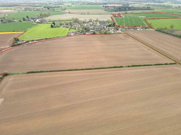
Broom Hall Farm extends to approximately 73.70 hectares (182.12 acres). The farm includes 69.36 hectares (171.41 acres) of arable land and 3.76 hectares (9.30 acres) of grassland.
The agricultural buildings adjacent to Lot 1, which are being retained by the Vendor, will be available to rent by separate negotiation.
LOCATION & SITUATION
The land lies in multiple blocks situated immediately around the village of Bradfield St George, which is approximately 9 miles from Bury
St Edmunds and 12 miles from Stowmarket in the county of Suffolk. The Beyton and Rougham A14 junctions are both 2.5 and 3.5 miles to the north with the A134 2.5 miles to the west.
LOT 1 - ARABLE LAND AND TRACK EXTENDING TO 25.01 HECTARES AS COLOURED RED ON THE SALE PLAN
The land comprises three arable fields extending to 24.55 hectares (60.76 acres). The land is accessed via a track, Hollybush Lane, which is also a restricted byway that leads off Freewood Street.
The Vendor will grant a right of access between points A-B as shown on the Sale Plan benefitting the land being sold. The southern and middle fields can be accessed off Hollybush Lane while the northern field can be accessed via a culvert crossing, situated adjacent to the wood, over the drain separating the northern field from the middle field.
LOT 2 - ARABLE LAND EXTENDING TO 20.20 HECTARES AS COLOURED GREEN ON THE SALE PLAN
The land comprises two arable fields extending to 20.20 hectares (49.92 acres) that benefit from road frontage and are situated between and opposite the existing dwellings forming Bradfield St George. Each field has various access points off Freewood Street, along with a culvert crossing linking the fields internally.
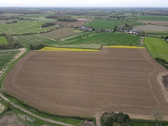
LOT 3 - ARABLE LAND EXTENDING TO 13.96 HECTARES AS COLOURED BLUE ON THE SALE PLAN
The land comprises two arable fields extending to 13.96 hectares (34.49 acres). The northern field is accessed via an access point off
Hollybush Corner, adjacent to 31 Hollybush Corner. While the southern field is accessible via a crossing over the drain separating the fields, we understand that the land also benefits from a right of access over the track serving Frog's Hall.
LOT 4 - ARABLE LAND EXTENDING TO 10.66 HECTARES AS COLOURED ORANGE ON THE SALE PLAN
The land comprises a single arable field extending to 10.66 hectares (26.33 acres) which can be accessed off Freewood Street.
LOT 5 - GRASSLAND EXTENDING TO 2.74 HECTARES AS COLOURED BROWN ON THE SALE PLAN
The land comprises a single grass field extending to 2.74 hectares (6.77 acres) which can be accessed off Freewood Street.
LOT 6 - (GRASS)LAND EXTENDING TO 1.02 HECTARES AS COLOURED YELLOW ON THE SALE PLAN
The land comprises a single field extending to 1.02 hectares (2.53 acres) which benefits from an access off Freewood Street. This parcel
is currently included within a Countryside Stewardship Scheme and has been partly sown with a Nectar Flower Mix for the duration of the scheme.
AGRICULTURAL BUILDINGS
The buildings and grain silos located adjacent to Lot 1 will be available to rent by separate negotiation. Further details for the buildings can be obtained from the Vendors Agent.
GENERAL REMARKS AND STIPULATIONS
SOIL CLASSIFICATION
The soils are mainly of the Ashley Soil Associations which is described by the Soil Survey of England and Wales as fine loamy over clayey soils with slowly permeable subsoils and slight seasonal waterlogging.
LAND CLASSIFICATION
The majority of the farm is shown as Grades 2 & 3 on the Provisional Ministry of Agricultural Classification Map for the Eastern Region.
METHOD OF SALE
The Property is for sale by Informal Tender on the following terms:
1. All offers must reach the office of Brown & Co, West Wing, Linden Square, 146 Kings Road, Bury St Edmunds, Suffolk, IP33 3DJ no later
than 10am Tuesday 9th July 2024. Email offers sent to nicholas. are preferred.
2. Offers should be submitted in the prescribed form. Copies of the form can be obtained from the Vendor's Agent.
3. Offers must be for a precise sum of pounds sterling. It is advised that offers should be for an odd figure to avoid the possibility of identical bids.
4. No offer will be considered which is calculated only by reference to another offer.
5. The Seller does not undertake to accept the highest or indeed any bid.
6. Full name and address of both Purchaser and their Solicitor should be provided with any offer.
7. All offers must evidence finance for the purchase and further particulars will be expected before an offer is accepted.
EXCHANGE OF CONTRACTS AND COMPLETION
Exchange of contracts to take place 21 days after receipt by the Purchaser's Solicitor of the draft contract with completion on the 30th
September 2024.
A deposit of 10% of the purchase price will be payable on exchange of contracts. If early entry is required, then purchasers will be asked to pay an additional 10% at that stage.
OVERAGE
The Vendor reserves the right to receive 35% of the uplift in value in the event that planning permission is granted on Lots 2, 4, 5 and 6 for any use other than agricultural or equestrian, running for a period of 25 years from the date of completion. Payment will be due on
implementation or on a sale with the benefit of planning permission, whichever is earlier.
HOLDOVER
A holdover provision will be required until 31st October 2024 for the cereal crops and until 31st January 2025 for the sugar beet to allow the Vendor to harvest any remaining crops relating to the 2024 harvest.
PAST CROPPING
A past Cropping Schedule is available from the Vendors Agent.
DE-LINKED PAYMENTS
The Vendor will receive and retain all future Basic Payment runoff or Delinking payments relating to the Land.
STATUTORY DESIGNATION
The land lies within a Nitrate Vulnerable Zone.
ENVIRONMENTAL SCHEMES
The property is currently entered into an Arable Offer under the Countryside Stewardship Scheme. The Scheme commenced on the 1st January 2021 for a period of five years. For further details are available from the Vendors Agent.
WAYLEAVES, EASEMENTS AND RIGHTS OF WAY
The farm is sold subject to and with the benefit of all existing rights, including rights of way, whether the public or private, light, support, drainage, water and electricity supplies and other rights, easements, and all wayleaves whether referred to or not in these particulars.
There are Public Rights of Way crossing Lots 1, 2, 3 and 5.
A Right of Access will be granted between points A-B benefitting Lot 1.
The southern land forming Lot 3 benefits from a Right of Way between points X-Y marked on the plan, subject to the owner of the lot 3 paying a fair proportion towards the cost of maintaining the track.
LAND DRAINAGE
The arable land does benefit from land drainage, and the Vendor has some plans which can be viewed by appointment.
OUTGOINGS
The Environmental Agency General Charge is payable in respect of the agricultural land.
VAT
Should any sale of the farm, or any right attached to it become a chargeable supply for the purpose of VAT, such tax shall be payable by the purchaser in addition to the contract price.
SPORTING, MINERALS AND TIMBER
All sporting and mineral rights and timber or timber like trees (except as reserved by Statute or to the Crown) are included in the sale.
TOWN AND COUNTRY PLANNING
The Purchaser will be deemed to have full knowledge and have satisfied themselves as to the planning matters that may affect the property.
FIXTURES & FITTINGS
All fixtures and fittings are excluded from the sale unless specifically referred to in these particulars.
PLANS, AREAS AND SCHEDULES
These have been prepared as carefully as possible and based on Ordnance Survey data. The plans are published for illustrative
purposes only and although they are believed to be correct, their accuracy is not guaranteed.
BOUNDARIES
The Buyer(s) shall be deemed to have full knowledge of all boundaries and neither the Seller nor the Selling Agents will be responsible for defining boundaries nor their ownership.
SELLING AGENT
Nicholas Staton
E: nicholas.
M:
Robert Fairey
E: robert.
M:
VIEWINGS
The land may be viewed at any time with a set of particulars to hand with interested parties first having registered their interest with the
selling agents (Brown & Co). People viewing the property should be careful and vigilant whilst on the property. Neither the Vendor or the
Vendor's Agents are responsible for the safety of those viewing the property and accordingly those viewing the property do so at their own risk.
USEFUL ADDRESSES
West Suffolk Council
West Suffolk House, Western Way, Bury St Edmunds, IP33 3YU
T:
Suffolk County Council
Endeavour House, 8 Russell Rd, Ipswich IP1 2BX
T:
ANTI MONEY LAUNDERING
In accordance with the most recent Anti Money Laundering Legislation, buyers will be required to provide proof of identity and
address to the selling agent once an offer has been submitted and accepted (subject to contract) prior to solicitors being instructed.
Brochures
182.12 acres of Land At Bradfield St George, Bury St. Edmunds, Suffolk, IP30 0AY

NEAREST STATIONS
Distances are straight line measurements from the centre of the postcode- Thurston Station3.1 miles
- Bury St. Edmunds Station5.1 miles
- Elmswell Station5.2 miles
About Brown & Co, Bury St Edmunds
West Wing Lindon Square 146 Kings Road Bury St Edmunds IP33 3DJ
Notes
Disclaimer - Property reference 442246FH. The information displayed about this property comprises a property advertisement. Rightmove.co.uk makes no warranty as to the accuracy or completeness of the advertisement or any linked or associated information, and Rightmove has no control over the content. This property advertisement does not constitute property particulars. The information is provided and maintained by Brown & Co, Bury St Edmunds. Please contact the selling agent or developer directly to obtain any information which may be available under the terms of The Energy Performance of Buildings (Certificates and Inspections) (England and Wales) Regulations 2007 or the Home Report if in relation to a residential property in Scotland.
Map data ©OpenStreetMap contributors.