North Barns Farm. (Lot 1), Bankfoot, Perth, PH1

- SIZE
Ask agent
- TENUREDescribes how you own a property. There are different types of tenure - freehold, leasehold, and commonhold.Read more about tenure in our glossary page.
Freehold
Key features
- About 43.3 ha (107.00 acres)
- Predominantly Grade 3(1)
- Areas of Grade 2
- Modern agricultural buildings
Description
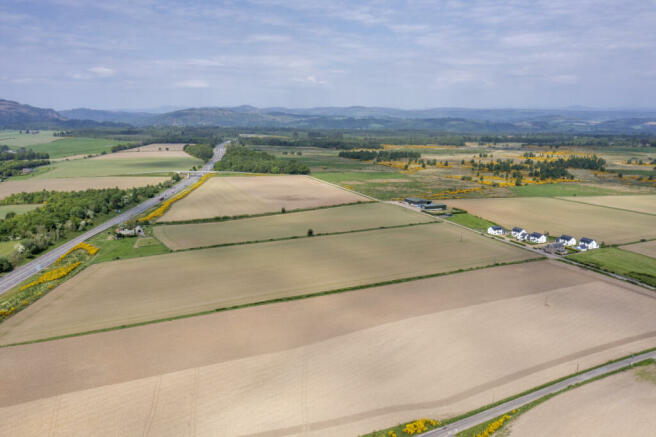
A productive farming unit in an easily accessible position just north of Perth, convenient for the A9. Predominantly Grade 3(1) with areas of Grade 2, with modern agricultural sheds.
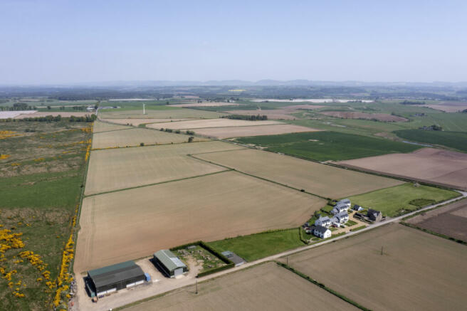
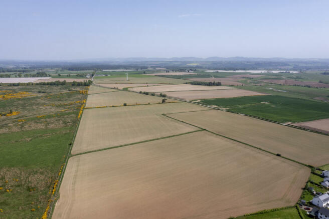
North Barns Farm extends to about 43.3 ha (107.00 acres) and include modern and sizeable agricultural sheds. The land is classified principally Class 3(1), with three fields Class 2 by the James Hutton Institute. It sits about 100 metres above sea level to 110 metres at its highest point.
The ground is predominantly level or gently sloping and is accessed by way of a farm track which is in the ownership of Transport Scotland following a Compulsory Purchase for the upgrading of the A9. The farm and the adjacent residential homes have a right of access over it.
The land has grown a variety of crops over recent years including spring barley, potatoes and peas as noted in the cropping schedule. Currently, there is an area around 4.5 ha (11.11 acres) set aside.
North Barns Farm has modern agricultural sheds to the east side of farm track, detailed below with Lot 1.
Lot 1 – North Barns Farm and modern agricultural sheds
The land at North Barns Farm lies to the east side of the A9 and is accessed from the minor road from Bankfoot to Murthly.
The land lies between the heights of 100m and 110 m above sea level. The area is shown on the Meteorological Office Average Rainfall Chart in the region of 850mm per annum.
The land is shown on the James Hutton Institute Land Capability for Agriculture Plans as being mainly of Class 3(1) with three fields, extending to 16.01 ha (39.56 acres) of Class 2.
The predominant soil type is a brown soil which is part of the Balrownie Association. The areas considered as Class 2, are made up of mineral podzols which are freely draining and part of the Forfar Association.
The indicative SEPA Flood Risk Maps show there is no risk of river or surface water flooding.
The boundaries are a mixture of post and wire fences as well as stone dykes. The farm has previously been utilised for arable cropping although, the boundaries are suitably stock proof.
The farm access is owned by Transport Scotland, with all rights of way in place. This is also shared with the housing development to the north of North Barns Farmhouse.
The farm access also forms part of the Coltrannie to South Barns core path. Path Code: AGVN/117.There are wayleaves in favour of Scottish Water and Scottish & Southern Energy.
The land to the east of the A9 carriageway lies within the Strathmore, Fife and Angus Nitrate Vulnerable Zone (NVZ). The land to the west is not within a Nitrate Vulnerable Zone (NVZ).
Services include mains water and to the farm buildings. Three phase electricity is available close by running along the march boundary wall.
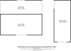
There are three sizable steel agricultural buildings:
Shed 1 – 30m x 15m with 6m height to the eaves, which was constructed in 2008
Shed 2 – 30m x 10m with max 6m height to the eaves, which was constructed in 2010
Shed 3 – 30m x 12m with 5m height to the eaves, which was constructed in 2014.
Services
The agricultural sheds have mains power and water.
Compulsory Purchase
A small amount of land was compulsory purchased for the upgrading of the A9, including the building of the new Coltrannie Bridge between North Barns Farm and Coltrannie Farm. Negotiations are well in hand for a small area of land running adjacent to the farm track to bought back into the farm title.
Brochures
Particulars- COUNCIL TAXA payment made to your local authority in order to pay for local services like schools, libraries, and refuse collection. The amount you pay depends on the value of the property.Read more about council Tax in our glossary page.
- Band: TBC
- PARKINGDetails of how and where vehicles can be parked, and any associated costs.Read more about parking in our glossary page.
- Ask agent
- GARDENA property has access to an outdoor space, which could be private or shared.
- Ask agent
- ACCESSIBILITYHow a property has been adapted to meet the needs of vulnerable or disabled individuals.Read more about accessibility in our glossary page.
- Ask agent
Energy performance certificate - ask agent
North Barns Farm. (Lot 1), Bankfoot, Perth, PH1

NEAREST STATIONS
Distances are straight line measurements from the centre of the postcode- Dunkeld & Birnam Station4.7 miles
About the agent
Bell Ingram, Perth
Durn, Isla Road, Perth, PH2 7HF
A Team You Can Trust
We understand that the decision to sell is never easy. The relationship between our agents and clients is based on trust and our team will give you the confidence that we will be able to achieve the best outcome for you. Drawing on over 100 years' experience, our professionals ensure your expectations are exceeded.
Industry affiliations


Notes
Staying secure when looking for property
Ensure you're up to date with our latest advice on how to avoid fraud or scams when looking for property online.
Visit our security centre to find out moreDisclaimer - Property reference PER240056. The information displayed about this property comprises a property advertisement. Rightmove.co.uk makes no warranty as to the accuracy or completeness of the advertisement or any linked or associated information, and Rightmove has no control over the content. This property advertisement does not constitute property particulars. The information is provided and maintained by Bell Ingram, Perth. Please contact the selling agent or developer directly to obtain any information which may be available under the terms of The Energy Performance of Buildings (Certificates and Inspections) (England and Wales) Regulations 2007 or the Home Report if in relation to a residential property in Scotland.
*This is the average speed from the provider with the fastest broadband package available at this postcode. The average speed displayed is based on the download speeds of at least 50% of customers at peak time (8pm to 10pm). Fibre/cable services at the postcode are subject to availability and may differ between properties within a postcode. Speeds can be affected by a range of technical and environmental factors. The speed at the property may be lower than that listed above. You can check the estimated speed and confirm availability to a property prior to purchasing on the broadband provider's website. Providers may increase charges. The information is provided and maintained by Decision Technologies Limited. **This is indicative only and based on a 2-person household with multiple devices and simultaneous usage. Broadband performance is affected by multiple factors including number of occupants and devices, simultaneous usage, router range etc. For more information speak to your broadband provider.
Map data ©OpenStreetMap contributors.