How Farm, Sanday, Orkney, Orkney Islands, KW17
- PROPERTY TYPE
Land
- SIZE
25,032,190 sq ft
2,325,569 sq m
Key features
- Modern 4 bedroom farmhouse
- Traditional 4 bedroom farmhouse
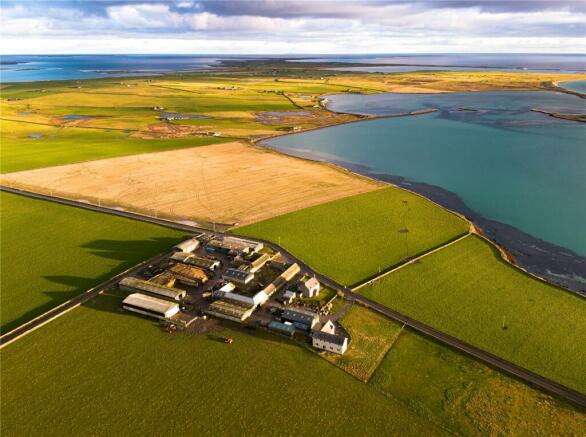
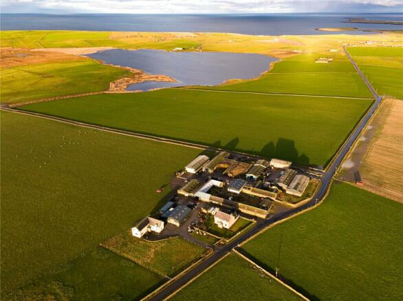
- Extensive range of traditional and modern farm buildings
- 574.66 acres (232.56 hectares) of land
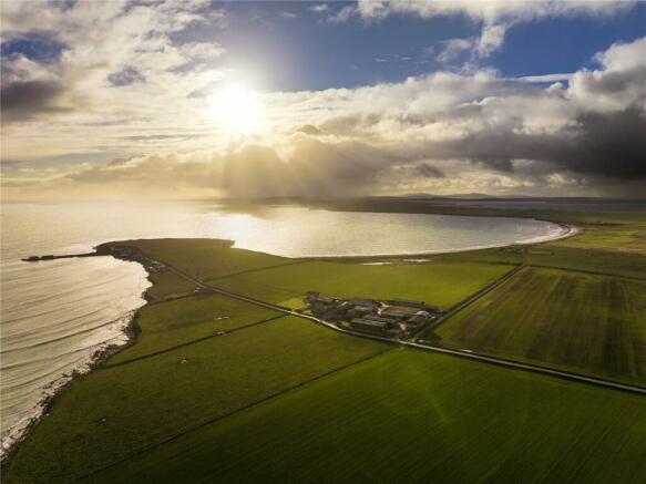
- The Bea Loch & beach frontage
Description
FARMING SYSTEM
Historically, How was farmed in conjunction with the neighbouring unit of Backaskaill. Currently benefitting from the Organic Aid Scheme, How has a carrying capacity of 200 cows and calves, 200 stirks, in addition to 300 breeding ewes. There is an ample land area for the growing of forage and cereal crops to sustain the current stocking rate.
The wider farming business currently benefits from a range of support payments including the Organic Aid Scheme, Basic Payment Scheme, Less Favoured Area Support Scheme, Scottish Beef Calf Scheme and the Agri-Environment Climate Scheme. The payments apportioned to How are forecast to generate an income of £105,000 for the 2024 scheme year.
DIVERSIFICATION POTENTIAL
Included in the ownership of the farm is the Bea Loch, which extends to approximately 95 acres, and 1,250 metres of sea shore on Backaskaill Bay. The potential for diversification opportunities of both is considerable and includes wildlife photography, Orcas often pass through the bay, both sea and loch fishing, sailing and boating in addition to the wild fowling when in season.
BEA NESS FARMHOUSE
A modern, two storey dwelling of timber frame construction being fully insulated throughout. Accommodation comprises as follows:
Ground floor: Kitchen/Diner, Store, Utility, Office, Family Room, Dining Room and Lounge, Toilet
First Floor : Master Bedroom with ensuite, 3 further bedrooms, one with ensuite and Bathroom
EPC C
Council Tax D
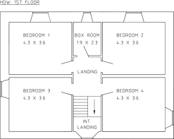
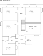
HOW FARMHOUSE
Of traditional stone construction under a slate roof. Accommodation comprises as follows:
Ground Floor: Kitchen, Parlour, Drawing Room, Office, Scullery and Toilet
First Floor: 4 x Bedrooms, Boxroom, Bathroom
EPC F
Council Tax Band C
LAND
The productive farm land extends to 574.66 acres and comprises the land at How, Castlehill and Hammerbrake. In addition there are some 154.34 acres of cliffs, fore shore, roads, yards and buildings, plus 94.79 acres, which comprises the Bea Loch. According to the James Hutton Institute the majority of the land is classified as Grade 4(2) and Grade 5(2). The land is in good heart having been farmed in a grass rotation, with cereal and swede breaks in recent years and is fenced and watered. The land has benefited from regular applications of dung, slurry and shell sand which has a 32.5% lime content.
FARM BUILDINGS
The farm buildings ( see plan) extend to a range of traditional and modern structures as follows:
1. Outbuilding. Stone built under a slate roof.
2. General Purpose Shed (18m x 12m) of steel portal frame construction, corrugated roof, box profile cladding and concrete floor
3. Stables/Kennels of lean-to construction, poured concrete walls and concrete floor
4. Slatted Byre (22.5m x 10.5m) of stee portal frame construction, corrugated roof and poured concrete walls
5. Cattle Handling Byre (39m x 12m) of stone wall construction under a slate roof, concrete floor
6. Cattle Court (45m x 5m) of stone wall construction under a slate roof, concrete floor
7. Shed (15m x 7.5m) of stone wall construction under a slate roof, concrete floor
8. Cattle Court (18m x 10.5m) of steel portal frame construction, corrugated roof, poured concrete walls and concrete floor
9. Tied Byre/Old Barn (33m x 4.8m) of stone built construction under a slate roof
10. The Grain Store (31.5m x 12m) of steel portal frame construction, corrugated roof, poured concrete walls and concrete floor
11. Slatted Court with bedded area (45m x 9.5m) of steel portal frame construction, corrugated roof, poured concrete walls, concrete floor
12. Open Silage Pit (45m x 12m) poured concrete wall construction with concrete floor
13. Open Silage Pit (45m x 4.8m) poured concrete wall construction with concrete floor
14. Open Silage Pit (445m x 10.8m) poured concrete wall construction with concrete floor
15. Loose Court (22.5 x 10.5) of steel portal frame construction, corrugated roof, poured concrete walls and concrete floor
16. Workshop (31.5m x 9.3m) of steel portal frame construction, corrugated roof, profile cladding, poured concrete walls and concrete floor
17. Slatted Byre (31.5m x 12m) of steel portal frame construction, corrugated roof, poured concrete walls and concrete floor
18. Utility Shed (18m x 10.2m) of steel portal frame construction, corrugated roof, box profile cladding, poured concrete walls
19. Bull Housing (12m x 12m) of steel portal frame construction, corrugated roof, box profile cladding, poured concrete walls and concrete floor
20. Dutch Barn (18 x 9.6m) of steel portal frame construction, corrugated roof and earth floor
CASTLEHILL FARM BUILDINGS
1. Cattle Court (18m x 6m) Of steel truss construction, corrugated roof, poured concrete walls and concrete floor.
2. Cattle Court (18m x 6m) Of steel truss construction, corrugated roof, poured concrete walls and concrete floor.
3. Open Silage Pit (34.8m x 10.5m). Poured concrete walls and concrete floor.
4. Slatted Byre (34.8m x 10.5m) Of steel portal frame construction, corrugated roof, poured concrete walls and concrete floor.
SITUATION
Orkney, also known as the Orkney Islands, is an archipelago comprising about 70 islands situated some 10 miles north of the Scottish mainland. Orkney’s largest settlement and also its administrative centre is Kirkwall.
The islands have been inhabited for at least 8,500 years, originally occupied by Mesolithic and Neolithic tribes and then by the Picts. Orkney was colonised and later annexed by the Kingdom of Norway in 875 and settled by the Norseman. In 1472 the parliament of Scotland absorbed the Earldom of Orkney into the Kingdom of Scotland following failure to pay a dowry promised to James III of Scotland by the family of his bride, Margaret of Denmark. The Norse connection with Orkney is strong with many links still in place, including the application of Udal Law.
Orkney contains some of the oldest and best preserved Neolithic sites in Europe. The heart of neolithic Orkney which includes the village of Skara Brae, the Standing Stones of Stenness, the Maeshowe passage grave and the Ring of Brodgar is a designated UNESCO World Heritage Site. Orkney also has an abundance of marine and avian wildlife.
Kirkwall boasts a large number of services including banks, supermarkets, pharmacies, libraries, sports centre and swimming pool, in addition to numerous specialist shops. The area is well resourced in terms of agricultural infrastructure being well served by general merchants, agricultural suppliers and machinery dealers, in addition to Kirkwall Mart.
The soil of Orkney is generally very fertile and most of the land is taken up with farms, agriculture being by far the most important sector of the economy. More than 90% of agricultural land is used for grazing of cattle and sheep.
Sanday is the largest of Orkneys’ outer islands and is well known for its rich, agricultural land and outstanding livestock. The island is well blessed with stunning coastal scenery, long sandy beaches and benefits from high quality convenience shopping and other amenities including primary and secondary schooling, hotels, a medical practice and a dynamic social community scene. There are excellent transport links by sea and air to the mainland.
EPC Rating = C
Brochures
ParticularsEnergy Performance Certificates
Epc How FarmhouseEPC Rating GraphHow Farm, Sanday, Orkney, Orkney Islands, KW17

NEAREST STATIONS
Distances are straight line measurements from the centre of the postcode- Thurso Station55.9 miles
About the agent
Galbraith, Aberdeen
337 North Deeside Road Cults Aberdeen AB15 9SP
Providing outstanding local knowledge, an international client base and 14 offices across Scotland and Northern England, Galbraith is uniquely placed to handle the sale, purchase and letting of residential property throughout Scotland & Northern England. Whether a castle or cottage, townhouse or rural property, sporting estate, farm, land or development, we specialise in top quality residential property.
Galbraith operates with over 200 staff in Aberdeen. Ayr, Blagdon, Castle D
Industry affiliations


Notes
Disclaimer - Property reference ABN240084. The information displayed about this property comprises a property advertisement. Rightmove.co.uk makes no warranty as to the accuracy or completeness of the advertisement or any linked or associated information, and Rightmove has no control over the content. This property advertisement does not constitute property particulars. The information is provided and maintained by Galbraith, Aberdeen. Please contact the selling agent or developer directly to obtain any information which may be available under the terms of The Energy Performance of Buildings (Certificates and Inspections) (England and Wales) Regulations 2007 or the Home Report if in relation to a residential property in Scotland.
Map data ©OpenStreetMap contributors.