Smarden, Ashford, Kent

- PROPERTY TYPE
House
- SIZE
Ask agent
- TENUREDescribes how you own a property. There are different types of tenure - freehold, leasehold, and commonhold.Read more about tenure in our glossary page.
Ask agent
Key features
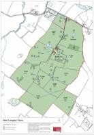
- Ring fenced Wealden Farm
- Planning consent for residential development
- Five bedroom farmhouse
Description
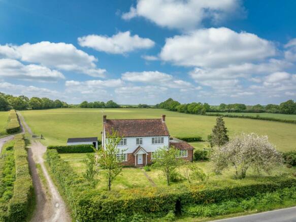
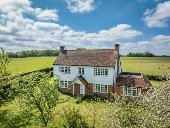
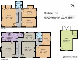
New Langley Farmhouse sits at the northern end of the farm and is built in a traditional style, with brick and weatherboard elevations under a claytiled roof. The farmhouse, which is subject to an agricultural occupancy restriction, has been the subject of gradual improvement over time and is in good condition. On the ground floor is a sitting room, dining room, kitchen, larder, study/breakfast room as well as two further bedrooms and a shower room, which could be used as a separate annexe. The first floor has a principal bedroom with built in wardrobes, two further bedrooms and a family bathroom. Accommodation is bright and well presented, with good views over surrounding countryside. The farmhouse benefits from a separate driveway from the main farm, and is set within an attractive lawned garden, with parking and garage to the rear. There is a paddock of about 4.81 acres (1.95 ha).
Situation
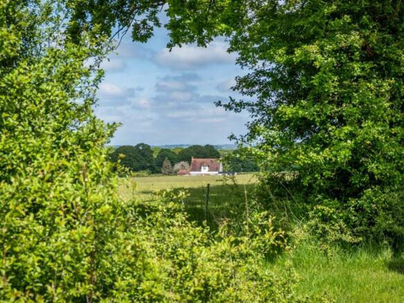
New Langley Farm is situated in an accessible rural location nestled between the villages of Smarden and Bethersden in the heart of Kent. Both villages are well served, with butchers, village Post Offices and pubs, a farm shop, a village hall and a parish church, as well as a primary school. The well-regarded and nearby town of Tenterden offers a wealth of shops, supermarkets, amenities, and leisure facilities, whilst even more extensive retail and leisure activities are situated at Ashford which also benefits from mainline railway station with access to HS1.
Sporting and recreation
There is an abundance of sporting and recreational facilities including golf at Charts Hill Golf Club and Tenterden Golf Club, National Trust properties such as Sissinghurst and a profusion of walks, including Dering Woods and the beach at Camber.
Schools
Nearby schools include those in Ashford (outstanding-rated Highworth Grammar School and the independent Ashford School). The King’s School and others found in Canterbury are easy to access, Benenden; the trains from Pluckley also allow children to attend school in Tonbridge, Sevenoaks and elsewhere if desired.
History
During WW2 the farm formed part of RAF High Halden, a former RAF advanced landing ground which was used by the US Air Force during the run up to the D-Day. It was closed in September 1944 and returned to agricultural land. The position of the runway can still be seen and it is understood that the current buildings at New Langley Farm are positioned on the site of those buildings which may have been used by the US Air Force during this time.
Brochures
Web DetailsParticulars- COUNCIL TAXA payment made to your local authority in order to pay for local services like schools, libraries, and refuse collection. The amount you pay depends on the value of the property.Read more about council Tax in our glossary page.
- Band: TBC
- PARKINGDetails of how and where vehicles can be parked, and any associated costs.Read more about parking in our glossary page.
- Yes
- GARDENA property has access to an outdoor space, which could be private or shared.
- Yes
- ACCESSIBILITYHow a property has been adapted to meet the needs of vulnerable or disabled individuals.Read more about accessibility in our glossary page.
- Ask agent
Energy performance certificate - ask agent
Smarden, Ashford, Kent

NEAREST STATIONS
Distances are straight line measurements from the centre of the postcode- Pluckley Station2.7 miles
- Headcorn Station4.2 miles
About the agent
Strutt & Parker, National Estates & Farm Agency
43 Cadogan Street, London, SW3 2PR
One of the UK’s leading agents in selling, buying and letting town and country houses and cottages, London houses and flats, new homes, farms and estates and residential development land around the country with expert local knowledge backed up by national expertise to ensure a quality service.
Notes
Staying secure when looking for property
Ensure you're up to date with our latest advice on how to avoid fraud or scams when looking for property online.
Visit our security centre to find out moreDisclaimer - Property reference NEF240015. The information displayed about this property comprises a property advertisement. Rightmove.co.uk makes no warranty as to the accuracy or completeness of the advertisement or any linked or associated information, and Rightmove has no control over the content. This property advertisement does not constitute property particulars. The information is provided and maintained by Strutt & Parker, National Estates & Farm Agency. Please contact the selling agent or developer directly to obtain any information which may be available under the terms of The Energy Performance of Buildings (Certificates and Inspections) (England and Wales) Regulations 2007 or the Home Report if in relation to a residential property in Scotland.
*This is the average speed from the provider with the fastest broadband package available at this postcode. The average speed displayed is based on the download speeds of at least 50% of customers at peak time (8pm to 10pm). Fibre/cable services at the postcode are subject to availability and may differ between properties within a postcode. Speeds can be affected by a range of technical and environmental factors. The speed at the property may be lower than that listed above. You can check the estimated speed and confirm availability to a property prior to purchasing on the broadband provider's website. Providers may increase charges. The information is provided and maintained by Decision Technologies Limited. **This is indicative only and based on a 2-person household with multiple devices and simultaneous usage. Broadband performance is affected by multiple factors including number of occupants and devices, simultaneous usage, router range etc. For more information speak to your broadband provider.
Map data ©OpenStreetMap contributors.