Smarden, Ashford, Kent

- PROPERTY TYPE
House
- SIZE
Ask agent
- TENUREDescribes how you own a property. There are different types of tenure - freehold, leasehold, and commonhold.Read more about tenure in our glossary page.
Ask agent
Key features
- Ring fenced Wealden Farm
- Planning consent for residential development
- Five bedroom farmhouse
Description
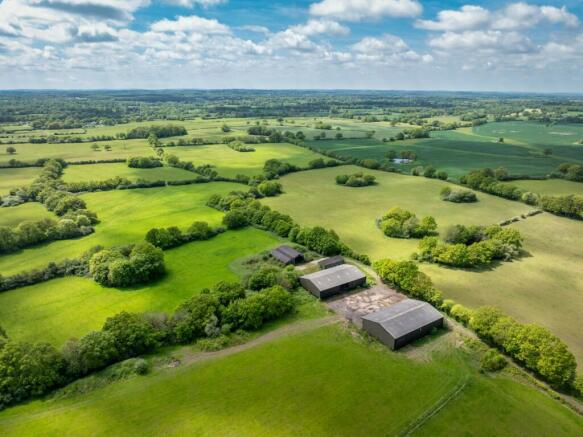
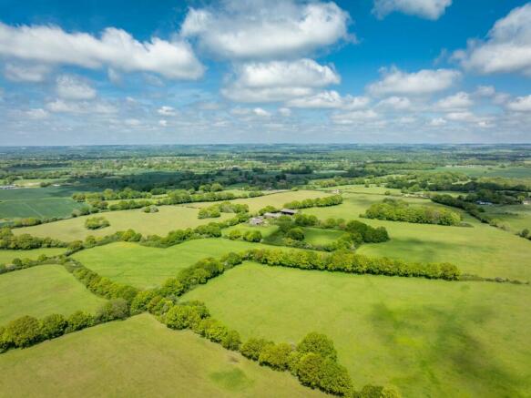
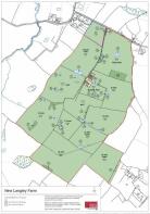
Extending to approximately 172.65 acres (69.87 ha) in all, the farm comprises an exceptionally rare combination of farmhouse, land, buildings and consented development opportunities, within a single ring fence and offering total privacy and seclusion, well away from any neighbours or road noise. There are no public rights of way crossing the farm and the positioning of the farm buildings with development opportunities is central to the property providing a fantastic base for further development.
Lot 1 – New Langley Farm
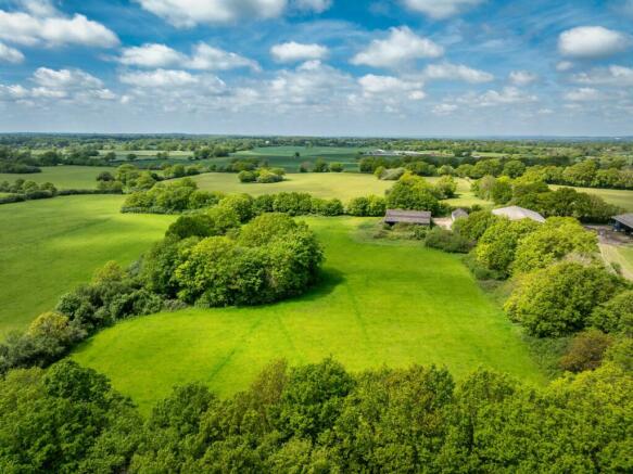
The entire farm sits in a ring fence with a group of modern and more traditional farm buildings sitting at its heart. There is one principal point of access on the northern boundary from the Bethersden Road, with a good metalled farm track running south to the farm buildings. The more modern farm buildings each extend to approximately 6,000 sq ft (557 sq m) and are situated around a central yard. These two barns are of box-corrugated elevations and are currently used for hay storage. Beyond the modern farm buildings are a range of older barns that have had minimal use in recent times, and may in part have been built when the farm was briefly used as a US Air Force base in WW2. These buildings are the site on which planning consent was granted for the development of two brand new dwellings. The principal new house will comprise principal bedroom suite with bathroom and dressing room, three further en-suite bedrooms, family bathroom, study/fifth bedroom, lobby and utility on the ground floor. On the first floor will be a TV room/snug, separate study and very spacious open plan sitting/dining/ kitchen, with glazed conservatory area and doors onto a roof terrace. When completed, this architecturally striking, barn-style house will have fantastic views over surrounding land, offering total peace and seclusion. The second planning consent is for the replacement of the smaller barn (barn B) which lies to the north west of the main plot, with a single storey two-bedroom barn-style house. This second smaller barn would be ideal for use as an annexe, holiday let or staff accommodation to serve the larger house. A Part Q consent was subsequently granted for the conversion of one of the modern barns to comprise a pair of semi detached units. It is thought these consents collectively form a good basis for future development.
The Land
The land at New Langley farm comprises 11 main fields intersected by mature hedgerows, and interspersed with natural ponds and mature oaks, giving it an attractive parkland feel. It is understood that most of the larger fields were formerly in arable production. However, in more recent years, the land has been managed for either a hay or haylage crop. Some of the land has been seasonally grazed by a local sheep farmer but this is a short-term arrangement and the land would be sold with vacant possession. On the edge of the northern-most field is a block of traditional broadleaf coppice woodland,
which is filled with bluebells each spring. This combination of varied habitats provides an abundance of wildlife with vast range of species.
Lot 2 – New Langley Farmhouse
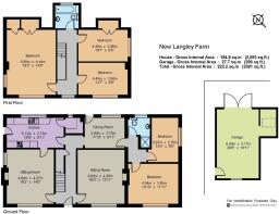
New Langley Farmhouse sits at the northern end of the farm and is built in a traditional style, with brick and weatherboard elevations under a claytiled roof. The farmhouse, which is subject to an agricultural occupancy restriction, has been the subject of gradual improvement over time and is in good condition. On the ground floor is a sitting room, dining room, kitchen, larder, study/breakfast room as well as two further bedrooms and a shower room, which could be used as a separate annexe. The first floor has a principal bedroom with built in wardrobes, two further bedrooms and a family bathroom. Accommodation is bright and well presented, with good views over surrounding countryside. The farmhouse benefits from a separate driveway from the main farm, and is set within an attractive lawned garden, with parking and garage to the rear. There is a paddock of about 4.81 acres (1.95 ha).
Farm buildings
A buildings plan is provided showing gross external areas. The two principal farm buildings are of relatively modern portal framed construction with box corrugated elevations under corrugated roofs. The more traditional farm buildings are of concrete portal frame construction under corrugated asbestos roofs.
Farming
The holding is farmed in hand. Whilst much of the land was historically in arable production the farmland is now all in pasture and has been managed for hay and haylage crops for many years.
Woodland
There are small blocks of amenity woodland and wooded shaws, many containing ponds, situated around the holding. These are predominantly comprised of hornbeam, with some large mature oaks and other native trees.
Sporting
Sporting rights are in-hand and not currently used.
Planning
There is planning permission for 906 square meters of residential accommodation on the site of the farm buildings at the centre of the yard, comprising four units. This includes detailed planning consent for the replacement of the more traditional farm buildings with two new build houses in a modern barn style, as well as a Class Q consent for the partial conversion of the northernmost of the modern farm buildings into a pair of semi detached houses. Some drawings were prepared for a four unit new build scheme, but it is also thought that the site may be suitable for a single new build country house, subject to obtaining all necessary consents. A full planning history is available from the selling agents.
Situation
New Langley Farm is situated in an accessible rural location nestled between the villages of Smarden and Bethersden in the heart of Kent. Both villages are well served, with butchers, village Post Offices and pubs, a farm shop, a village hall and a parish church, as well as a primary school. The well-regarded and nearby town of Tenterden offers a wealth of shops, supermarkets, amenities, and leisure facilities, whilst even more extensive retail and leisure activities are situated at Ashford which also benefits from mainline railway station with access to HS1.
Sporting and recreation
There is an abundance of sporting and recreational facilities including golf at Charts Hill Golf Club and Tenterden Golf Club, National Trust properties such as Sissinghurst and a profusion of walks, including Dering Woods and the beach at Camber.
Schools
Nearby schools include those in Ashford (outstanding-rated Highworth Grammar School and the independent Ashford School). The King’s School and others found in Canterbury are easy to access, Benenden; the trains from Pluckley also allow children to attend school in Tonbridge, Sevenoaks and elsewhere if desired.
History
During WW2 the farm formed part of RAF High Halden, a former RAF advanced landing ground which was used by the US Air Force during the run up to the D-Day. It was closed in September 1944 and returned to agricultural land. The position of the runway can still be seen and it is understood that the current buildings at New Langley Farm are positioned on the site of those buildings which may have been used by the US Air Force during this time.
Brochures
Web DetailsParticulars- COUNCIL TAXA payment made to your local authority in order to pay for local services like schools, libraries, and refuse collection. The amount you pay depends on the value of the property.Read more about council Tax in our glossary page.
- Band: TBC
- PARKINGDetails of how and where vehicles can be parked, and any associated costs.Read more about parking in our glossary page.
- Yes
- GARDENA property has access to an outdoor space, which could be private or shared.
- Yes
- ACCESSIBILITYHow a property has been adapted to meet the needs of vulnerable or disabled individuals.Read more about accessibility in our glossary page.
- Ask agent
Energy performance certificate - ask agent
Smarden, Ashford, Kent

NEAREST STATIONS
Distances are straight line measurements from the centre of the postcode- Pluckley Station2.7 miles
- Headcorn Station4.2 miles
About the agent
Strutt & Parker, National Estates & Farm Agency
43 Cadogan Street, London, SW3 2PR
One of the UK’s leading agents in selling, buying and letting town and country houses and cottages, London houses and flats, new homes, farms and estates and residential development land around the country with expert local knowledge backed up by national expertise to ensure a quality service.
Notes
Staying secure when looking for property
Ensure you're up to date with our latest advice on how to avoid fraud or scams when looking for property online.
Visit our security centre to find out moreDisclaimer - Property reference NEF220027. The information displayed about this property comprises a property advertisement. Rightmove.co.uk makes no warranty as to the accuracy or completeness of the advertisement or any linked or associated information, and Rightmove has no control over the content. This property advertisement does not constitute property particulars. The information is provided and maintained by Strutt & Parker, National Estates & Farm Agency. Please contact the selling agent or developer directly to obtain any information which may be available under the terms of The Energy Performance of Buildings (Certificates and Inspections) (England and Wales) Regulations 2007 or the Home Report if in relation to a residential property in Scotland.
*This is the average speed from the provider with the fastest broadband package available at this postcode. The average speed displayed is based on the download speeds of at least 50% of customers at peak time (8pm to 10pm). Fibre/cable services at the postcode are subject to availability and may differ between properties within a postcode. Speeds can be affected by a range of technical and environmental factors. The speed at the property may be lower than that listed above. You can check the estimated speed and confirm availability to a property prior to purchasing on the broadband provider's website. Providers may increase charges. The information is provided and maintained by Decision Technologies Limited. **This is indicative only and based on a 2-person household with multiple devices and simultaneous usage. Broadband performance is affected by multiple factors including number of occupants and devices, simultaneous usage, router range etc. For more information speak to your broadband provider.
Map data ©OpenStreetMap contributors.