Foxton, Market Harborough, Leicestershire

- PROPERTY TYPE
House
- SIZE
Ask agent
- TENUREDescribes how you own a property. There are different types of tenure - freehold, leasehold, and commonhold.Read more about tenure in our glossary page.
Ask agent
Key features
- A grade II listed three storey farmhouse
- Kitchen, dining room and sitting room
- Three bedrooms and family bathroom
- Accommodation extending to about 2,626 sq.ft
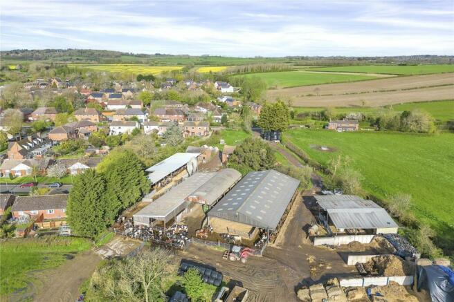
- A range of traditional & modern livestock farm buildings About 21,565 sq.ft. with scope for alternative uses (STP)
- Productive permanent pasture land in a ring-fence
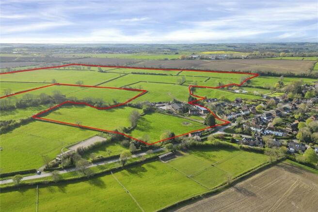
- In all about 101.67 acres (41.15 ha)
- For Sale freehold, as a whole, subject to tenancy
- Excellent access to Market Harborough
Description
An exciting opportunity to purchase a ringfenced dairy farm, occupied under an Agricultural Holdings Act (1986) Tenancy, on the edge of Foxton village.
For Sale freehold, as a whole, subject to tenancy.
Property Overview
• Three-storey, three-bedroom grade II listed farmhouse extending to about 2,626 sq.ft.
• Range of traditional and modern livestock farm buildings extending to about 21,565 sq.ft. with scope for alternative uses (STP).
• Productive permanent pasture land in a ring-fence.
• In all about 101.67 acres (41.15 ha).
• For Sale Freehold subject to an Agricultural Holdings Act Tenancy.
Situation
Schofields Farm is situated to the east of Foxton village in South Leicestershire, with excellent access to the market town of Market Harborough (3.8 miles), Leicester (14 miles) and Northampton (25 miles).
Market Harborough is an attractive market town offering an array of superb facilities to include boutique and independent stores, supermarkets, restaurants and bars, a leisure centre and theatre.
From Market Harborough train station, there is a mainline service with direct trains to London St Pancras taking approximately 60 minutes.
Nearby is Foxton Locks as well as many popular village pubs and restaurants. Schooling is the area is excellent with highly regarded primary and secondary schools in the town as well as some fantastic independent schools on the doorstep to include Spratton Hall, Maidwell Hall as well as Oakham and Uppingham.
Description
The farm provides a rarely available rural investment opportunity to acquire a fully equipped dairy farm in a most sought-after location in south Leicestershire.
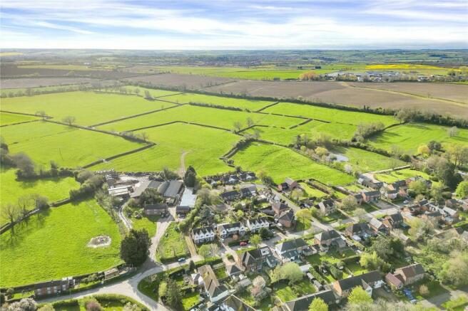
Schofields Farm extends to about 101.67 acres (41.15 ha) in a ring-fence, comprising a three-storey three bedroom listed farmhouse, a range of traditional and modern farm buildings, and permanent pasture land. The property is available as a whole.
Access to the farm is provided from Swingbridge Street.
Farmhouse
The farmhouse dates back to circa. 1749, and comprises a grade II listed three-storey property extending to about 2,626 sq.ft., in addition to a cellar. The farmhouse is listed under entry number: 1061463.
The farmhouse is of brick construction under concrete roof tiles, is in reasonable order throughout and would benefit from a programme of modernisation.
The ground floor comprises; entrance hall and porch, farmhouse kitchen with fitted floor and wall units with wood fired stove and quarry tile flooring, dining room, and sitting room with open fire.
The first floor comprises; landing area, master bedroom, two further double bedrooms, family bathroom with shower over bath, wc and basin, and a small dressing room.
The second floor comprises three attic rooms with restricted access.
Heating is by way of electric storage heaters and the property is principally singled glazed.
Single glazed, some secondary glazing.
The farmhouse benefits from a small rear and side garden laid mainly to lawn with some borders and hedges.
EPC: N/A
Council Tax Band: E
Modern & Traditional Farm Buildings
The farm buildings range in description and age and are currently supporting a dairy enterprise. A number of the farm buildings are tenants owned/ tenants’ fixtures.
The majority of buildings benefit from electricity and water connections, in addition to a three-phase supply.
Land Type and Cropping History
A ring-fenced block of productive and generally level pastureland in a number of field parcels. The land has historically been utilised for livestock grazing and mowing.
Access to the farmland is principally from the farm buildings. There is a secondary access to the western boundary off Swingbridge Street.
The field parcels are generally bound by mature hedgerow and post and wire fencing (in part). Water is connected and supplied via a number of plastic and concrete water troughs.
The southern land boundary abuts the Grand Union Canal
The land is classified as Grade 3 according to Natural England’s Land Classification Maps. The soils are classified in the Soil Maps of England and Wales as being part of the Wickham series and may be described as slightly acidic, loamy, and clayey texture with impeded drainage. Such soils are well suited to grass production for dairying or beef.
There are small areas of woodland within the overall acreage and a number of footpaths cross the land as shown on the sale plan.
Tenure and Possession
The freehold of the property is for sale and is subject to an Agricultural Holdings Act 1986 Tenancy. The secure tenancy commenced on 10th October 1935, with a first succession taking place on 10th October 2004. One further succession to the tenancy may therefore be available.
A copy of the tenancy and first succession agreement is available upon request to seriously interested parties.
Rent
The passing rent for the property subject to the Agricultural Holdings Act tenancy is £9,000 per annum. The rent was last reviewed in 2012.
Rights of Way, Wayleaves, and Easements
A number of public rights of way cross the property and are shown on the sale plan.
The property is subject to a vehicular right of way to the north of the farm buildings for the benefit of a neighbouring landowner.
The property has the benefit of a right of way, believed to be for agricultural purposes only, through adjoining land to the north of the farm.
There are four telegraph poles and overhead line running eats to west across the farm.
The property is sold subject to all rights of way, wayleaves, and easements whether or not they are defined in this brochure.
Plans and Boundaries
The plans within these particulars are based on Ordnance Survey data and provided for reference only. They are believed to be correct, but accuracy is not guaranteed. The purchaser shall be deemed to have full knowledge of all boundaries and the extent of ownership. Neither the vendor nor the vendor’s agents will be responsible for defining the boundaries or the ownership thereof.
Mineral, sporting, and timber rights
The sporting, mineral and timber rights will be transferred with the freehold title where owned.
Conservation Area
The farmhouse, buildings, and part of the land sit within Foxton Conservation Area.
Flood Risk
Parts of the property lie within Flood Zones 2 and 3.
Nitrate Vulnerable Zone (NVZ)
The Property lies within a Surface Water NVZ Area and is subject to the usual restrictions.
Basic Payment Scheme and Environmental Schemes
The land has historically been registered for payments under the Basic Payment Scheme and all delinked payments and entitlements relevant to the land will be retained by the tenant and will not be available to the Purchaser on completion of the sale. There are not believed to be any environmental schemes in place.
Value Added Tax (VAT)
Any guide price quoted or discussed is exclusive of VAT. In the event that a sale of the property or any part thereof or any right to it becomes a chargeable supply for the purposes of VAT, such tax will be payable in addition to the sale price.
Ingoing Crop Valuation/ Holdover)
No ingoing valuation will be required.
Overage
The farm buildings and farm yard area will be sold subject to an uplift provision which will specify that 25% of any increase in value due to development (as defined in Section 55 of the Town and Country Planning Act 1990) will be payable to the Vendors or their successors in title should such development occur within 25 years from the date of completion. The uplift will be payable upon implementation or on a future sale with the benefit of a planning consent. The overage will exclude any development for agricultural and/or equestrian use.
The farmland will be sold subject to an uplift provision which will specify that 25% of any increase in value due to development (as defined in Section 55 of the Town and Country Planning Act 1990) for renewable energy purposes only will be payable to the Vendors or their successors in title should such development occur within 25 years from the date of completion. The uplift will be payable upon implementation or on a future sale with the benefit of a planning consent.
The farmhouse is excluded from any proposed overage provision.
Successive grants of permission within the terms set out above would trigger overage. Reasonable costs incurred in obtaining planning permissions can be deducted from the overage calculations.
Local Authority
Harborough District Council.
Fixtures and Fittings
All Landlords fixtures and fittings are included in the sale.
Services
Mains water and electricity are connected. Heating is via electric storage heaters. Drainage is to a private aerobic digester. The farm buildings benefit from a three phase power supply.
The estimated fastest download speed currently achievable for the property postcode area is around 80 Mbps (data taken from checker.ofcom.org.uk on 13/05/2024). Actual service availability at the property or speeds received may be different.
We understand that the property is likely to have current mobile coverage outdoors (data taken from checker.ofcom.org.uk on 13/05/2024). Please note that actual services available may be different depending on the particular circumstances, precise location and network outages.
Prospective Purchasers must satisfy themselves as to the availability of services and any future connections. None of the services, appliances or electrical systems have been tested by the selling agents.
Solicitors
Roythornes Solicitors, Enterprise Way, Pinchbeck, Spalding, Lincolnshire, PE11 3YR
FAO: Elizabeth Young
Viewings
Strictly by appointment through Fisher German LLP.
Directions
Postcode – LE16 7RH
What3words ///faces.perfumed.locked
Brochures
Particulars- COUNCIL TAXA payment made to your local authority in order to pay for local services like schools, libraries, and refuse collection. The amount you pay depends on the value of the property.Read more about council Tax in our glossary page.
- Band: TBC
- PARKINGDetails of how and where vehicles can be parked, and any associated costs.Read more about parking in our glossary page.
- Ask agent
- GARDENA property has access to an outdoor space, which could be private or shared.
- Yes
- ACCESSIBILITYHow a property has been adapted to meet the needs of vulnerable or disabled individuals.Read more about accessibility in our glossary page.
- Ask agent
Energy performance certificate - ask agent
Foxton, Market Harborough, Leicestershire
NEAREST STATIONS
Distances are straight line measurements from the centre of the postcode- Market Harborough Station2.9 miles


Fisher German is a dynamic, multi-disciplined firm of chartered surveyors and estate agents, offering an extensive range of services to buyers and sellers of property across much of England and Wales. The firm has been offering professional services in all aspects of land and property for over 180 years.
We know that achieving a good sale is about creating and delivering a carefully considered strategy using a skillful blend of marketing to communicate with the target audience. Our campaigns include telephone contact, creative advertising and PR, postal mailings, extensive website listings and social media promotions. We leave no avenue for promotion unexplored, and our clients find this combination of initiatives incredibly effective. As well as matching buyers to properties and agreeing a sale, we work tirelessly to ensure that the sale continues through to completion. This is particularly important when market conditions may be more complex than usual. We understand exactly what it takes to ensure that a sale completes and our fall-through rate is exceptionally low.
Above all, we pride ourselves on our impeccable service. Contact us to see what we can do for you.
Notes
Staying secure when looking for property
Ensure you're up to date with our latest advice on how to avoid fraud or scams when looking for property online.
Visit our security centre to find out moreDisclaimer - Property reference NCT220079. The information displayed about this property comprises a property advertisement. Rightmove.co.uk makes no warranty as to the accuracy or completeness of the advertisement or any linked or associated information, and Rightmove has no control over the content. This property advertisement does not constitute property particulars. The information is provided and maintained by Fisher German, Covering the Midlands. Please contact the selling agent or developer directly to obtain any information which may be available under the terms of The Energy Performance of Buildings (Certificates and Inspections) (England and Wales) Regulations 2007 or the Home Report if in relation to a residential property in Scotland.
*This is the average speed from the provider with the fastest broadband package available at this postcode. The average speed displayed is based on the download speeds of at least 50% of customers at peak time (8pm to 10pm). Fibre/cable services at the postcode are subject to availability and may differ between properties within a postcode. Speeds can be affected by a range of technical and environmental factors. The speed at the property may be lower than that listed above. You can check the estimated speed and confirm availability to a property prior to purchasing on the broadband provider's website. Providers may increase charges. The information is provided and maintained by Decision Technologies Limited. **This is indicative only and based on a 2-person household with multiple devices and simultaneous usage. Broadband performance is affected by multiple factors including number of occupants and devices, simultaneous usage, router range etc. For more information speak to your broadband provider.
Map data ©OpenStreetMap contributors.


