23.25 Acres of Land at Parwich
- PROPERTY TYPE
Land
- SIZE
1,012,770 sq ft
94,089 sq m
Key features
- 23.25 Acres or Thereabouts
- With the Remains of a Small Stone Building
- Main Water Connected
Description
Situation - The land is situated within the village of Parwich which lies approximately 7 miles from Ashbourne. The land lies to the rear of Sycamore Cottages and is accessed by means of a stone trackway, which is shown on the land registry title which is attached.
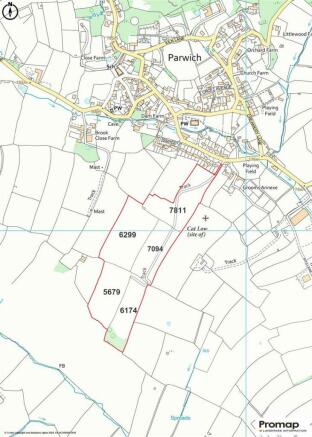
The location of the land is shown on the attached plan.
What3Words Location Code: ///somewhere.crumples.assess
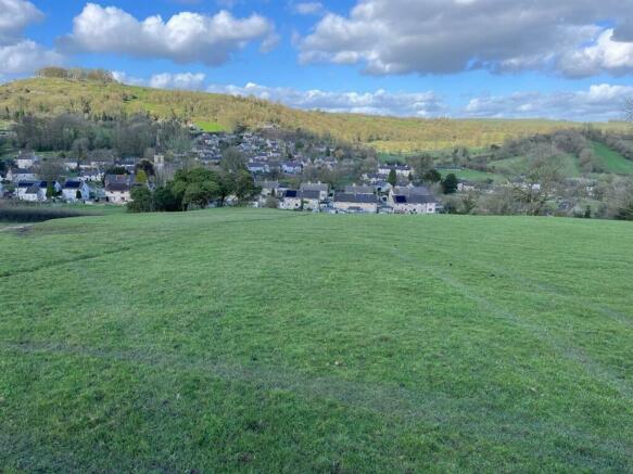
Description - The land comprises a block of undulating grassland, a good proportion of which is suitable for mowing as well as grazing purposes. It is all considered to be sound in nature and capable of growing good crops of grass.
There are the remains of a small stone buiding on the land between OS7811 and OS6299. Within the land there is a natural spring that does provide some water facilities for livestock. Interested parties should make their own inspection.
At the southern end of the land there is a small area of open bushes and small trees.
The land is further described in the following schedule:-
OS Field NumberDescription Area (hectares)
7811 Grassland 2.09
6299 Grassland 2.43
7094 Grassland 1.56
5679 Grassland 1.74
6174 Grassland 1.57
- Trackway 0.02
9.41 hectares or
23.25 acres or thereabouts
Services - The land is connected to a mains water supply.
Land Registry - The property is held on the land registry under title number DY389539, a copy of which is attached.
Tenure & Possession - The land is held freehold and vacant possession will be given upon completion.
Local Authority - The local authority is Derbyshire Dales District Council to whom interested parties should make their enquiries of planning or other relevant matters.
Overage Clause - The land is offered for sale subject to an overage clause for the benefit of the previous owners which provides for a payment to them of 50% of any uplift in value of the land due to planning for any none agricultural development. This clause is dated 12th May 2005 and is for a period of 25 years.
Please note also that the present owners are offering the land on the basis of a further overage clause in their favour effective from 12th May 2030 ie after the present one runs out of time which will provide for a payment to them of 30% of any uplift in value of the land due to planning for any none agricultural development, this will run for a further 25 years.
This payment will be due when planning is implemented.
Viewings - At any reasonable time with a set of these particulars
Mapping - The plans provided in these particulars are indicative and for identification purposes
Wayleaves And Easements - The land is sold subject to and with the benefits of all rights, including rights of way, whether public or private, light, support, drainage, water and electricity supplies and other rights and obligations, easements, quasieasements and restrictive covenants and all existing and proposed wayleaves for masts, pylons, stays, cables, drains and water, whether or not referred to in these stipulations, the particulars or special conditions of sale.
Brochures
Particulars -Land to the rear of Sycamore Cottages23.25 Acres of Land at Parwich
NEAREST STATIONS
Distances are straight line measurements from the centre of the postcode- Matlock Bath Station7.2 miles
Notes
Disclaimer - Property reference 33106412. The information displayed about this property comprises a property advertisement. Rightmove.co.uk makes no warranty as to the accuracy or completeness of the advertisement or any linked or associated information, and Rightmove has no control over the content. This property advertisement does not constitute property particulars. The information is provided and maintained by Graham Watkins, Leek. Please contact the selling agent or developer directly to obtain any information which may be available under the terms of The Energy Performance of Buildings (Certificates and Inspections) (England and Wales) Regulations 2007 or the Home Report if in relation to a residential property in Scotland.
Map data ©OpenStreetMap contributors.


