Sutton-On-Trent, Newark, Nottinghamshire

- SIZE
Ask agent
- TENUREDescribes how you own a property. There are different types of tenure - freehold, leasehold, and commonhold.Read more about tenure in our glossary page.
Ask agent
Description
For sale as a whole at a guide price of £175,000
SITUATION
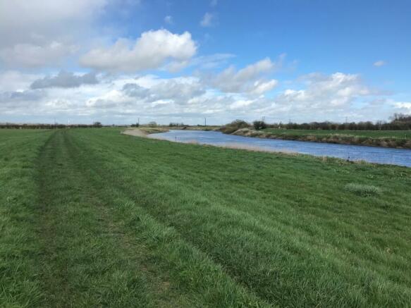
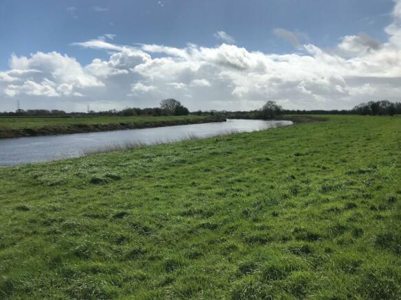
The land is located on the banks of the River Trent on the edge of Sutton-on-Trent, with the regional centres of Newark and Lincoln nearby. The property is accessed via Far Holme Lane, an unmade track.
DESCRIPTION
The land, coloured red on the plan, extends in total to approximately 10.75 hectares (26.56 acres) and comprises two parcels of grassland with fishing rights. The land is classified as Grade 3 according to the Agricultural Land Classification Maps for England and Wales and is currently subject to a Countryside Stewardship Application ending in December 2024.
The land is laid to permanent pasture and has been grazed on an annual licence. Further details are available from the agent.
Parts of the property are occupied under a fishing licence with an annual licence fee of £700, which includes the riverbanks of the River Trent and a parking area for up to six vehicles. A copy of this licence is available from the agent.
GENERAL
METHOD OF SALE
The property is offered for sale by private treaty as a whole.
TENURE
The land is for sale freehold subject to the existing licences.
SERVICES
There are no mains services connected to the land.
WAYLEAVES, EASEMENTS AND RIGHTS OF WAY
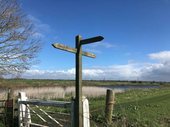
The property is sold subject to and with the benefit of all rights. A number of footpaths run adjacent to or across the land. Further details are available from the agent.
BASIC PAYMENT SCHEME
Entitlements are not included in the sale.
COUNTRYSIDE STEWARDSHIP SCHEME
The land is subject to a Lowland Grazing Countryside Stewardship agreement (ref. AG718455) ending on 21/12/2024.
OVERAGE
The Vendors and their successors in title, will retain 30% of any uplift in value as a result of any planning permission other than for agricultural use for a period of 40 years from completion of the sale. The Overage will be payable upon implementation of the permission or upon a sale of the property with the benefit of said permission, whichever is earlier.
DESIGNATIONS
The land is within a Nitrate Vulnerable Zone (Surface Water S320) and within a SSI Impact Risk Zone.
SPORTING, TIMBER AND MINERAL RIGHTS
All sporting, timber and mineral rights are included in the freehold sale, in so far as they are owned.
DRAINAGE RATES
The land lies within the Trent Valley Internal Drainage Board and drainage rates are payable to this authority. For 2022/23 these were £164.35.
DIRECTIONS
Please see location plan within the particulars.
//what3words:files.fizzle.eternally
FURTHER INFORMATION
Please contact the agents - Rob Wilkinson
rob.
at the Stamford office for further information.
VIEWING
Strictly by appointment with the Vendor's agent, Strutt & Parker in Stamford - .
SOLICITOR
Tallents Solicitors, 3 Middle Gate, Newark, Nottinghamshire, NG24 1AQ
For the attention of Alistair Miller
Email: alistair.
Tel:
Brochures
Web DetailsParticulars- COUNCIL TAXA payment made to your local authority in order to pay for local services like schools, libraries, and refuse collection. The amount you pay depends on the value of the property.Read more about council Tax in our glossary page.
- Band: TBC
- PARKINGDetails of how and where vehicles can be parked, and any associated costs.Read more about parking in our glossary page.
- Yes
- GARDENA property has access to an outdoor space, which could be private or shared.
- Ask agent
- ACCESSIBILITYHow a property has been adapted to meet the needs of vulnerable or disabled individuals.Read more about accessibility in our glossary page.
- Ask agent
Energy performance certificate - ask agent
Sutton-On-Trent, Newark, Nottinghamshire

NEAREST STATIONS
Distances are straight line measurements from the centre of the postcode- Collingham Station3.4 miles
- Swinderby Station4.3 miles
About the agent
Strutt & Parker, Stamford Rural
5 South View Business Park, Tinwell Road, Stamford, PE9 2JL
Notes
Staying secure when looking for property
Ensure you're up to date with our latest advice on how to avoid fraud or scams when looking for property online.
Visit our security centre to find out moreDisclaimer - Property reference STF230007. The information displayed about this property comprises a property advertisement. Rightmove.co.uk makes no warranty as to the accuracy or completeness of the advertisement or any linked or associated information, and Rightmove has no control over the content. This property advertisement does not constitute property particulars. The information is provided and maintained by Strutt & Parker, Stamford Rural. Please contact the selling agent or developer directly to obtain any information which may be available under the terms of The Energy Performance of Buildings (Certificates and Inspections) (England and Wales) Regulations 2007 or the Home Report if in relation to a residential property in Scotland.
*This is the average speed from the provider with the fastest broadband package available at this postcode. The average speed displayed is based on the download speeds of at least 50% of customers at peak time (8pm to 10pm). Fibre/cable services at the postcode are subject to availability and may differ between properties within a postcode. Speeds can be affected by a range of technical and environmental factors. The speed at the property may be lower than that listed above. You can check the estimated speed and confirm availability to a property prior to purchasing on the broadband provider's website. Providers may increase charges. The information is provided and maintained by Decision Technologies Limited. **This is indicative only and based on a 2-person household with multiple devices and simultaneous usage. Broadband performance is affected by multiple factors including number of occupants and devices, simultaneous usage, router range etc. For more information speak to your broadband provider.
Map data ©OpenStreetMap contributors.