Land At, Gas House Drove, Brandon, Suffolk, IP27 0EB
- SIZE AVAILABLE
31,799 sq ft
2,954 sq m
- SECTOR
Land for sale
Key features
- Close to Thetford Forest
- Popular village
- No affordable housing
Description
Popular village
No affordable housing
RESIDENTIAL DEVELOPMENT SITE WITH FULL PLANNING PERMISSION FOR 9 DWELLINGS
RESIDENTIAL DEVELOPMENT SITE WITH FULL PLANNING PERMISSION FOR 9 DWELLINGS
Detailed Description
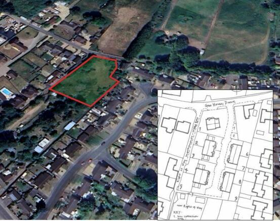
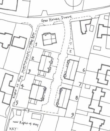
The site has full planning permission reference: DC/22/1608/RM from West Suffolk Council which followed an outline planning permission of DC/19/1616/OUT for nine dwellings.
Plot 1 is a four bed detached house with garage extending to 1700 sq ft. Plots 2&3 are three bed semi-detached houses with garages extending to 1300 sq ft. Plots 4 & 5 are four bed semi-detached houses with garages extending to 1510 sq ft and plots 6&7 and 8&9 are two bed semi-detached bungalows extending to 657 sq ft.
This provides a total of sq ft GIA of 10,020 sq ft giving an attractive mix of dwellings that should be of interest to purchasers.
The site provides parking for 25 cars for the 9 houses.
There are several plans and reports attached to both planning permissions including:
Two decision notices
Proposed site plan
All floor plans and elevations
Topographical survey
Phase 1 contamination report
Reptile survey
Ecology survey
Public right of way site map
There is no CIL liability or S106
Location
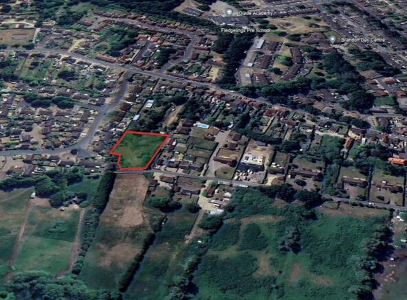
Brandon is a popular village in northwest Suffolk within West Suffolk District Council, close to the border with Norfolk. It lies next to Thetford Forest between Bury St Edmunds, Thetford and Mildenhall.
The site is situated on Gas House Drove to the northeast of the village at its junction with Webb's Row.
The site is rectangular in shape and extends to 0.29 hectares (0.73 acres).
Strictly by appointment with the sole selling agent:-
VAT will not be charged on the sale.
Each party will be responsible for their own legal costs in the transaction.
Brochures
Land At, Gas House Drove, Brandon, Suffolk, IP27 0EB

NEAREST STATIONS
Distances are straight line measurements from the centre of the postcode- Brandon Station0.5 miles
- Lakenheath Station4.2 miles
- Thetford Station5.1 miles
About Brown & Co, Norwich
The Atrium St. Georges Street, Norwich, NR3 1AB
Notes
Disclaimer - Property reference 442218FH. The information displayed about this property comprises a property advertisement. Rightmove.co.uk makes no warranty as to the accuracy or completeness of the advertisement or any linked or associated information, and Rightmove has no control over the content. This property advertisement does not constitute property particulars. The information is provided and maintained by Brown & Co, Norwich. Please contact the selling agent or developer directly to obtain any information which may be available under the terms of The Energy Performance of Buildings (Certificates and Inspections) (England and Wales) Regulations 2007 or the Home Report if in relation to a residential property in Scotland.
Map data ©OpenStreetMap contributors.