Land At Long Lane, Gamlingay, Sandy, Cambridgeshire, SG19 3ES
£0.21 per sq ft
Business rates & charges may apply

- SIZE AVAILABLE
14,527,260 sq ft
1,349,628 sq m
- SECTOR
Farm land for sale
Key features
- Located north east of the village of Gamlingay in Cambridgeshire
- A ring-fenced block of arable land which is shown as being predominantly Grade 2
- Small area of Grade 1 agricultural land in the south west corner of the block
- For Sale as a Whole by Private Treaty
Description
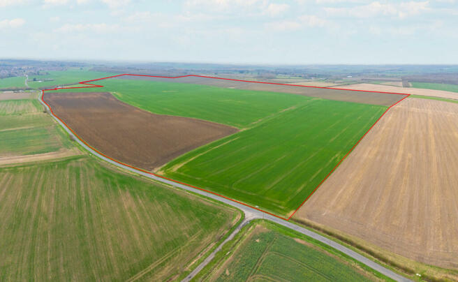
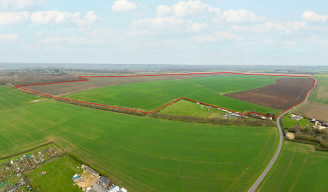
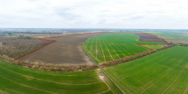
An exciting opportunity to purchase a ring-fenced block of productive arable land located on the Cambridgeshire/Bedfordshire border extending to approximately 134.97 hectares (333.50 acres).
LOCATION AND SITUATION
The property is located north east of the village of Gamlingay in Cambridgeshire, approximately 5 miles north east of the town of Sandy, 7 miles south east of St Neots and 16 miles south west of the city of Cambridge.
Nearest postcode: SG19 3ES
what3words: ///reserving.coughed.fonts or ///professes.lends.configure
FARMLAND
A ring-fenced block of arable land which is shown as being predominantly Grade 2 on the Ministry of Agriculture Land Classification Sheet (with a small area of Grade 1 agricultural land in the south west corner of the block). The soil survey of England and Wales identifies the Land as being part of the Evesham 3 soil series which is described as being lime-rich loamy and clayey soils capable of growing cereals and other combinable crops. The south west corner of the Land is also identified as being part of the Bearsted 1 soil series which is described as being freely draining slightly acid loamy soils.
ACCESS
The Land has road frontage and direct access onto the public highway being Long Lane via two field gateways with lockable barriers.
GENERAL REMARKS & STIPULATIONS METHOD OF SALE
The Land is offered for sale by Private Treaty as a whole. The Vendor reserves the right to conclude the sale by an alternative method, at their discretion.
The Purchaser will be required to exchange contracts within 28 working days of receipt by the Purchasers solicitor of a draft contract, with completion by arrangement. A 10% deposit will be payable upon the exchange of contracts.
TENURE
The Land is being sold freehold with the benefit of vacant possession.
HOLDOVER
The Vendor reserves the right to holdover for the purposes of harvesting crops and straw clearance until 30th September 2024.
INGOING
The Purchaser will be required to pay an additional sum for any cultivations or crops unable to be harvested post 30th September 2024.
EARLY ENTRY
Early entry onto the land may be available following the exchange of contracts subject to a 20% deposit and entirely at the Purchaser's own risk.
BASIC PAYMENT SCHEME
The Vendor will retain all de-linked Basic Payment Scheme payments relating to the Land from the 2024 claim year until the scheme comes to an end in 2027.
WAYLEAVES, EASEMENTS & RIGHTS OF WAY
The Land is sold subject to and with the help and benefit of all existing rights, including rights of way whether public or private, light, support, drainage, water and electricity supplies and other rights, easements, quasi-easements and all wayleaves whether referred to or not in these particulars.
There are several telegraph poles crossing the north west corner of the Land.
NITRATE VULNERABLE ZONE
The Land is situated in a Nitrate Vulnerable Zone for both groundwater and surface water.
SPORTING, TIMBER & MINERAL RIGHTS
The sporting, timber rights and mineral rights are included in so far as they vest in the freehold.
VAT
Should any sale of the Land, as a whole or in lots, or any right attached to it become a chargeable supply for the purpose of VAT, such tax shall be payable by the Purchaser in addition to the contract price.
INFORMATION PACK
An information pack is available to all interested parties via an online Data Room and contains inter alia:
Plan of the Land
5-year cropping history and field data
Copy of the previous 5 years of BPS claims
Demarcated boundary plans
Historic drainage plans
Responses to pre-contract enquiries
Access to the Data Room will be granted following prior registration with the Vendor's Agent.
VIEWING AND HEALTH & SAFETY
Viewing is strictly by appointment only with the Vendor's Agent.
People viewing the Land should be careful and vigilant whilst on the property. Neither the Vendor nor the Vendor's Agents are responsible for the safety of those viewing the Land and accordingly those viewing the Land do so at their own risk.
ANTI MONEY LAUNDERING
In accordance with the most recent Anti Money Laundering legislation, the Purchaser will be required to provide proof of identity and an address to the selling agent once an offer has been submitted and accepted (subject to contract) prior to solicitors being instructed.
BOUNDARIES
The Purchaser shall be deemed to have full knowledge of all boundaries and neither the Vendor nor the Vendor's Agents will be responsible for defining boundaries nor their ownership.
The eastern boundaries of fields TL2553 9614 and TL2553 2454 are open but have been professionally demarcated. A plan showing the marked co-ordinates of the boundary has been provided in the Data Room.
Any red line boundaries shown on photographs are for illustrative purposes only and do not represent the actual boundary and are not to be relied upon.
DISPUTES
Should any dispute arise as to the boundaries or any point arising in the General Remarks and Stipulations or Particulars of Sale, schedule, plan or interpretation of any of them the question shall be referred to the arbitration of the Vendor's Agents, whose decision acting as expert shall be final.
FIXTURES & FITTINGS
All fixtures and fittings are excluded from the sale unless specifically referred to in these particulars.
PLANS, AREAS & SCHEDULES
These have been prepared as carefully as possible and are based on the Ordnance Survey National Grid plans. The plans are published for illustrative purposes only and although they are believed to be correct, their accuracy is not guaranteed.
VENDOR'S AGENTS
Brown&Co
The Fairways
Wyboston Lakes
Great North Road
Wyboston
Bedfordshire
MK44 3AL
Contact:
George Watchorn - george.
Or
Ella Redrup - ella.
VENDOR'S SOLICITORS
Tees Law
Building Three
The Journey Campus
Castle Hill
Cambridge
CB3 0AN
Contact:
Alexander Waples - alexander.
Located north east of the village of Gamlingay in Cambridgeshire
A ring-fenced block of arable land which is shown as being predominantly Grade 2
Small area of Grade 1 agricultural land in the south west corner of the block
For Sale as a Whole by Private Treaty
Brochures
Land At Long Lane, Gamlingay, Sandy, Cambridgeshire, SG19 3ES

NEAREST STATIONS
Distances are straight line measurements from the centre of the postcode- Sandy Station5.1 miles
- St. Neots Station6.0 miles
About Brown & Co, St. Neots
The Fairways, Wyboston Lakes, Great North Road Wyboston St. Neots MK44 3AL
Notes
Disclaimer - Property reference 438042FH. The information displayed about this property comprises a property advertisement. Rightmove.co.uk makes no warranty as to the accuracy or completeness of the advertisement or any linked or associated information, and Rightmove has no control over the content. This property advertisement does not constitute property particulars. The information is provided and maintained by Brown & Co, St. Neots. Please contact the selling agent or developer directly to obtain any information which may be available under the terms of The Energy Performance of Buildings (Certificates and Inspections) (England and Wales) Regulations 2007 or the Home Report if in relation to a residential property in Scotland.
Map data ©OpenStreetMap contributors.