Ashford Road, New Romney, Kent

- PROPERTY TYPE
Land
- SIZE
1,655,280 sq ft
153,781 sq m
Description
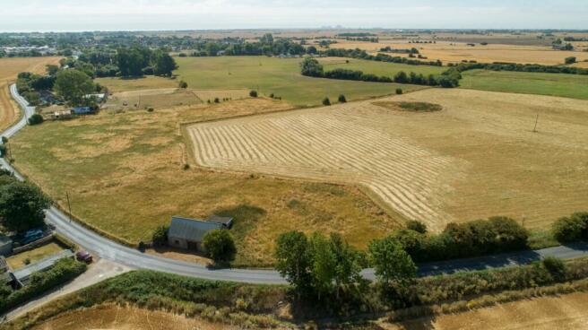
The land lies in a single contiguous block with direct vehicular access from the Ashford Road. It is understood that the land has been in permanent pasture for many years, and has been used for hay or grazing use in recent times. The land is classified as Grade 2 under the former DEFRA agricultural land classification system, and field boundaries are fenced principally with older post and wire stock-proof fencing.
The Buildings
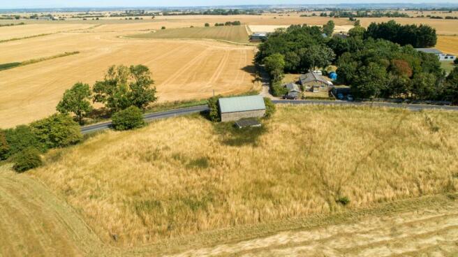
At the northern boundary of the land is a substantially built traditional agricultural barn, of brick and ragstone elevations under a green box-corrugated roof. The northern elevation of the building comprises three brick arches, later infilled with two windows and a central timber sliding door. This barn measures approximately 775 sq ft (71 sq m). At the southern end of the land is a small block-built field shelter measuring approximately 220 sq ft (20 sq m).
General
Method of sale: The property is offered for sale as a whole by private treaty. A deadline may be set for best offers and interested parties are therefore encouraged to register their interest with the selling agent at an early opportunity.
Access: The main access to the land is from the northern side directly off the Ashford Road. The Wallingham Sewer Footpath (Ref HM121) runs along the southern boundary.
Services: The land is believed to have a mains water connection, but no other services are connected. Interested parties should rely on their own enquiries as to the location, suitability and availability of service connections.
Wayleaves, Easements and Rights of Way: The property is being sold subject to and with the benefit of all rights including; rights of way, whether public or private, light, support, drainage, water and electricity supplies and other rights and obligations, easements and quasi-easements and restrictive covenants and all existing and proposed wayleaves for masts, pylons, stays, cables, drains, water and gas and other pipes whether referred to in these particulars or not.
There are no public rights of way shown on the Kent County Council Definitive Map as crossing the farm.
Basic Payment: No basic payment entitlements are included in the sale.
Designations: The land is not situated within an Area of Outstanding Natural Beauty or a SSSI. Sporting, timber and mineral rights: All mineral, timber and sporting rights are included in the freehold sale, in so far as they are owned.
Local Authority: Folkestone and Hythe District Council, Civic Centre, Castle Hill Avenue,
Folkestone CT20 2QY.
VAT: Any guide price quoted or discussed is exclusive of VAT. In the event that a sale of the property, or any part of it, or any right attached to it, becomes a chargeable supply for the purposes of VAT, such tax will be payable in addition.
Health and safety: Given the potential hazards of a working farm, we ask you to be as vigilant as possible when making your inspection for your own personal safety. Please contact Strutt & Parker on the details below to arrange a viewing.
Solicitors: Wilsons Solicitors LLP, Alexandra House, St Johns Street, Salisbury, SP1 2SB,
Overage: A new overage clause will be imposed at date of sale. The Buyer will be required to enter into an overage agreement with the Seller for a period of 25 years from the date of the purchase. If the Buyer, or any subsequent owner, obtains and implements a planning permission for residential or commercial development, including any permitted development (or sells the property with the benefit of that planning permission) the Buyer will be required to pay the Seller 25% of any uplift in value of the property. Information on this can be obtained from the selling agent
Situation
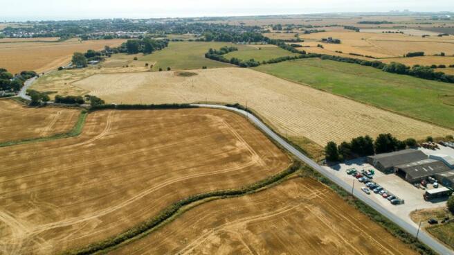
The land is situated on Ashford Road, in a rural position on the outskirts of New Romney, the town known as ‘The Capital of Romney Marsh.’ This small market town has a bustling high street of independent shops, cafés and public houses, as well as larger facilities including supermarket, schools, library and doctors surgery. The A259 provides good access south west to Rye and north east to Hythe, whilst The M20 and Ashford International Station lies approximately 16 miles to the north.
Brochures
Web DetailsParticularsAshford Road, New Romney, Kent

NEAREST STATIONS
Distances are straight line measurements from the centre of the postcode- Ham Street Station6.1 miles
About the agent
Strutt & Parker, National Estates & Farm Agency
43 Cadogan Street, London, SW3 2PR
One of the UK’s leading agents in selling, buying and letting town and country houses and cottages, London houses and flats, new homes, farms and estates and residential development land around the country with expert local knowledge backed up by national expertise to ensure a quality service.
Notes
Disclaimer - Property reference NEF220031. The information displayed about this property comprises a property advertisement. Rightmove.co.uk makes no warranty as to the accuracy or completeness of the advertisement or any linked or associated information, and Rightmove has no control over the content. This property advertisement does not constitute property particulars. The information is provided and maintained by Strutt & Parker, National Estates & Farm Agency. Please contact the selling agent or developer directly to obtain any information which may be available under the terms of The Energy Performance of Buildings (Certificates and Inspections) (England and Wales) Regulations 2007 or the Home Report if in relation to a residential property in Scotland.
Map data ©OpenStreetMap contributors.