Hady Hill, Chesterfield, Derbyshire, S41

- SIZE AVAILABLE
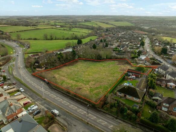
60,984 sq ft
5,666 sq m
- SECTOR
Land for sale
Description
Chesterfield is a thriving market town on the eastern edge of the Peak District National Park. Approximately 10 miles south of Sheffield and 24 miles north of Derby, the town's population was recorded as 103,600 in the 2021 census. Hady is a sought-after location lying roughly three-quarters of a mile to the east of the town centre. The subject site is situated on Hady Hill (A632), within walking distance of Chesterfield Royal Hospital at Calow.
There are excellent public transport links, with a bus stop to the site frontage, and local amenities including a Coop store at Calow, Hady Hill Primary School and St Peter & St Paul non-selective independent day school and with secondary schools a bus ride away in Hasland (1.5 miles) or Newbold (2.5 miles). Green spaces are close by, with beautiful walks including Spital Park & Tapton Golf Course.
The property is offered for sale by informal tender. In order to be considered, offers must be made on the offer form available as a linked document from the Council's website.
Please see the brochure for full details.
Brochures
Hady Hill, Chesterfield, Derbyshire, S41

NEAREST STATIONS
Distances are straight line measurements from the centre of the postcode- Chesterfield Station0.8 miles
- Dronfield Station5.4 miles
About Chesterfield Borough Council, Chesterfield
Town Hall Rose Hill, Chesterfield, S40 1LP
Notes
Disclaimer - Property reference Hadyhillland. The information displayed about this property comprises a property advertisement. Rightmove.co.uk makes no warranty as to the accuracy or completeness of the advertisement or any linked or associated information, and Rightmove has no control over the content. This property advertisement does not constitute property particulars. The information is provided and maintained by Chesterfield Borough Council, Chesterfield. Please contact the selling agent or developer directly to obtain any information which may be available under the terms of The Energy Performance of Buildings (Certificates and Inspections) (England and Wales) Regulations 2007 or the Home Report if in relation to a residential property in Scotland.
Map data ©OpenStreetMap contributors.