Plot 1, Land on the South West side of Hornes Place Oast, Kenardington Road, Appledore, Ashford, Kent
- PROPERTY TYPE
Plot
- BEDROOMS
4
- SIZE
Ask agent
Description
Set within a former farm setting, on the outskirts of the pretty, and sought after village of Appledore which is a parish within the Ashford District of Kent. Within a few minutes' drive of the village centre, which is on the northern edge of the Romney Marsh, and 12 miles (19 km) south-west of Ashford town with good transport links, including Ashford International. The B2080 is a local road which connects Appledore with the popular, and sought after tree lined Town of Tenterden, (where there is a wide array of independent shops, restaurants, banks, associated amenities and architectural rarities), and Brenzett, where it meets the A259 South Coast Trunk Road. The Royal Military Road follows the Military canal southwest from Appledore to Rye. The Marshlink Line railway line runs between Ashford International and Hastings via Appledore railway station, which is around 1.5 miles (2.4 km) from the village centre. The line reduces from dual to single track beyond the station towards Rye and Hastings. The area benefits from access to many attractions including local vineyards, country walks, and historical venues.
Directions
From our office proceed down the High Street, bearing right into Stone Street, taking the 1st right onto The Hill. Continue onto Bakers Cross, into Golford Road, continuing straight onto Tenterden Road, and onto Cranbrook Road. Turn left onto the A28, continue through Tenterden until turning right onto Oaks Road/B2067. Continue to follow B2067, turning right onto Beacon Oak Road/B2080. Continue to follow B2080, and at the junction turn left onto School Road, continue onto Kenardington Road. The entrance to Hornes Place Oast is on your right hand side, proceed down the drive and the plot is located to the rear, through a wooden five bar gate.
NB: The area of the rear garden can potentially be negotiated to be enlarged.
Planning Details.
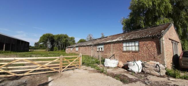
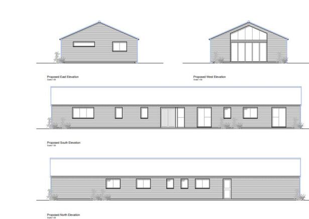
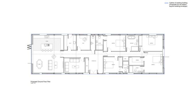
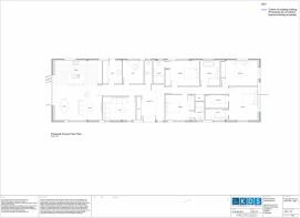
There is an extant approval for its conversion through Class Q. This is one of 2 barns which has approval for conversion into 2 separate dwellings.
The current application, reference NOT/2023/2285:-
Proposed Barn Conversion 25m South of Hornes Place Barn, Kenardington Road, Appledore
Prior approval for the change of use of 1no. building and land from agricultural to Class C3 (1no. dwellinghouse) with associated operational development.
Date Valid 19/12/2023
Application Status Decision Made
Decision Prior Approval Is Given
Agents Note: Interest is invited from cash buyers, or applicants who have secured new build finance. In line with money laundering regulations (5th directive) all purchasers will be required to allow us to verify their identity and their financial situation in order to proceed.
Council Tax Band: TBC
Tenure: Freehold
Brochures
BrochurePlot 1, Land on the South West side of Hornes Place Oast, Kenardington Road, Appledore, Ashford, Kent

NEAREST STATIONS
Distances are straight line measurements from the centre of the postcode- Appledore Station1.4 miles
- Ham Street Station3.3 miles
About the agent
LeGrys Independent Estate Agents, Cranbrook
11 High Street, Cranbrook, TN17 3EB
Notes
Disclaimer - Property reference RS1923. The information displayed about this property comprises a property advertisement. Rightmove.co.uk makes no warranty as to the accuracy or completeness of the advertisement or any linked or associated information, and Rightmove has no control over the content. This property advertisement does not constitute property particulars. The information is provided and maintained by LeGrys Independent Estate Agents, Cranbrook. Please contact the selling agent or developer directly to obtain any information which may be available under the terms of The Energy Performance of Buildings (Certificates and Inspections) (England and Wales) Regulations 2007 or the Home Report if in relation to a residential property in Scotland.
Map data ©OpenStreetMap contributors.