Crown Drive, Skirlaugh, Hull
- PROPERTY TYPE
Land
- SIZE
Ask agent
Key features
- Amenity Grass Land
- c. 0.780 acres( 0.316 ha) - Guide £23,985
- c. 0.677 acres ( 0.274 ha) - Guide £20,800
- Edge of Village Location
- Possible Alternative Uses (stp)
Description
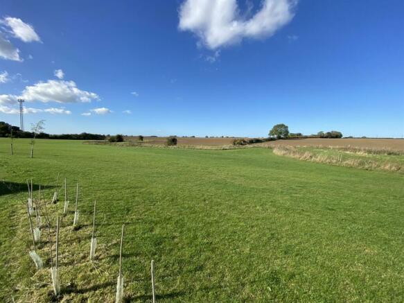
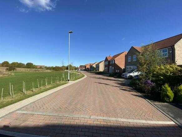
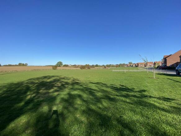
Introduction - Two pieces of land lying adjacent to the recently completed Peter Ward Homes Crown Park development in the village of Skirlaugh, the land is offered unconditionally as to planning and is considered to be suitable for continued amenity/hay cropping, conservation or possibly, the equestrian minded purchaser. Subject to the usual consents and planning approvals, the land may have potential for other alternative use(s), benefitting from a long frontage to Crown Drive and offers a rare opportunity to acquire land on the fringe of this popular Holderness village.
Location & What3words - Situated towards the north western fringe of the Holderness village of, the land parcel fringes the Crown Park development and is bounded to the north by Lambwath Stream.
The Holderness Village of Skirlaugh straddles the A165 Hull to Bridlington Road and is situated approximately 10 miles from the popular market Town of Beverley and approximately 5 miles north of the boundary to the City of Kingston Upon Hull.
What3Words: unwanted.bolsters.blurred
Description - The two parcels of land extend to approximately 0.780 and 0.677 acres (0.316 and 0.274 hectares) and are sown to grass established as part of the neighbouring development. The land gently slopes towards Lambwath Stream. A new hedge and ornamental tree planting has been carried out in part fringing Barn Street and Crown Drive. To date, the grass has been maintained/cut for hay/maintained by the Crown Park developer. Under the 1:250 000 Series Agricultural Land Classification for Yorkshire & The Humber Region, the land is classified as being Grade 2 (Very Good),
General Remarks & Stipulations -
Services - No mains services are known to be connected to the land. Mains services are believed to be available for any connection, in Crown Drive.
Wayleaves, Easements & Rights Of Way - The land is sold subject to and with the benefit of all wayleaves, easements or quasi easements and rights of way, light, support, drainage, services supplies whether mentioned in these particulars or not and without any obligations to define the same respectively. There are two foul drainage easement crossing the land in favour of Yorkshire Water Services, an existing main crossing the site from east to west and a shorter main connecting to this from the Crown Park development. There is also a surface water drain in favour of Crown Park development discharging into Lambwath Stream.
The Crown Park developers will reserve rights to continue to maintain the newly established hedges and tree plantings as an obligation of the original planning consent, for a period of 5 years from completion of the housing scheme.
Planning - Current planning policy is governed by the East Riding Local Plan and Strategy Document which was adopted April 2016 and the Policies Map adopted July 2016. Under the prevailing Local Plan, the site lies outside the development limit of the village and is not shown to be classified within any particular designation, nor is it identified under the current Local Plan Review. As a consequence, it lies within ‘open countryside’. Further enquires should be directed to the East Riding of Yorkshire Council's Planning department or you should seek your own independent advice from a Chartered Town Planner.
The Environment Agency Flood Map for Planning, indicates the majority of the land lies within Flood Zone 3, an area with a high probability of flooding.
Grants & Subsidies - The vendor has no knowledge if the land has been registered with the Rural Payments Agency and whether there has been any subsidy or grant applications over the land.
Tenure & Possession - The property is available Freehold with Vacant Possession on completion.
Method Of Sale - The land is offered by Private Treaty based upon a price guide of £23,985 for the 0.780 acre parcel and £20,800 for the 0.677 acre parcel. The vendor reserves the right to conclude the sale by any other means at their discretion, interested parties are requested to register their interest with the sole agents so they can be kept informed of the marketing progress.
Plans, Measurements & Stipulations - Any plans forming part of these particulars are included for identification purposes and do not form part of the contract for sale. Areas or measurements where stated are given as a guide only and should be checked by you or your own agent(s). Leonards and their clients give notice that they have no authority to make or give any representation or warranties in relation to the property. These particulars do not form part of any offer or contract and must not be relied upon as statement or representations of fact.
Local Authorities & Statutory Undertakers - Local & Planning Authority - East Riding of Yorkshire Council ,County Hall, Beverley HU17 9BA Tel:
Yorkshire Water - Yorkshire Water Customer Services, Western House, PO Box 52,Bradford,BD3 7YD Tel: 0345 1 24 24 24
Northern Powergrid - 98 Aketon Road, Castleford WF10 5DS Tel:
Development Uplift (Overage) - A "Development Uplift" (overage) is to be imposed on the basis that should and if the land use be changed away from agriculture, horticulture, equine or a dog exercise use either through any planning consent or permitted development rights (under the General Development Consent Order) then a "Development Uplift’"(overage) would be payable to the vendor or their successors in title. This would be based upon 30% of the increase in the Market Value of the property immediately before the planning consent/permitted development, was granted (excluding any hope value) and the Market Value of the property immediately after planning/permitted development consent is granted but taking into account the terms of any such consent. The overage/development uplift is imposed for a period of 30 years.
Contact & Viewing - During daylight hours, Please take care when viewing the property being as vigilant as possible when making an inspection for your own personal safety. For further information, please contact: Mark J Broadhurst ,
Brochures
Crown Drive, Skirlaugh, HullBrochureCrown Drive, Skirlaugh, Hull

NEAREST STATIONS
Distances are straight line measurements from the centre of the postcode- Beverley Station6.1 miles
Notes
Disclaimer - Property reference 32022172. The information displayed about this property comprises a property advertisement. Rightmove.co.uk makes no warranty as to the accuracy or completeness of the advertisement or any linked or associated information, and Rightmove has no control over the content. This property advertisement does not constitute property particulars. The information is provided and maintained by Leonards, Hull. Please contact the selling agent or developer directly to obtain any information which may be available under the terms of The Energy Performance of Buildings (Certificates and Inspections) (England and Wales) Regulations 2007 or the Home Report if in relation to a residential property in Scotland.
Map data ©OpenStreetMap contributors.