Greenway Lane, GU31

- PROPERTY TYPE
Farm Land
- SIZE
1,995,484 sq ft
185,387 sq m
Key features
- SEE AND PRINT PDF SALES PARTICULARS AVAILABLE BELOW
- SEE DRONE VIDEO FOOTAGE ON THE VIRTUAL TOUR TAB
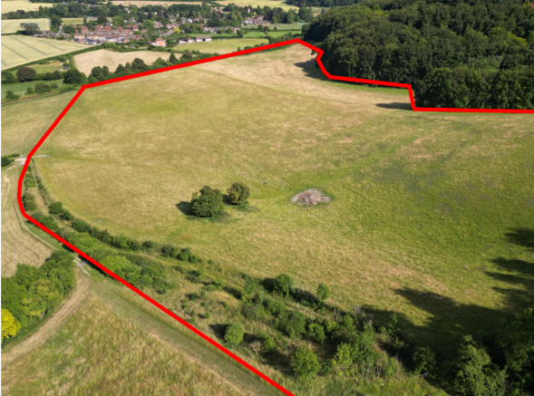
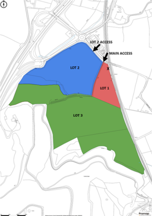
- LOT 3 - APPROX. 45.81 ACRES IN TOTAL. TOTAL OF 74.88 ACRES AVAILABLE IN 3 LOTS
- CURRENTLY GRAZED
- SHARED ACCESS
- WATER AVAILABLE
- PASTURE 38.09 ACRES. 0.55 ACRES BROADLEAVED WOODLAND
- CLOSE TO BURITON VILLAGE AND WITHIN SOUTH DOWNS NATIONAL PARK
- SUITABLE FOR AGRICULTURAL, CONSERVATION, BIODIVERSITY, EQUESTRIAN & OTHER USES
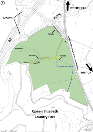
- ADJOINS QUEEN ELIZABETH COUNTRY PARK AND A3 DUAL CARRIAGEWAY
Description
VIDEO DRONE FOOTAGE: See our website further details, photographs and drone video footage is available showing the whole Property.
LOCATION: See Location Plan. The Property is located off Greenway Lane to the west of the village of Buriton and to the east of the A3 dual carriageway. Buriton is a historic village in the heart of the South Downs National Park and immediately adjoins the Queen Elizabeth Country Park. Main vehicular entrance to the Property. What3Words: cosmic.captions.segmented
DIRECTIONS: See Location Plan 1. From the A3 dual carriageway, leave via the slipways signed 'Buriton/Petersfield' and at the junction with the B2070 (to Petersfield). At the roundabout take the exit south-east signed 'Buriton' along Greenway Lane. The two vehicular access points are on the right hand side after 200 m.
DESCRIPTION: See Lotting Plan. The Property extends in all to approx. 74.88 acres (30.30 ha) consisting of approximately 71.12 acres (28.72 ha) of permanent pasture land along with approximately 3.21 acres (1.30 ha) of broadleaved woodland. The pasture land is divided into 5 parcels by internal fences with the whole being bounded by fences and established broadleaved hedgerows.
According to the Agricultural Land Classification the southern part of the land (most of Lots 3 and 4) is Grade 4 the remainder is Grade 3. The Geological Survey Map indicates the Property straddles a seam between freely draining lime-rich loamy soils to the north and shallow lime-rich soils over chalk or limestone to the south. The land is sloping along the southern edge with a north-easterly aspect.
The highest point is within Lot 3 at approximately 134 m (440 ft) above sea level with far reaching views to the north and east. The lowest point located in Lot 3 is approximately 97 m (318 ft) above sea level.
The Property has road frontage onto Greenway Lane and also the B2070. There are residential properties on the opposite side of Greenway Lane. The railway from Portsmouth to Woking with a station at Petersfield adjoins the eastern boundary of the Property.
LAND REGISTRY TITLE: The Property consists of the entirety of Land Registry Title SH21485. Please see Additional Documents for Copies of Register and Plan.
CURRENT OCCUPATION: The Vendors have Vacant Possession of the Property. The current 2024 hay crop in Lot 2 is to be harvested by a third party.
ACCESS: The main vehicular access off Greenway Lane is identified by the arrow on the Lotting Plan. This track is shared and provides access to Lots 1 and 3. Lot 2 has its own vehicular access off Greenway Lane as identified on the Lotting Plan.
LOT 1 IMPLEMENTED PLANNING PERMISSION FOR AGRICULTURAL BUILDING (2,690FT²):
6th October 2008: APP/M1710/A/08/2067316 - Two Agricultural Buildings for Use as Animal Shelters: Appeal Decision following the refusal of planning permission for application ref: 49954/001/FUL. One of the consented buildings was to be on the property being marketed at the position marked X within Lot 1 on the Lotting Plan and Site Plan. Planning permission granted, however only one of the two buildings was subsequently constructed on other land belonging to the Vendor. Ref - APP/M1710/A/08/2067316
27th June 2018: SDNP/18/02469/LDE - Certificate of Lawful Development: As only one of the buildings was actually constructed following the above permission, the purpose of this application was to confirm that development had technically commenced and been 'implemented'. The result therefore means that the second building can now be lawfully constructed within Lot 1. Ref - SDNP/18/02469/LDE
16th August 2018: SDNP/18/02459/CND - Removal of condition 10 of Appeal Decision APP/M1710/A/08/2067316 to allow land to be sold: Condition 10 of the Appeal Decision in 2008 required that the two consented agricultural buildings be demolished within 3 months in the event that the holding is subdivided or split. This application sort to remove that condition and was approved subject to conditions. Ref - SDNP/18/02459/CND . Therefore the buildings can remain, following any sale of the land.
SPECIFICATION OF AGRICULTURAL BUILDING
SIZE - 25 x 9.5m, eaves, height 3.3m, roof pitch 27 degrees
CLADDING - cedar cladding to 1.5m height with spaced, vertical timber slats to eaves - Timber to be left natural.
ROOF - Onduline, or similar, dark brown in colour
FLOORING - concrete throughout (both of these areas flood so the preferred flooring of crushed chalk is not viable in either of them).
Appeal Decision Notice, Specification and Approved Plans provided in Additional Documents on Giles Wheeler-Bennett website.
SERVICES: Mains water is connected to a number of troughs on the property.
PUBLIC FOOTPATH: A Public Footpath crosses over Lot 1 and Lot 3 as identified by the yellow dashed line on the Site Plan.
PRIVATE RIGHTS OF WAY LOT 3: A right of way was reserved for benefit of the Forestry Commission who at that point owned the woodland to the south and west of the Property (Land Registry Title No: SH20636) by conveyances dated 1st April 1958 and confirmed in one dated 1st November 1982. This right was specifically to pass over the Property (Lot 3) as shown by the blue dashed line on the Site Plan with or without vehicles from a point along the southern boundary making right damage caused but also the right to make up a metalled road of not more than 12 ft width along the route specified in the conveyance. The Forestry Commission also has the right to stack timber on the southern part of the land. These rights may never have been exercised and have not been exercised during the Vendor's ownership since 2006.
Copy of 1982 Conveyance provided in Additional Documents.
PLANNING: The Property is within the South Downs National Park and their Local Plan shows it to be in an area of 'Countryside' outside of settlement boundaries. South Downs Parkwide Local Plan policies apply. A small area of woodland located within the northern/southern boundary of Lot 3 is designated in the Local Plan as a Local Wildlife Site. An area of the land inside the northern boundary (Lots 1 and 2) against Greenway Lane and the B2070 is in the Mineral Safeguarding Zone.
An area of the land inside the northern boundary (part of Lots 1 and 2) against Greenway Lane and the B2070 is in the buffer zone of a safeguarded waste infrastructure site (John Huntly (Petersfield) Ltd.). See link - Mineral and Waste Safeguarding Policy and Plan . Under Policy 26 of the currently adopted Hampshire Minerals and Waste Plan (2013) current and potential waste sites are protected from development and also 'encroachment' where nearby land-uses impact their ability to operate.
SOUTH DOWNS NATIONAL PARK AUTHORITY: South Downs National Park, North Street, Midhurst, West Sussex, GU29 9DH.
EAST HAMPSHIRE DISTRICT COUNCIL: East Hampshire Council Offices, Penns Place, Petersfield, GU31 4EX.
BIODIVERSITY NET GAIN (BNG): There may be the potential for parts of the Property to be managed in a way, or with new habitats established, to be suitable for use as part of the new requirement for development to provide a 10% biodiversity net gain. Such BNG Credits can then be sold to developers. See the RICS note for your interest - BNG.
Brochures
Sales ParticularsGreenway Lane, GU31

NEAREST STATIONS
Distances are straight line measurements from the centre of the postcode- Petersfield Station2.1 miles
- Liss Station5.3 miles
About the agent
Giles Wheeler-Bennett, Southampton
West Court, Lower Basingwell Street, Bishop's Waltham, SO32 1AJ
Giles Wheeler-Bennett Chartered Surveyors & Land Agents is an established multi-disciplined land agency company practising throughout Hampshire and the surrounding counties and specializing in all aspects of rural property management.
We are an experienced team offering our clients a comprehensive, professional and friendly services and operate from an office in the historic market town of Bishop's Waltham.
Benefitting from an abundance of local knowledge and a reputable name, we
Notes
Disclaimer - Property reference BuritonLot3. The information displayed about this property comprises a property advertisement. Rightmove.co.uk makes no warranty as to the accuracy or completeness of the advertisement or any linked or associated information, and Rightmove has no control over the content. This property advertisement does not constitute property particulars. The information is provided and maintained by Giles Wheeler-Bennett, Southampton. Please contact the selling agent or developer directly to obtain any information which may be available under the terms of The Energy Performance of Buildings (Certificates and Inspections) (England and Wales) Regulations 2007 or the Home Report if in relation to a residential property in Scotland.
Map data ©OpenStreetMap contributors.