House and Buildings at Stone House Farm, Dillywood Lane, Rochester
- PROPERTY TYPE
Land
- SIZE
Ask agent
Key features
- Exciting Conversion / Development Opportunity for Sale in Two Lots
- Delightful Rural Location within 2.5 miles of the historic City of Rochester
- Excellent access to both road and rail networks
- Further Data available via Links to Medway Planning portal
Description
*Offers invited by way of Informal Tender for Lot 1 ,Lot 2 or both Lots combined by 12.00 Noon Wednesday 3rd May Please refer to bidding instructions adjacent to the Sales details on our website.*
Lot 1 is principally the existing house:
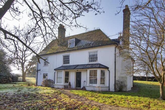
Stone House Farmhouse is a large Grade II listed building that dates from around the 18th century. Though in need of renovation, the Farmhouse’s impressive scale and rustic charm offers the potential for either an exciting executive home, or if subdivided, possibly multiple units, (subject to the necessary planning consents).
Lot 2 consists of the former agricultural buildings:
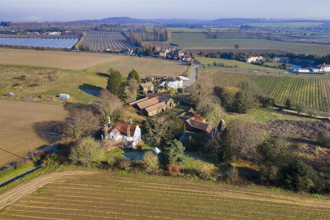
The agricultural buildings date from the 19th century and are taken to be curtilage listed. This part of the site comprises of a triple Oast with store, a cart shed/barn (South Barn), cattle shed (North Barn) and covered yard. The planning consent is to convert the 3 agricultural buildings into 5 dwellings.
Brought to the market for the first time in more than three hundred years, Stone House Farm is a rare development opportunity. The site is located to the north of Rochester, in the parish of Frindsbury, in an attractive greenbelt location. Bounded by Dillywood Lane to the north, Stone Horse Lane to the east, and farmland to south and west, the site benefits from a distinctive rural charm. Despite this, Stone House Farm is only 2.5 miles from the historic city of Rochester, with its national rail services, (37 minute train service to London Bridge), local schools, shops and other amenities. Moreover, the site is only 0.5 miles from the Wainscott bypass, which offers excellent onward connections, via the A2/M2, M20 and M25 to London, Bluewater and the coast. The Rochester area also offers plenty of history and culture with several impressive landmarks, including Rochester Cathedral, Upnor and Rochester Castles, and Chatham dockyard.
The site has been divided into 2 lots:
Lot 1 is principally the existing house
Stone House Farmhouse is a large Grade II listed building that dates from around the 18th century. Though in need of renovation, the Farmhouse’s impressive scale and rustic charm offers the potential for either an exciting executive home, or if subdivided, possibly multiple units, (subject to the necessary planning consents).
Lot 2 consists of the former agricultural buildings
The agricultural buildings date from the 19th century and are taken to be curtilage listed. This part of the site comprises of a triple Oast with store, a cart shed/barn (South Barn), cattle shed (North Barn) and covered yard. The planning consent is to convert the 3 agricultural buildings into 5 dwellings.
Brochures
Stonehouse-Farm-Draft-Details.pdfEnergy Performance Certificates
EE RatingHouse and Buildings at Stone House Farm, Dillywood Lane, Rochester

NEAREST STATIONS
Distances are straight line measurements from the centre of the postcode- Higham Station1.3 miles
- Strood Station1.3 miles
- Rochester Station1.9 miles
Notes
Disclaimer - Property reference 32189302. The information displayed about this property comprises a property advertisement. Rightmove.co.uk makes no warranty as to the accuracy or completeness of the advertisement or any linked or associated information, and Rightmove has no control over the content. This property advertisement does not constitute property particulars. The information is provided and maintained by RPC Land and New Homes, Kent. Please contact the selling agent or developer directly to obtain any information which may be available under the terms of The Energy Performance of Buildings (Certificates and Inspections) (England and Wales) Regulations 2007 or the Home Report if in relation to a residential property in Scotland.
Map data ©OpenStreetMap contributors.