Peter James Lane, Fairlight
- PROPERTY TYPE
Land
- BEDROOMS
5
- BATHROOMS
4
- SIZE
2,587 sq ft
240 sq m
Key features
- Large mixed farm
- Modern Farmhouse and annexe accommodation
- Sea views for the farm yard and house
- 792.48 acres of arable land
- 73.21 acres of grassland
- 78.78 acres of woodland
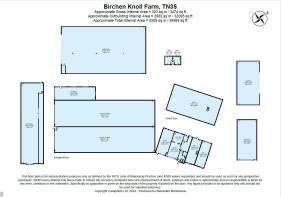
- Approximately 40,300 sq. ft of farm buildings
- Commercial let fishing lake
Description
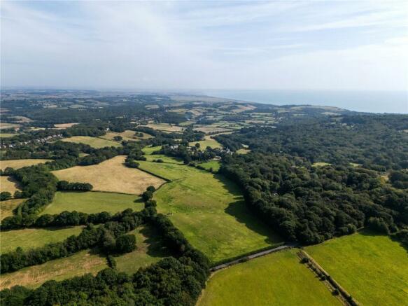
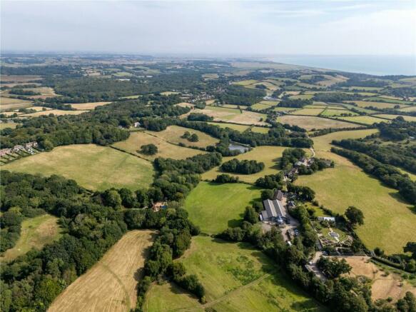
A well-equipped expansive arable and grass farm with a farmhouse and annexe accommodation, as well as a range of farm buildings and fishing lakes located within the High Weald Natural Landscape with far reaching views to the coast.
In total approximately 953.97 acres (386.05 ha)
Birchen Knoll Farm and adjoining land is a commercial mixed farm that has been farmed as a whole and extends to approximately 953.97 acres. The farm consists of suitable farmhouse accommodation with an adjoining annexe and 2 mobile homes located in the main farmyard. The land is mainly arable with 792.48 acres of Grade 2 & 3 land. In addition, there are small areas of permanent pasture 73.21 acres and 78.78 acres of woodland. This provides a good sized holding that will enable any purchaser looking to purchase the whole with a sustainable sized farming unit with the potential to modernise the farming and diversify into alternative uses making use of this popular area in East Sussex.
The property will be offered as a whole or in the lots described more specifically below. The main farming unit of Birchen Knoll Farm has been the centre of operations for the holding with the off-lying farms all easily accessed from the central holding. All off-lying farms are within a 2.8 mile radius or less of Birchen Knoll Farm.
Lot 1 – Birchen Knoll Farm
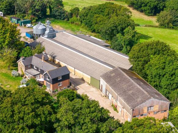
Birchen Knoll Farm is an equipped former mixed farm extending to 184.55 acres. The property consists of a 3 bed farmhouse with 2 bed annexe, 2 mobile homes and approximately 35,569 sq. ft of farm buildings. The farm is located in an elevated position to the north of Fairlight and adjoins the small village of Batchelors Bump which adjoins the larger town of Hastings. There are far reaching sea views over Rye Bay to Winchelsea Beach and Camber Sands.
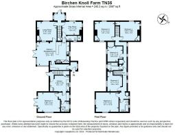
Birchen Knoll Farmhouse and Annexe
Birchen Knoll Farmhouse and Annexe was formerly a traditional brick farm worker’s cottage. It has been extended to form 2,587 sq. ft of accommodation over 2 floors with a large south facing garden. The annexe adjoins the main farmhouse and provides useful secondary accommodation.
The house has recently undergone some modernisation and provides a practical living space suitable for a working farm. Internally the accommodation consists of an open plan kitchen and dining room with exposed beams and fitted timber kitchen units and breakfast bar, back kitchen/washroom, sitting room, office or further reception room and a downstairs shower room and WC. Upstairs there are 3 double bedrooms and a bathroom.
The Annexe accommodation consists of: kitchen with fitted units, back kitchen/utility room, sitting room and downstairs shower room. Upstairs there is a large double bedroom, 1 further double bedroom and bathroom.
Farm Buildings
The farm buildings are located in the farmyard which is accessed off the main farm drive and to the north of Birchen Knoll Farmhouse & Annexe.
The buildings in the yard include the following.
Cattle Yard: Steel Portal frame barn and associated lean-to. There is a concrete floor and concrete block walls with a corrugated roof. The building has been used for cattle housing.
Workshop: A concrete portal framed barn with an electric roller shutter door with brick and corrugated clad elevations.
Hay Barn: A part open fronted steel portal framed barn with concrete panel walls, concrete floor and corrugated fibre cement roof.
Old Piggery: A former piggery building with predominantly brick elevations, corrugated roof, concrete floor and sliding doors.
Former Dairy: A concrete portal framed barn that was a former dairy and as such is split into 5 separate rooms on the ground floor that were the former tank rooms and milking parlour areas. In addition there is a central staircase that leads to the second floor.
Farm Office: A red brick built building that was the farm office to the main farm, consisting of 2 rooms and benefitting from a water connection.
Grain store & Grain dryer: A concrete portal framed former grain store and associated lead-to. The grain store is split centrally and both areas benefit from a concrete floor and roller shutter doors with grain walling internally. The grain dryer is a 90 tonne Perry through grain dryer, that has not been used for several years. The elevation height of the grain store means that tipping modern trailers would be difficult. The lean-to connected to the north elevation of the grain store is fully insulated with a concrete floor and roller shutter door.
Land
The Land at Birchen Knoll Farm surrounds the farmyard and is accessed relatively easily from the farmyard. The land extends to 187.34 acres in total of which 102.73 acres are temporary grass leys, 59.70 acres permanent pasture and 17.52 acres woodland. In addition, there is an attractive lake located in the centre of the holding. All of the Land is predominantly Grade 4 land under the MAFF Provisional Agricultural Land Classification.
Much of the topography of the temporary grassland is gently rolling and has formally been used for arable production. This land has now been included in a CS Mid-Tier agreement meaning the land is now managed as Legume and Herb Rich Swards. The permanent pasture is steeper where it leads into the valley that runs centrally through the farm. The farm has been used for the grazing of livestock and the making of forage in recent years.
The fields are mainly enclosed by mature hedgerows, boundary trees and woodland shaws. The soil survey of England and Wales records the soils as being mainly Soilscape 8: Slightly acid loamy and clayey soils with impeded drainage and Soilscape 6: Freely draining slightly acid loamy soils.
Services
The farm benefits from a 3-phase electricity connection to the farm buildings and 3 mains water supplies feeding the house, yard and field parcels. There is no mains drainage but there are 2 septic tanks servicing the Birchen Knoll Farmhouse, annexe and farm.
Access
The farm is accessed via a central farm track that leads directly from Peter James Lane, a public highway. The Land to the north benefits from direct access via a farm track on to Friars Hill which leads to the A249 and a further direct access onto Martineau Lane.
Tenure & Possession
The property is available freehold and registered under Title No: SX78322.
The property is subject to a number of leases. Full details of the above-mentioned leases are available on request from the selling agent.
Lot 2 – Land at Church Farm, Guestling
The Land at Church Farm extends to approximately 361.45 acres and is a large block of predominately arable land. All of the land is predominantly Grade 3 land under the MAFF Provisional Agricultural Land Classification. There is approximately 289.78 acres of arable land, 56.61 acres of woodland, consisting predominately of the ancient woodland known as Kitchen Wood, and finally 13.51 acres of permanent grassland.
The land has predominantly been used for conventional arable farming and benefits from large easily worked field parcels. More lately the land has been entered into a Countryside Mid-Tier agreement benefitting from the option legume fallow. The majority of the land is within 1 large, ring-fenced block with 1 separate field parcel located to the south of Church Lane, adjoining the main block.
The fields are mainly enclosed by mature hedgerows, boundary trees and woodland shaws and benefit from a good network of access points around the farm. The topography of the land is typical to this area of the High Weald with a gentle rolling gradient and much of the land being south facing. The soil survey of England and Wales records the soils as being mainly Soilscape 6: freely draining acidic loamy soils.
Services
The land benefits from a mains water connection, connected to 2 water tanks.
Access
Access is available directly from the A259 in two locations and a secondary access leading from Church Lane via a private right of access. All rights of way are shown blue on the attached sales plan.
Tenure & Possession
The Land is for sale freehold with the benefit of vacant possession and is registered under Title Nos: ESX51780, ESX28765 and ESX261124. Please note that the property included in title number ESX261124 is subject to a restrictive covenant that limits its use to agricultural purposes only.
Lot 3 - Land at Cadborough, Rye
The Land at Cadborough extends to approximately 315.26 acres and is a large block of arable land located on the coastal flats to the west of Rye Harbour. All of the land is of a Grade 2 MAFF Provisional Agricultural Land Classification.
The land has been used for conventional arable farming and maize production. The field parcels are divided by wet drainage dykes, however there are several well-constructed culverts to cross into adjoining field parcels that provide easy access around the farm. The land is intersected by the Hastings to Rye railway line, and there is a gated farm crossing providing access to the north of the railway with clear visibility down the line. The majority of the land is located to the south of the railway line.
The soil survey for England and Wales records the soils as being mainly Soilscape 21: Loamy and clayey soils of coastal flats with naturally high ground water. The internal drainage board rates are payable on this land.
Services
There are no known mains services that are connected to this land.
Access
The Land can be accessed via a private right of access leading directly from the A259 at Rye Harbour as well as Station Road leading to Winchelsea Station. Both access points rely on a right of way over third party owned land. The land benefits from road frontage onto the main A259 New Winchelsea Road. We understand that a previous owner was granted planning consent for a new access directly on the public highway in 2006, this consent was never implemented.
Tenure & Possession
The land is to be sold freehold with the benefit of vacant possession and is registered under Title No: ESX16207. The land has been farmed under a contract farming agreement by the current owners. For a copy of this agreement please contact the selling agent.
Holdover will be required until 30 September 2025 on this farm to end the current CFA and harvest the growing crops.
Lot 4 – Land at Downoak Farm, Westfield
The Land at Downoak Farm consists of a ringfenced single block of arable land with small woodland shaws. In total the land consists of 89.35 acres of which there is 84.70 acres of arable land and 4.65 acres woodland, ponds and track.
All of the land has been used for conventional arable farming growing predominantly combinable crops. The fields are mainly enclosed by mature hedgerows and boundary trees and benefit from a good network of access points around the farm. The topography of the land is typical to this area of the High Weald with a gentle rolling gradient. The soil survey of England and Wales records the soils as being mainly Soilscape 18: slowly permeable seasonally wet slightly acidic but base rich loamy and clayey soils.
Access
The land is accessed via a private right of access leading directly from the main A28. The right of access is permitted at all times and for all purposes and is via a concrete road that leads to the arable land. This private road also provides access to the neighbouring sewage works.
Tenure & Possession
The land is to be sold freehold with the benefit of vacant possession and is registered under Title No: ESX317560. The land has been farmed under a contract farming agreement by the current owners, for a copy of this agreement please contact the selling agent.
Holdover will be required until 30 September 2025 on this farm to end the current CFA and harvest the growing crops.
Lot 5 - Buildings at Downoak Farm, Westfield
The buildings at Downoak Farm consist of 2 farm buildings that are located in a former farmyard, most of which has now been redeveloped for residential or commercial uses. The site measures 0.57 acre and the buildings provide 4,800 sq. ft of floor space.
The machinery store is a concrete portal frame building with corrugated roof and concrete block walls. There is a concrete floor and sliding tin clad door to the north facing gable. The former workshop consists of a concrete portal framed building with concrete block elevations under a corrugated roof. There is a small concrete yard between both buildings.
The buildings now provide potential for alternative uses subject to the necessary consents.
Services
The buildings benefit from a mains water and electricity connection.
Access
The land is accessed via a private right of access leading directly from the main A28. The right of access is permitted at all times and for all purposes.
Tenure & Possession
Please contact the agent for more details on the tenure of this property.
GENERAL REMARKS
Environmental Stewardship
There is a Countryside Stewardship Mid-Tier agreement over 4 Lots with a combined annual income of £75,691, expiring on 31/12/2027. In addition, there is also a Countryside Stewardship Higher Tier agreement in place at Kitchen Wood on Lot 2 with an annual income of £2,155, this agreement expires on 31/12/2025.
Full details of the agreements are available on request from the selling agent. The purchaser will be required to take on the existing agreements with the agreements being transferred from the Vendor to the Purchaser on completion. The agreements will be transferred in whole or part depending on the lotting. All payments for 2024 will be retained by the Vendor and depending on the timing of the sale the 2025 payment will be split proportionately.
For avoidance of doubt there will be no Basic Payment Scheme de-linked reference data included with this sale.
Designations
All properties are included in the High Weald Natural Landscape and the majority of the woodland included in the various lots is classified as Ancient Woodland.
Sporting Rights
The sporting rights are to be included within the sale insofar as they are owned. The fishing rights at Lot 1 are currently let to a third party and the shooting rights at Lot 2 are also let on a shooting licence. For more information on these agreements please contact the selling agents.
Timber and Mineral Rights
Rights to timber and minerals are to be included in the sale insofar as they are owned.
Overage
The sale will be subject to an Overage of 15% for 40 years on the area hatched blue on the sales plan as a result of any uplift in the value of the land as a consequence of planning permission for a change of use outside of that required for agricultural purposes.
The Overage will be triggered on either implementation of the planning permission or disposal of the property with the benefit of the consent.
Boundaries
The purchaser must satisfy themselves on the location of all boundaries from their own inspection and from the Land Registry plans available from the vendor’s agent.
The purchaser of Lot 2 will be responsible for fencing the boundary marked with an inward facing T on completion, fencing specification to be agreed.
Guide Price as a whole - £10,340,000 or in lots:
Lot 1 - £2,900,000
Lot 2 - £3,150,000
Lot 3 - £3,300,000
Lot 4 - £790,000
Lot 5 - £200,000
Brochures
ParticularsEnergy Performance Certificates
EPC Rating GraphPeter James Lane, Fairlight

NEAREST STATIONS
Distances are straight line measurements from the centre of the postcode- Three Oaks Station1.8 miles
- Ore Station2.6 miles
- Doleham Station2.8 miles
About Batcheller Monkhouse Professional, Tunbridge Wells
1 London Road, Tunbridge Wells, TN1 1DH

Notes
Disclaimer - Property reference TWP240003. The information displayed about this property comprises a property advertisement. Rightmove.co.uk makes no warranty as to the accuracy or completeness of the advertisement or any linked or associated information, and Rightmove has no control over the content. This property advertisement does not constitute property particulars. The information is provided and maintained by Batcheller Monkhouse Professional, Tunbridge Wells. Please contact the selling agent or developer directly to obtain any information which may be available under the terms of The Energy Performance of Buildings (Certificates and Inspections) (England and Wales) Regulations 2007 or the Home Report if in relation to a residential property in Scotland.
Map data ©OpenStreetMap contributors.