Alpaca Meadow, Hensting Lane, SO21

- PROPERTY TYPE
Land
- SIZE
88,862 sq ft
8,256 sq m
Key features
- SEE AND PRINT PDF SALES PARTICULARS AVAILABLE BELOW
- SEE DRONE VIDEO FOOTAGE ON THE VIRTUAL TOUR TAB
- APPROXIMATELY 2.04 ACRES IN ALL
- COMPACT PADDOCK
- FIELD SHELTERS
- WC (SEPTIC TANK)
- FENCED
- WATER CONNECTED
- CONVENIENT ACCESS AND OFF ROAD PARKING
- ATTRACTIVE RURAL LOCATION
Description
VIDEO DRONE FOOTAGE: See our website for further details, photographs and drone video footage is available showing the whole Property.
LOCATION AND DIRECTIONS: See Location Plans 1 and 2. Vehicular access: What3Words: Postcode: SO21 1LE.
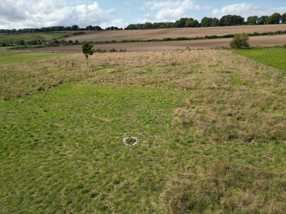
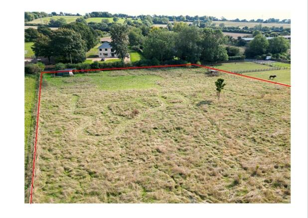
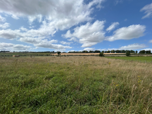
DESCRIPTION: The Property extends to 2.04 acres (0.82 ha) in all as outlined red on the Site Plan. It comprises pasture land with field shelters and a toilet block connected to a septic tank. It has previously been grazed by alpacas but more recently has been in amenity use. The paddock is fenced separately away from the access allowing more convenient access and off-road parking. There is road frontage with Hensting Lane along the south-eastern boundary. An area of pens has been created with post and rail fencing at the southern corner of the Property.
The pasture land is well drained and level with grazing possible all year round. According to National Soil Classification data the land is Grade 3 with shallow lime-rich soils over chalk and limestone.
LAND REGISTRY: The Property comprises the entirety of Land Registry Title No. HP726595. The Land Registry Title Register and Plan are available on the Selling Agent's website.
BOUNDARIES AND FENCING: The Land is bounded by post and rail fencing. There is established native hedging between the Property and Hensting Lane.
FIELD SHELTER: There are three structures on the Property as listed below. These are included in the Property and Price Guide.
Building 1 (Approx. 5.15m by 5.73m) - Timber framed field shelter with corrugated metal cladding and felt roof. Currently used for storage.
Building 2 (Approx. 5.81m by 2.31m) - Open-sided low timber field shelter
Building 3 (Approx. 1.39m by 1.39m) - Timber toilet cubicle
PLANNING AND PLANNING DESIGATIONS: The Property is outside settlement boundaries and therefore Parkwide Policies Apply. The only recent planning application on record was for the siting of a temporary mobile home for occupation by an agricultural worker in 2014. This application was refused and a subsequent appeal dismissed. See Planning Authority contact details below.
DESIGNATIONS: The Property is situated within the South Downs National Park and a National Character area. It is also within a Nitrate Vulnerable Zone. No other significant environmental or planning designations have been identified.
SERVICES: The Property is connected to mains water. Electricity is likely to be available nearby. The toilet on site is serviced by a septic tank approximately at the position marked X on the Site Plan.
PUBLIC RIGHTS OF WAY: No public rights of way affect the Property.
LOCAL AUTHORITY: Winchester City Council (WCC), City Offices, Colebrook Street, Winchester SO23 9LJ
SOUTH DOWNS NATIONAL PARK (SDNP): South Downs Centre, North Street, Midhurst, West Sussex GU29 9DH
Brochures
Sales ParticularsAlpaca Meadow, Hensting Lane, SO21

NEAREST STATIONS
Distances are straight line measurements from the centre of the postcode- Shawford Station2.2 miles
- Eastleigh Station4.2 miles
- Winchester Station4.2 miles
About Giles Wheeler-Bennett, Southampton
West Court, Lower Basingwell Street, Bishop's Waltham, SO32 1AJNotes
Disclaimer - Property reference AlpacaMeadow. The information displayed about this property comprises a property advertisement. Rightmove.co.uk makes no warranty as to the accuracy or completeness of the advertisement or any linked or associated information, and Rightmove has no control over the content. This property advertisement does not constitute property particulars. The information is provided and maintained by Giles Wheeler-Bennett, Southampton. Please contact the selling agent or developer directly to obtain any information which may be available under the terms of The Energy Performance of Buildings (Certificates and Inspections) (England and Wales) Regulations 2007 or the Home Report if in relation to a residential property in Scotland.
Map data ©OpenStreetMap contributors.